Categories
- 26May 26, 2026
Long Haulers Hike NEW TIME NEW LOCATION
https://hikes.brucetrail.org/event/long-haulers-hike-new-time-new-location-2/Sorry, the registration cut-off time for this hike has been reached.Not a member? Click here to join today!Hosting Club: Niagara
Location (Google Maps): Short Hills Wiley Road, Thorold
Pace: Fast 5+ km/hr
Terrain: Moderate: some hills and some poor footing
: 10k+Description
Back to our regular Spot for the Tuesday Long Hike. Note the new location. We will hike the trails around Short Hills Dress for the weather and bring sunscreen bug spray, poles snack and drink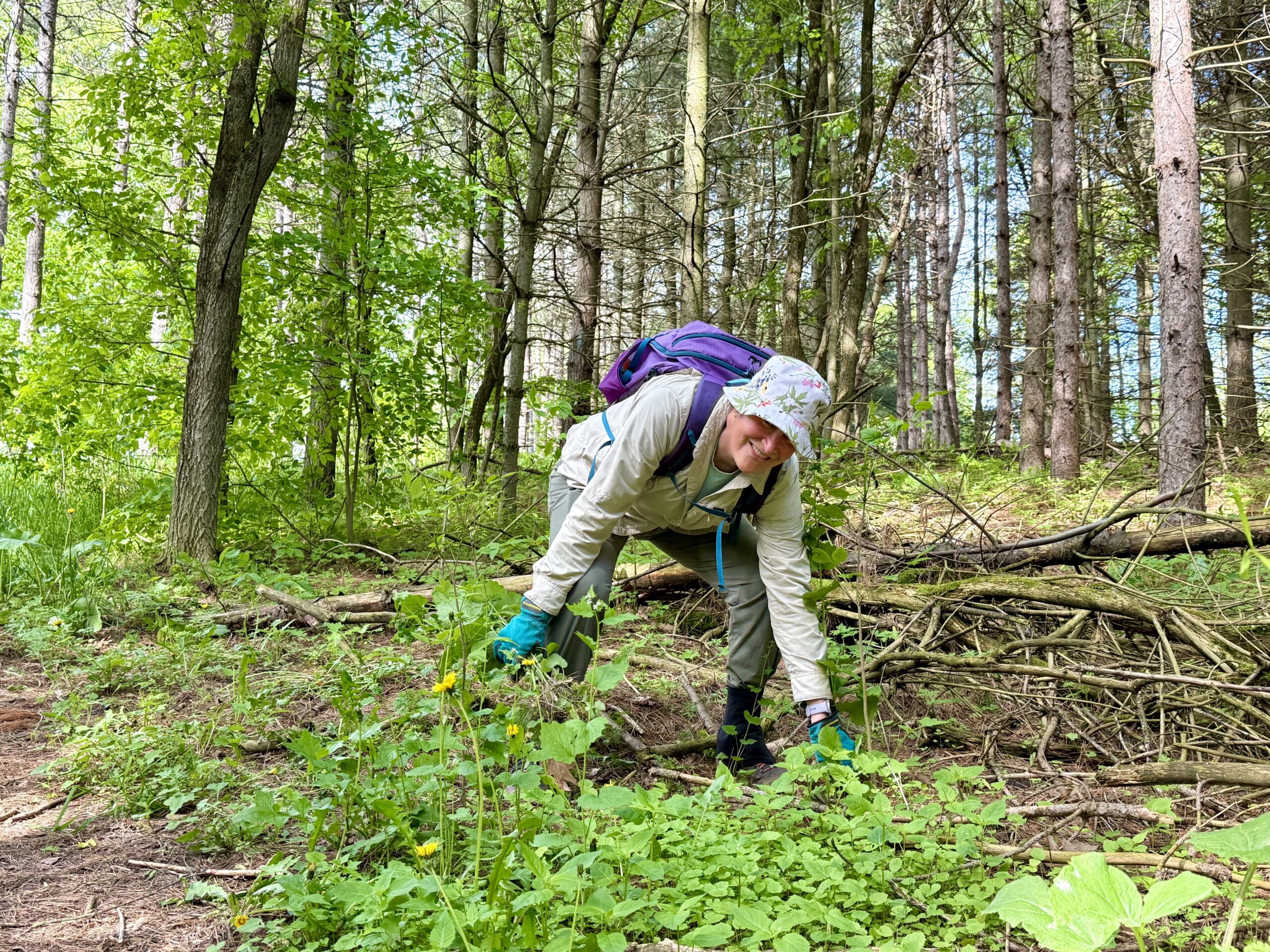
Habitat Restoration Project - Controlling the Spread of Garlic Mustard
https://hikes.brucetrail.org/event/habitat-restoration-project-controlling-the-spread-of-garlic-mustard-2/Sorry, the registration cut-off time for this hike has been reached.Not a member? Click here to join today!Hosting Club: Caledon Hills
Category: Habitat Restoration Project
Location (Google Maps): Meet at the parking lot on the east side of 3rd Line EHS, 43.992646, -80.047917.Directions: From ON-10 head east on Hockley Rd./Dufferin County Rd. 7 for 6.5 km. Turn left onto 3rd Line EHS and drive for 1.0 km. Parking is on the right.
Hike Leader(s): Sandy Green Click here to contact Hike Leader(s)
Pace: Leisurely – 3 km/hour or less
Terrain: Moderate – some hills and/or some poor footing
Distance: 2 kilometresDescription
Volunteers are needed to help control the spread of garlic mustard at the Hockley Valley Provincial Nature Reserve. Join Ron and Sandy to pull the invasive species by hand or if you prefer, bring a small trowel or dandelion weeder. Wear long sleeves and long pants. Pack gloves, sunscreen, insect repellent, a beverage, and a snack. The work is satisfying, and the camaraderie is always fun. All are welcome to help enhance biodiversity.9:15 Short Hike, Rotary Park, St. Catharines
https://hikes.brucetrail.org/event/915-short-hike-rotary-park-st-catharines-21/Sorry, the registration cut-off time for this hike has been reached.Not a member? Click here to join today!Hosting Club: Niagara
Category: Hike
Location (Google Maps): Rotary Park, 376 Regional Rd 69, St CatharinesHike Leader(s): Debbie Demizio Click here to contact Hike Leader(s)
Pace: Medium
Terrain: Moderate
Distance: 6 kmDescription
Hike the trails around Rotary Park, St. Catharines. Please bring water, hiking poles and appropriate footwear.Urban Walk: Valley View Park
https://hikes.brucetrail.org/event/urban-walk-valley-view-park-thornhill-171/Sorry, the registration cut-off time for this hike has been reached.Not a member? Click here to join today!Hosting Club: Toronto
Location (Google Maps): Parking lot is off Sycamore Drive, East of Bayview , across Starbucks plaza
Bus 91 from Finch East station stops at Sycamore station.Hike Leader(s): MOHAMMAD AGHAMIRI Click here to contact Hike Leader(s)
Pace: Moderate (3-4 km/hr)
Terrain: Hilly, Level 2 (Intermediate – some hills and uneven surfaces, rocks and roots underfoot)
Distance (km): 6-7 kmDescription
We will explore Valleyview and Maple View parks, and walk along German Mill Creak, in return we stop in Huntington park and have snack under beautiful shed.Although this is considered an “Urban Walk”, you can expect some hills up and down and uneven surfaces with tree roots. Please bring hiking poles, Ice cleats water and snacks.
Kelso Summit (reservation required)
https://hikes.brucetrail.org/event/kelso-summit-reservation-required-2/Sorry, the registration cut-off time for this hike has been reached.Not a member? Click here to join today!Hosting Club: Iroquoia
Category: General Hike
Location (Google Maps): Kelso Summit parking lot at 9:15 am (reservation required)Hike Leader(s): Karen Bergmann Click here to contact Hike Leader(s)
Pace: Medium – 3 to 4 km/hr
Terrain: Moderate – Some hills and/or some poor footing
Distance: 8 kmsDescription
Meet at 9:15 in the Summit parking lot. We will explore the trails for a large loop and enjoy spring wildflowers along the way. Reserve your time at conservationhalton.ca for KELSO SUMMIT.Forks of the Credit Loop from Willoughby Road
https://hikes.brucetrail.org/event/forks-of-the-credit-loop-from-willoughby-road/Sorry, the registration cut-off time for this hike has been reached.Not a member? Click here to join today!Hosting Club: Dufferin Hi-Land
Category: Tuesday Hike
Location (Google Maps):Caledon Hills Secion Map 15, Met at intersection of Willoughby Rd and Escarpment SR (km 15.8)
Hike Leader(s): Inge Eckerich, Tony Evangelista, Les Babbage, Julie Daley Click here to contact Hike Leader(s)
Pace: Leisurely
Terrain: Moderate
Distance: 9 Km. Short hike 5 kmDescription
We will hike along the Main Trail to the end of Puckering Lane and continue into Forks of the Credit Provincial Park and loopback. Short hike will turn back at Puckering LaneHilton Falls Conservation Area Trails
https://hikes.brucetrail.org/event/hilton-falls-conservation-area-trails-5/Sorry, the registration cut-off time for this hike has been reached.Not a member? Click here to join today!Hosting Club: Iroquoia
Category: General Hike
Location (Google Maps): Hilton Falls Conservation Area parking lot, Campbellville Rd/Side Rd 5 East of Guelph Line Rd. Reservation required along with Conservation pass or fee for parking.Hike Leader(s): Karen Capindale-Smith Click here to contact Hike Leader(s)
Pace: Brisk – 4 to 5 km/hr
Terrain: Easy – Mostly flat and usually good footing
Distance: 13kmDescription
We will hike the Beaver Dam loop and part of the Hilton Falls and Red Oak Trails at a brisk speed. There will an opportunity to visit the falls and stop for other sights along the way but please know that we will be moving at a clip. Please bring water, a snack and appropriate layers for the weather. Note: the finish time has been extended by 45 min to ensure the completion of the full 13km while still having an opportunity to enjoy the scenery/take breaks.Baked goods can be expected 🙂
Tuesday Trekkers- Dufferin (km 0-19.4) 1of 3
https://hikes.brucetrail.org/event/dufferin-km-0-19-4-1of-3/Sorry, the registration cut-off time for this hike has been reached.Not a member? Click here to join today!Hosting Club: Beaver Valley
Location (Google Maps): Meet at Mono Cliffs Community Centre. 200m south of Mono Centre (County rd 8) Park in gravel lot
We will shuttle to roadside parking on 1st line (km19.4) Map19 Ed 31Hike Leader(s): Kristina Rettie Click here to contact the hike leader.
Pace: Brisk, Medium
Terrain: Moderate, Some rocky footing, Some steep sections, Strenuous
Length of Hike: 20 kmDescription
This Dufferin E2E will take place over 3 Tuesdays. Come out for all of them and earn you Dufferin E2E badge (you can apply for this independenly) or just come to the ones that interest you. We will start at km 0 and make our way north to km 55.5 covering the entire Dufferin section.This will be a car shuttle hike so please come with your car passenger ready. We will all take turns being the shuttle driver.
This time of year we can expect all types of trail conditions. Please be prepared with for the condition of the day.
Bring water lunch and a snack
Please no dogs
Walk In Nature Series (WINS) Tuesday Summer Evenings - West Rocks
https://hikes.brucetrail.org/event/walk-in-nature-series-wins-west-rocks/Sorry, the registration cut-off time for this hike has been reached.Not a member? Click here to join today!Hosting Club: Sydenham
Category: General Hike
Location (Google Maps): Click the Google Maps link to take you there. Meet and park at the dead end of Concession 3, north of Grey Rd 5 near Creamery Hill/Waverley Heights in the former Derby Township. In the Bruce Trail Reference, Edition 31, meet just past km 96.1 on Map 32.Hike Leader(s): Stewart Brown Click here to contact Hike Leader(s)
Pace: Medium: 3 to 4 km/h
Terrain: Easy: Mostly flat and good footing.
Distance: 5 kmDescription
Tuesday evening WINS hikes begin at 6:30 p.m. as a way to enjoy the daylight and nice weather of summer evenings. Enjoy a loop in the West Rocks area on the forested trails with scenic lookouts over Owen Sound.