Categories
- 20May 20, 2026
8:30am Queenston Training Hike
https://hikes.brucetrail.org/event/830am-queenston-training-hike/Sorry, the registration cut-off time for this hike has been reached.Not a member? Click here to join today!Hike open to BTC Members only.
Hosting Club: Niagara
Category: Loop
Location (Google Maps): Locust Grove Picnic Area. Parking is free.Hike Leader(s): Suzanne Gourluck Click here to contact Hike Leader(s)
Pace: Brisk 4-5 km/hr
Terrain: Strenuous: hilly, with steep climbs, poor footing
Distance: 8 kmDescription
Do you need to do some training for an upcoming holiday or some Bruce Trail End to Ends? Then come and join us on this challenging loop in Queenston Heights.We will start at Locust Grove and go up the main flight of stairs to the monument. Then descend another flight of stairs down into Queenston where we will take the hill down to the dock before returning to the start to make it a loop.
We will repeat this together a few times!Be warned, the long flights of stairs and hills will make this a challenging hike so please consider this before signing up.
Please dress appropriately and bring water and poles.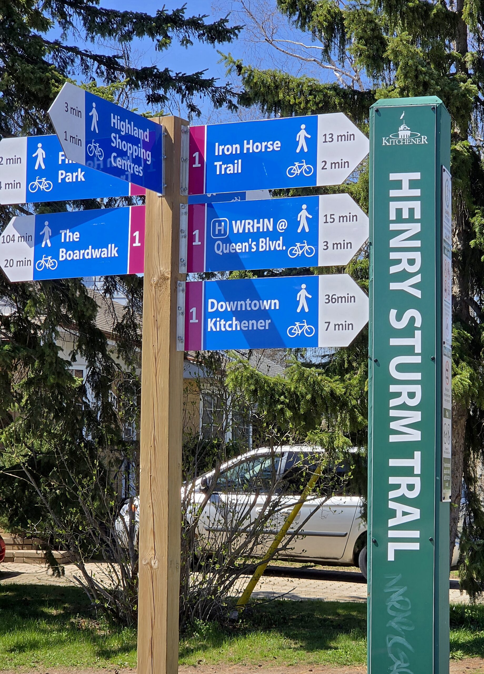
Waterloo Region Wednesday Wayfairers
https://hikes.brucetrail.org/event/waterloo-region-wednesday-wayfairers/Sorry, the registration cut-off time for this hike has been reached.Not a member? Click here to join today!Hosting Club: Caledon Hills
Category: General
Location (Google Maps): Meet at The Beer Store, 875 Highland Rd. W., (Highland Rd. and Fischer-Hallman Rd.)Hike Leader(s): Dan Patterson Click here to contact Hike Leader(s)
Pace: Medium – 3 to 4 km/hour
Terrain: Easy – mostly flat and usually good footing
Distance: 10 kmDescription
Meet at 8:45 a.m. and walk on the Henry Strum Trail connecting with the Hearth Green Trail to Lakeshore Park, then take the Conestoga Parkway overpass to Strasburg & Ottawa Streets for coffee. We will return on the same route back to the cars. Study boots, sufficient water, snacks and a good attitude are required. Poles are optional. This is a very flat trail.Birding Hike with David Turner
https://hikes.brucetrail.org/event/birding-hike-with-david-turner/Sorry, the registration cut-off time for this hike has been reached.Not a member? Click here to join today!Hosting Club: Blue Mountains
Category: Organized Hike
Location (Google Maps): We will meet at Tim’s and carpool to parking on 9/10 Sideroad Nottawasaga south of Nottawasaga Bluffs CA.Hike Leader(s): Jim Lewis Click here to contact Hike Leader(s)
Pace: Leisurely – 3 km/hr. or less
Terrain: Moderate – Some hills and/or some poor footing
Distance: 5kmDescription
Please join us for this birding hike, led by birding expert David Turner. David started birding as a youth in his home town in England, where he was born. He has been actively studying the birds in the Beaver Valley for over 15 years and has spotted over 230 species of the known 240 species. David started the Beaver Valley Birding Club, to bring together birding enthusiasts. It has over 770 members and is still growing. It will be a treat and very educational to spend some time with David as he shares his expertise.We will meet at Tim’s on 1st Street in Collingwood and carpool to Conc 10 Nottawasaga and follow the trail east past a beautiful meadow where Bobolinks nest. We will look for singing males defending their territories. There is a mix of hardwoods, cedars, and a sparkling stream that should provide more birds and spring wildflowers. We will loop back to our cars having completed about a 5 km hike. Bring your binoculars!
Spaces will be limited to 15 hikers, so please register in advance.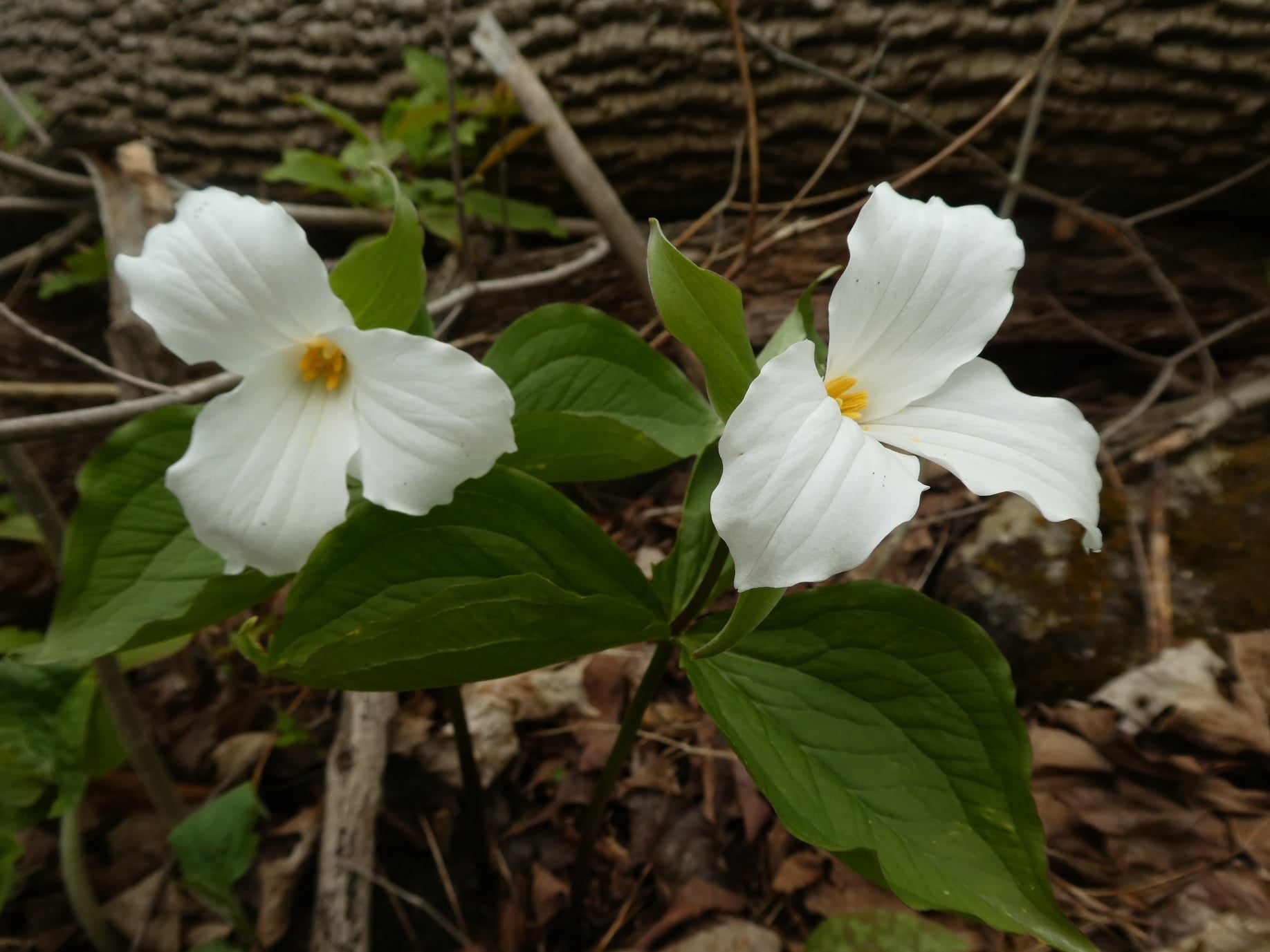
Halton Agreement Forest
https://hikes.brucetrail.org/event/halton-agreement-forest/Sorry, the registration cut-off time for this hike has been reached.Not a member? Click here to join today!Hosting Club: Iroquoia
Category: General Hike
Location (Google Maps): Meet at the corner of 10 Side Road and 4th Line at 9:15 am.Hike Leader(s): Karen Bergmann Click here to contact Hike Leader(s)
Pace: Medium – 3 to 4 km/hr
Terrain: Moderate – Some hills and/or some poor footing
Distance: 8 kmsDescription
On the lookout for Trillium and other wildflowers. We will hike the bike trails around a big loop. Bring bug spray/bug net and plenty of water.WEDNESDAY WALKERS - Loree Forest
https://hikes.brucetrail.org/event/wednesday-walkers-loree-forest-4/Sorry, the registration cut-off time for this hike has been reached.Not a member? Click here to join today!Hosting Club: Beaver Valley
Location (Google Maps): Paid parking on the shoulder of the 21st Side Road. Map 24, Edition 31 (Arrangements can be made in advance to shuttle to the trailhead.)
Hike Leader(s): Margaret Yaraskavitch Click here to contact the hike leader.
Pace: Medium
Terrain: Easy
Length of Hike: 6.5 kmsDescription
We will take the access road into Loree Forest where we will then walk a loop. Most of the Trail is flat. There will be views of Nottawasaga Bay and a walk through a mature deciduous forest. Then we take the access road back to our parking area. A popular well-enjoyed route. Please bring water.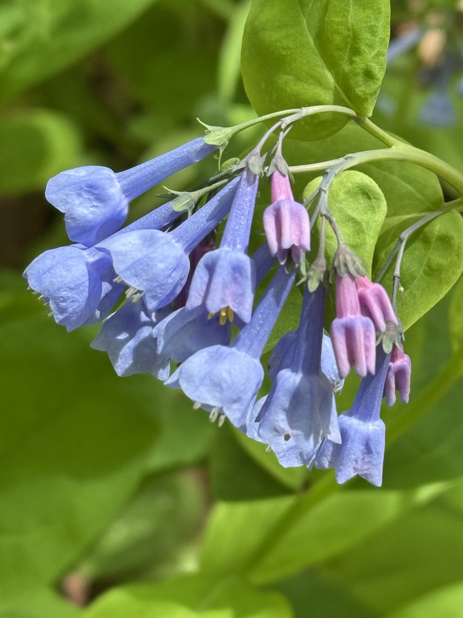
Annual Bluebell Hike
https://hikes.brucetrail.org/event/annual-bluebell-hike-2/Sorry, the registration cut-off time for this hike has been reached.Not a member? Click here to join today!Hosting Club: Iroquoia
Category: Good Companions
Location (Google Maps): Oakville, Sixteen Mile Creek ValleyHike Leader(s): Anne Armstrong Click here to contact Hike Leader(s)
Pace: Leisurely – 3km/hr or less
Terrain: Moderate – Some hills and/or some poor footing
Distance: Approx. 9 km. – 10 km.Description
Please join in this hike to savour the many wildflowers which grow in the Sixteen Mile Creek Valley, especially the Virginia Bluebells. Depending on the season’s progress they should be at their best. Please meet in the parking lot at the end of Old Upper Middle Rd., located south of the current Upper Middle Rd. and west of Oxford St. We will hike north into the valley and complete a loop, bringing us back to the start. Bring water, a snack, sunscreen and insect repellent. Poles may be useful for the hills. I will send out a message the day before with my contact information in the event that you need to cancel the morning of the hike.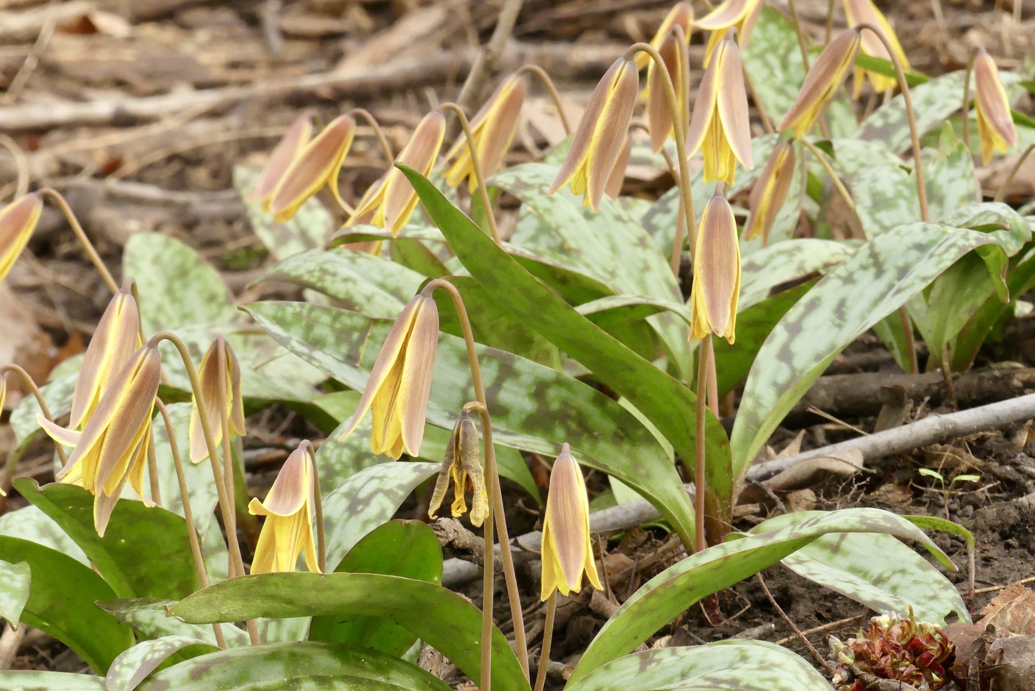
Car Hike: Tiptoe through the Wildflowers
https://hikes.brucetrail.org/event/car-hike-tiptoe-through-the-wildflowers/Sorry, the registration cut-off time for this hike has been reached.Not a member? Click here to join today!Hosting Club: Toronto
Category: Car Hike
Location (Google Maps): We will meet at the roadside parking on Third Line (Map 12)Hike Leader(s): Janet Patterson; Angelika Sommer Click here to contact Hike Leader(s)
Pace: Leisurely (2-3 km/hr)
Terrain: Level 1 (Easy – mostly on flat, well maintained trails with hard-packed surface), Variable
Distance (km): Approx 5 – 6 kDescription
Join us for a leisurely walk through a variety of forested areas and wetlands, on the main trail and the Charles Hildebrandt Side Trail. Together with our plant experts Angelika, Gen and Rose Mary, we will search for native wildflower species that thrive before the trees fully “leaf out”, and discuss their role in the forest ecosystem.This will be an ideal opportunity to document your sightings for the club’s Biodiversity Naturalist badge.
What to bring:
- water (1 litre minimum), lunch, snacks
- Sun screen, hat
- Insect repellent
- Smart phone, if you plan to use iNaturalist
This hike is brought to you by the TBTC Biodiversity Team. We endeavour to promote the critical role we can all play in protecting and conserving the Niagara Escarpment.
Limit of 10 participants
RAINBOW HIKE: Japanese Interval Walking - Chedokee Trail
https://hikes.brucetrail.org/event/rainbow-hike-japanese-interval-walking-chedokee-trail/Sorry, the registration cut-off time for this hike has been reached.Not a member? Click here to join today!Hosting Club: Iroquoia
Category: Rainbow Hike
Location (Google Maps): Hillcrest Loop, bottom of Dundurn stairsHike Leader(s): Doug O’Neill Click here to contact Hike Leader(s)
Pace: Brisk – 4 to 5 km/hr, Leisurely – 3km/hr or less
Terrain: Easy – Mostly flat and usually good footingDescription
Everyone is welcome on this uber-friendly, all-inclusive 2SLGBTQAI+ Rainbow Hike.Japanese Interval Walking was a hit last summer and fall so we’ll try it again this season!
Tonight’s hike, along the Chedokee Trail and Robert MacLaren Sidetrail, features an opportunity to try Japanese interval walking (Nihon-shiki)—for at least two 30-minute segments. You’re welcome to hike at your own pace for part of the evening. We’ll stay on flat, rock-free sections of the trail. Suitable for first-timers.
How Japanese Interval Walking works:
• Alternate 3 minutes of brisk walking (enough to raise your heart rate and make talking difficult) with 3 minutes of slower, recovery walking
• Each cycle = 6 minutes; we’ll repeat it five times for a total of 30 minutes
• If everyone agrees, we’ll try another 30-minute interval toward the end of our hike.
• No one gets left behind (and if they did, well, we’ve not heard from them since)
The surprising part: last season’s participants actually found they had to force themselves to walk slowly for the slow segment. It’s a lot of fun!Everyone gets a Bruce Trail Rainbow Badge. Again, this is NOT a high-intensity hike.
Bring water, perhaps a snack if you’ve skipped dinner, and sturdy shoes (runners will work for this hike). Or lightweight hiking boots.
Coming by transit?: the No 7 Hillcrest Loop bus will drop you off right where we’ll begin the hike.
Driving: there’s parking on various side streets off Dundurn.Meeting spot: look for the benches at foot of Dundurn Stairs, next to bus loop.
Questions? Simply click “Contact Hike Leader” on the registration form.