Categories
- 01November 1, 2025
School Bus Hike: Dufferin Highland, Murphy's Pinnacle
https://hikes.brucetrail.org/event/school-bus-hike-dufferin-highland-murphys-pinnacle/Sorry, the registration cut-off time for this hike has been reached.Not a member? Click here to join today!Trip Information
Departure Time: 08:30
Return to City Time: 18:30
Departure Point: York Mills Bus PickupOptional Items
Pick up at HWY 400 and Major Mac ($0.01)Hosting Club: Toronto
Category: Bus Hike
Location (Google Maps): Dufferin Highland, Murphy’s PinnacleHike Leader(s): Martina Furrer, Janet McColeman, Robin Crombie, Duro Vukman Click here to contact Hike Leader(s)
Pace: Brisk (4-5 km/hr), Moderate (3-4 km/hr)
Terrain: Hilly, Level 2 (Intermediate – some hills and uneven surfaces, rocks and roots underfoot), Variable
Distance: Fast group 16 to 18 km, Moderate group 13 kmDescription
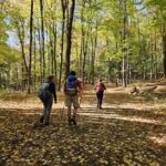
Join us for a fantastic fall hike in the Dufferin Highlands (Map 20). Enjoy awesome views from Murphy’s Pinnacle and the Mulmur Lookout.We will split into two groups. The fast group will do the Primrose Loop Side Trail and then follow the main trail north to km 29.6 (about a 16 km hike). If time permits the fast group will also do the Rock Hill Park Side Trail. The moderate group will head straight to Murphy’s Pinnacle and follow the main trail north to km 29.6 (about a 13 km hike).
Pack water, lunch, sun and rain protection.
Refreshment stop in Primrose if time allows.
Bus departs at 8:30 am from 10 York Mills Rd. We hope to be back in the city by 6 pm.
- 01November 1, 2025
Car Hike: Seaton Trail
https://hikes.brucetrail.org/event/car-hike-seaton-trail/Sorry, the registration cut-off time for this hike has been reached.Not a member? Click here to join today!Hosting Club: Toronto
Category: Car Hike
Location (Google Maps): Seaton Trail Parking Lot, PickeringHike Leader(s): Mohammad Aghamiri Click here to contact Hike Leader(s)
Pace: Moderate (3-4 km/hr)
Terrain: Hilly, Level 2 (Intermediate – some hills and uneven surfaces, rocks and roots underfoot)
Distance: 12-14 kmDescription
We will hike along Seaton trail and enjoy the lovely scenery of forest and river. - 01November 1, 2025
F&G Hills 3
https://hikes.brucetrail.org/event/fg-hills-3/Sorry, the registration cut-off time for this hike has been reached.Not a member? Click here to join today!Hosting Club: Dufferin Hi-Land
Category: General Hike
Location (Google Maps): Meet at 1st Line Bruce Trail Mulmur Hills Parking lot.Hike Leader(s): Tristan Goguen Click here to contact Hike Leader(s)
Pace: Medium
Terrain: Slippery and Steep Sections, Strenuous
Distance: 15 Km approximatelyDescription
Hike 3 of this hills series. We will meet at the 1st Line parking lot then car pool back to Centre road. From there we will hike on the main trail down to the Boyne Valley Side Trail. We will return to the main trail and enjoy all the hills and valleys the Boyne area offers. Once we return to the 1st Line parking lot we have the option to explore the Rock Hill side trail before returning to the cars. Please wear hiking shoes or boots, bring snacks/lunch and water. Dress for the weather. Note the hike leaders will have 2 dogs on this hike. This hike involves challenging climbs and is recommended for experienced hikers only. - 01November 1, 2025
Car Hike: #6/7 Iroquoia Bruce Trail End-to-End -21 KM
https://hikes.brucetrail.org/event/car-hike-6-7-iroquoia-bruce-trail-end-to-end-21-km/Sorry, the registration cut-off time for this hike has been reached.Not a member? Click here to join today!Hosting Club: Toronto
Category: Car Hike
Location (Google Maps): KM83.5. Roadside parking on Guelph LineHike Leader(s): Alina Lin
Pace: Brisk (4-5 km/hr)
Terrain: Level 2 (Intermediate – some hills and uneven surfaces, rocks and roots underfoot)
Distance: 21 kmDescription
Let’s make this hike extra fun with a Halloween theme! You’re encouraged to dress up as whoever you want to be and enjoy a festive walk in the forest. Just remember — no matter what your costume is, sturdy hiking footwear is a must!This is the 6th hike of an End-to-End series covering the entire Iroquoia Bruce Trail section. The full section stretches over 120 kilometers from Grimsby to Milton. I am using Map Edition 29 to plan the hikes, and so please note that kilometer markings may not be fully up to date, and actual hiking distances may vary slightly.
Meeting Point:
KM83.5. Roadside parking on Guelph Line, south of No. 1 Sideroad. GPS: 43.388387, -79.854327. Please arrive before 8:45am to allow time for car shuttle coordination.We will car shuttle to 103.8KM Roadside Parking on Twiss Rd North of Derry Rd. GPS: 43.447743, -79.953436. From there to hike back to KM83.5.
All drivers are expected to participate in the car shuttle, either before or after the hike. All hikers are expected to chip in for parking fees, if applicable.
Important Notes:
- Wear sturdy hiking footwear and dress appropriately for the weather
- Bring snacks, and at least 1.5L of water
- No dropouts available.
- No pets.
- 01November 1, 2025
9:00 From Mountainview CA to Beamer Memorial CA and Back
https://hikes.brucetrail.org/event/900-from-mountainview-ca-and-beamer-memorial-ca-and-back/Sorry, the registration cut-off time for this hike has been reached.Not a member? Click here to join today!Hike open to BTC Members only.
Hosting Club: Niagara
Category: In and Out
Location (Google Maps): Mountainview Conservation AreaHike Leader(s): Karen Couch Click here to contact Hike Leader(s)
Pace: Brisk
Terrain: Strenuous
Distance: 20-22 kmDescription
Meet in the Mountainview Conservation Area (CA) parking lot and hike to Grimsby Point Bluff (Beamer Memorial CA). After a short break, we will retrace our path.This section of the trail has some steep, technical ascents and descents. We will be rewarded with some beautiful lookout points.
Consider your fitness level before registering. Everyone is expected to keep up with the person in front of them for the duration of the hike.
Dress for varying weather conditions. Hiking poles and boots are highly recommended. Bring fluids and a snack.
Plan to arrive at the start point by 8:45 as we will leave at 9:00 sharp.
- 01November 1, 2025
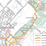
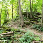
RAINBOW HIKE: Smokey Hollow Waterfall to Waterdown Woods to Kerncliff Park & Beyond
https://hikes.brucetrail.org/event/rainbow-hike-smokey-hollows-waterfalls-to-fishers-pond-and-back/Sorry, the registration cut-off time for this hike has been reached.Not a member? Click here to join today!Hosting Club: Iroquoia
Category: Rainbow Hike
Location (Google Maps): Smokey Hollow Waterfall to Waterdown Woods & BeyondHike Leader(s): Doug O’Neill Click here to contact Hike Leader(s)
Pace: Medium – 3 to 4 km/hr
Terrain: Moderate – Some hills and/or some poor footing
Distance: 14 kmDescription
Come by car or transit for this all-inclusive 2SLGBTQI+ friendly Rainbow hike from Smokey Hollow Waterfall, Waterdown to Waterdown Woods and beyond.Please arrive at the Smokey Hollow parking lot, 80 Mill St. South, by 9:15 a.m. for a 9:30 a.m. start.
This is the same starting point as our October 13th hike—but we’ll be exploring in the opposite direction. (Ideal for anyone planning to complete their E2E).
Today’s 14 km in-and-out hike follows the Bruce Trail Main Trail with detours alongKing Side Trail, Ian Reid Side Trail, and if time allows we’ll aim for one of the International Friendship Trails.
By transit to the starting point. The easiest route is to take HSR transit or GO Bus (depending where you live) to Aldershot GO station, then hop on the 18 Leavitt Loop bus and get off at “Mill St. at Mountain Brow,” a 3-minute walk to the Smokey Hollows parking lot. The bus drivers on this route are accustomed to hikers.
By car: There is unpaid parking at Smokey Hollow, which can fill up early. If lot is full: There’s street parking on Flanders Drive, about a 15-minute walk to Smokey Hollows. PLEASE allow yourself enough time to sort out your parking so you can arrive at Smokey Hollows parking lot by 9:15 a.m latest.
Post-hike refreshments: The Royal Coachman in Waterdown has long been hiker-friendly.
Bring 1 litre of water and lunch. (Since it’s November, a thermos of something hot wouldn’t go amiss. Hiking boots or sturdy footwear are recommended. Dress in layers. Always bring some kind of rain gear. Yup, it’s that time of year 🙂
Get your complimentary Bruce Trail Rainbow badge and/or sticker at the end of the hike!
Feel free to reach out to the Hike Leader if you have any questions – “Click here to contact Hike Leader” on this form.
- 01November 1, 2025

Forty Hills Sidewinder
https://hikes.brucetrail.org/event/forty-hills-sidewinder/Sorry, the registration cut-off time for this hike has been reached.Not a member? Click here to join today!Hosting Club: Peninsula
Location (Google Maps): Bruce Trail Parking Area at Forty Hills (GPS: 45.020460, -81.283790).
Hike Leader(s): Marg and Owen Glendon Click here to contact Hike Leader(s)
Pace: Medium (3.0 – 4.5 km/h): A comfortable pace for most hikers with steady progress.
Terrain: Difficult: Steep ascents/descents, rocky scrambling, and some rugged escarpment paths., Moderate: Rolling hills, mild slopes and rocky paths.
Distance: ~11 kmDescription
We invite you to join us for this fun “figure 8” hike which includes five side trails! We will hike on the sidetrails of White Bluff Provincial Nature Reserve and along the beautiful escarpment overlooking Georgian Bay and Lion’s Head Harbour. This hike twists and turns like a sidewinder through quiet meadow, mixed forest and rocky ups-and-downs!Bring your lunch or snack for a brief stop at Reed’s Dump. Duration of the hike will be ~ 3 1/2 hr. Portapottie available at the Forty Hills parking lot and basic outdoor toilet available at Reed’s Dump.
Sturdy footwear with good grip is recommended. Good balance and endurance are required.
Free coffee and muffin for hike participants arriving by 9:15 a.m.
- 01November 1, 2025
Urban Walk; Victoria Park subway station to Sunnybrook Park
https://hikes.brucetrail.org/event/urban-walk-victoria-park-subway-station-to-sunnybrook-park-2/Sorry, the registration cut-off time for this hike has been reached.Not a member? Click here to join today!Hosting Club: Toronto
Category: Urban Walk
Location (Google Maps):Start at Victoria Park subway station ticket collector. Several dropouts along the way. Final destination is Sunnybrook Health Centre on Bayview Ave
Hike Leader(s): Ray Berzins Click here to contact Hike Leader(s)
Pace: Moderate (3-4 km/hr)
Terrain: Level 1 (Easy – mostly on flat, well maintained trails with hard-packed surface)
Distance: 8.5 kmDescription
From Victoria Park subway we shall walk northeast along the Taylor Creek to the Don River, follow the West Don River to Sunnybrook Park. At Sunnybrook Health Centre on Bayview Ave is TTC #11 bus that connects with Davisville subway station and TTC #124 bus that connects with Lawrence subway.We shall have a picnic halfway so bring a sandwich and a thermos.
Check your email at 8AM on day of hike to verify hike status.
- 01November 1, 2025
Saturday Shorts: Cold Creek
https://hikes.brucetrail.org/event/saturday-shorts-cold-creek-3/Sorry, the registration cut-off time for this hike has been reached.Not a member? Click here to join today!Hosting Club: Caledon Hills
Category: General
Location (Google Maps): Meet at the main gate entrance. Park roadside near the gate. Please do not drive into the park past the main gate, as we are starting out on the loop from this point. The park address is 14125 11th Concession, King (near Nobleton). The GPS coordinates will lead you into the park past the main gate. Please aim to arrive at 10:15 am for a 10:30 am start. Thanks!
Note: Because of construction on 11th Concession, take 11th Concession going south to reach the conservation area. You cannot go north on 11th Concession from King Road.Hike Leader(s): Elizabeth Ganong Click here to contact Hike Leader(s)
Pace: Leisurely – 3 km/hour or less, Medium – 3 to 4 km/hour
Terrain: Easy – mostly flat and usually good footing, Moderate – some hills and/or some poor footing
Distance: Approximately 6 kmDescription
Looking to get out on a Saturday but not give up your whole day? Saturday Shorts, a hiking series, will get you out in a small group on a short hike. This Saturday’s hike is an enjoyable one in any season. We’ll hike the outer loop, making about a 6 km route, at Cold Creek Conservation Area. Things to consider in your hike preparations: warm gear/dressing in layers, hiking shoes/boots, poles, water, a snack. There will be a short break. No dogs please. Registrants can expect a reminder/update message one or two days before the hike. - 01November 1, 2025

Car Hike: A hike to celebrate Halloween!
https://hikes.brucetrail.org/event/car-hike-a-hike-to-celebrate-halloween/Sorry, the registration cut-off time for this hike has been reached.Not a member? Click here to join today!Hosting Club: Toronto
Category: Car Hike
Location (Google Maps): We will meet at the larger parking lot in Woodend Conservation Area, 1 Taylor Rd, Niagara-on-the-Lake, ON L0S 1J0 (coordinates: 43.150276, -79.155092).Hike Leader(s): Monica Pasquali Click here to contact Hike Leader(s)
Pace: Leisurely (2-3 km/hr)
Terrain: Level 1 (Easy – mostly on flat, well maintained trails with hard-packed surface), Level 2 (Intermediate – some hills and uneven surfaces, rocks and roots underfoot)
Distance: 8 km total, divided into two hikes of 4 km eachDescription
Calling all hikers who love Halloween and working on badge requirements!Today we will complete two of the three required hikes for the Niagara Bruce Trail Club’s Screaming Tunnel Badge. First, we’ll complete a 4 km out-and-back hike along the main Bruce Trail from Woodend Conservation Area to the “Screaming Tunnel” – please wear/bring your Halloween costume/hat for a photo op which is one of the requirements for the badge. Then we’ll all hop into our cars and drive about 11 km west to DeCew House Heritage Park, stopping for lunch along the way. After parking at DeCew House Heritage Park (address: 2370 DeCew Rd, Fonthill, ON L0S 1E6; coordinates: 43.107568, -79.249598) we’ll complete another 4 km out-and-back hike, but this time along the Bert Lowe Side Trail in order to visit another tunnel which is another requirement for the badge.
Youth who are 15 years of age and under are encouraged to join their parents/guardians on this hike so they can also fulfill the requirements for the Niagara Bruce Trail Club’s Youth Hiking Badges. The Young Trail Blazer Badge simply requires the completion of one hike on the Niagara Bruce Trail, which our young participants will earn by completing today’s hikes. The Young Nature Blazer’s Badge requires our young participants to pay attention to what they see and hear during today’s hikes and then complete a write-up describing what they observed. Please note that all family members who are planning on joining us should register for the hike, including children.
All hikers who register for today’s outing should bring water and snacks, comfortable hiking shoes, appropriate clothing for the weather, and payment for lunch if you intend to join us for lunch at a restaurant (e.g., Harvey’s).
Information about all Niagara Bruce Trail Club badges can be found here: https://niagarabrucetrail.club/badges/ Please note that you will have to complete the third hike required for the Screaming Tunnel Badge by joining a “Witch of Cave Springs Hike” organized by the Niagara Bruce Trail Club in October/November, so keep an eye on the BTC hike schedule so you don’t miss your opportunity to do this: https://hikes.brucetrail.org/