Categories
- 17November 17, 2024
Bruce Trail into Dundas Valley Conservation
https://hikes.brucetrail.org/event/bruce-trail-into-dundas-valley-conservation/Sorry, the registration cut-off time for this hike has been reached.Not a member? Click here to join today!Hosting Club: Iroquoia
Category: General Hike
Location (Google Maps): The Blue side trail starts from the road/sidewalk. There is street parking on Davidson Blvd. We’ll meet at the trail head.Hike Leader(s): Madeline Grady Click here to contact Hike Leader(s)
Pace: Medium – 3 to 4 km/hr
Terrain: Moderate – Some hills and/or some poor footing
Distance: Approx 8km,Description
This is an out and back hike with some loops from the conservation area added. There are steep areas, stairs and roots. Hiking boots and poles are recommended. Bring along water and a snack and dress for the weather.Car Hike: Speyside - Blue and White Trails – 22KM
https://hikes.brucetrail.org/event/car-hike-speyside-blue-and-white-trails-22km/Sorry, the registration cut-off time for this hike has been reached.Not a member? Click here to join today!Hosting Club: Toronto
Category: Car Hike
Location (Google Maps): We meet at the Parking area on St. Helena Road. This is a small road just off Halton Road 25. If you are coming from 401 exit for Hwy 25, it will be up the hill after you cross 10 Side Road. You have to turn left to enter the Road. Watch for traffic.Hike Leader(s): Fayyaz Mahmood Click here to contact Hike Leader(s)
Pace: Brisk (4-5 km/hr)
Terrain: Level 2 (Intermediate – some hills and uneven surfaces, rocks and roots underfoot)
Distance: 22 KMDescription
This is my favourite hike.We will walk to the trail-head at the end of St. Helena road. We will walk the main trail going South-East from 8.9KM, Map 12 Ed 31 to the point where it meets the Hilton Falls Side Trail at 1.4KM. We will walk the Hilton Falls Side Trail having lunch at Hilton Falls. Then proceed to Vanderlick ST turning right to meet the Al Shaw ST to meet the Main Trail at 10.6KM and return back to the parking lot about 2.5KM.
Bring 1.5 – 2 liters of water and your lunch. Please dress for the weather.9:00 Witch of Cave Spring Hike
https://hikes.brucetrail.org/event/900-witch-of-cave-spring-hike-2/Sorry, the registration cut-off time for this hike has been reached.Not a member? Click here to join today!Hosting Club: Niagara
Category: In and Out
Location (Google Maps):Parking lot Quarry Road Beamsville
Hike Leader(s): Angela Lytle Click here to contact Hike Leader(s)
Pace: Medium
Terrain: Moderate
Distance: 5 kmDescription
Enjoy a beautiful hike through the autumn woods and learn about local historical and mystical lore while searching for the Witch of Cave Spring.Complete this guided hike and count it towards the Screaming Tunnel Badge, more info on the badge requirements is here: https://niagarabrucetrail.club/badges/
Wearing a witch hat, while not required, is highly recommended!
Details:
This hike loops from Quarry Rd in Beamsville (limited parking, carpool if possible) along the Bruce Trail to Cave Spring Conservation area and back.
Note: The path to Cave Spring is quite rocky and has some hills. We recommend using hiking poles and wearing good hiking shoes is a must. Carry water and dress for changeable weather.
We will stop along the way at sites of interest and loop back to the car park on Quarry Rd. The loop is around 5 km. Please arrive by 8:50 to check in with the hike leader for departure at 9.

Peninsula Blue Series - Exploring Dyer’s Bay Area
https://hikes.brucetrail.org/event/peninsula-blue-series-exploring-dyers-bay-area/Sorry, the registration cut-off time for this hike has been reached.Not a member? Click here to join today!Hosting Club: Peninsula
Category: Peninsula Blue Series
Location (Google Maps): Borchardt Rd, Northern Bruce Peninsula, ON N0H 1W0Hike Leader(s): Saabir Sohrab Click here to contact Hike Leader(s)
Pace: Medium
Terrain: Moderate, Difficult
Distance: ~10kmDescription
Join us for an exciting 10 km hike through the stunning Dyer’s Bay Area.. We’ll primarily traverse the BTC Protected Area. Our hike will take us through beautiful woodlands 🌳, dramatic cliffs 🏔️, serene shorelines 🌊, and unique geological features, including the iconic Flowerpot and Michiganders Arch.The hike will cover approximately 10 km at an average speed of 3 km/h, taking about 4 to 5 hours to complete. The terrain is moderate to difficult, so be prepared for a range of challenges. The expected temperature during our hike is around 5°C, so dressing in layers is essential for comfort 🧥.
Side Trails We Will Explore:
- Devil’s Monument Side Trail: Marvel at the impressive sea stack known as the “Flowerpot,” formed approximately 5,500 years ago by glacial Lake Nippissing 🌌.
- Minhinnick Side Trail: Named after landowner who provided an interpretive plaque at Devil’s Monument 📜.
- Lillie Pothole Side Trail: Discover a future geological gem—a 4-meter diameter and 4-meter deep glacial pot hole 🔍.
- Lillie Family Side Trail: This trail is dedicated to John and Sue Lillie, long-time supporters and land donors ❤️.
- Cottrill Lake Side Trail: Named after a dedicated employee of the Ministry of Natural Resources and Forestry 🌿.
- Anne & Clayton Roberts Side Trail: Recognizing decades of outstanding trail maintenance, this path reflects the dedication of trail captains Anne and Clayton Roberts’s 🛠️.
To ensure a great experience, please wear sturdy shoes with good traction 👟 and bring snacks and lunch to keep your energy up 🍎. Don’t forget to carry plenty of water as well! 💧
Let's Get Started- Day 2of 2
https://hikes.brucetrail.org/event/lets-get-started-day-2of-2/Sorry, the registration cut-off time for this hike has been reached.Not a member? Click here to join today!Hosting Club: Niagara, Iroquoia
Category: General Hike
Location (Google Maps): Meet up at Decew Falls parking of Morning Star Mill. From there we will shuttle to the parking area (GPS coord 43.145576-79.191260) on the east side of Glendale Ave Bridge (Welland Canal) – across from the GM Plant.Hike Leader(s): Karen Capindale-Smith Click here to contact Hike Leader(s)
Pace: Medium – 3 to 4 km/hr
Terrain: Moderate – Some hills and/or some poor footing
Distance: 15.5 kmDescription
Day 2 hike will start along the Canal and meet up with the Merritt Trail. We will travel past Brock University and around Lake Moodie before finishing at Decew Falls. Please come dressed for the weather (layers). Icers may be necessary. Remember to bring water, a snack and lunch. Expect baked goods 🙂Dufferin Hi-Land Membership Appreciation Pre-Social Hike
https://hikes.brucetrail.org/event/dufferin-hi-land-membership-appreciation-pre-social-hike/Sorry, the registration cut-off time for this hike has been reached.Not a member? Click here to join today!Hike open to BTC Members only.
Hosting Club: Dufferin Hi-Land
Category: Special Events
Location (Google Maps): Mono Community Centre, 200m south of Mono Centre (County Road 8). Park in gravel lot.Hike Leader(s): Stuart Law Click here to contact Hike Leader(s)
Pace: Leisurely
Terrain: Dependent on Conditions, Slippery Sections Likely, Easy
Distance: 6 kmsDescription
The Dufferin Hi-Lands Bruce Trail Club celebrates and thanks its members, volunteers and landowners with speakers (including BTC CEO Michael McDonald and well-travelled hike enthusiast Linda Murphy) and a lunch at the Mono Community Centre at noon. Join us for a pre-Social hike taking in the South Outlier Loop and Laidlaw Side Trails by way of warm-up to the main event. Hiking boots and a smile are mandatory but poles are optional (although recommended). Please see the Dufferin Hi-Land club’s website for registration details for the lunch.
Car Hike: Dufferin Hi-Land in 10 (New Fundraising Badge: $30/BTC member; $40/non-member)
https://hikes.brucetrail.org/event/car-hike-dufferin-hi-land-in-10-new-fundraising-badge-30-btc-member-40-non-member/Sorry, the registration cut-off time for this hike has been reached.Not a member? Click here to join today!This is a Multi-Day Hike
You are signing up for the following dates:
2024-11-17, 2024-12-15, 2025-01-12, 2025-03-02, 2025-03-23, 2025-05-25, 2025-06-22, 2025-07-13, 2025-08-24, 2025-09-20Hosting Club: Toronto, Dufferin Hi-Land
Category: Car Hike
Location (Google Maps): For our first hike, we will meet at roadside parking on 2nd Line EHS (km 2.2 on Map 19 of the Bruce Trail Reference Guide, Edition 31).Hike Leader(s): Monica Pasquali Click here to contact Hike Leader(s)
Pace: Leisurely (2-3 km/hr), Moderate (3-4 km/hr)
Terrain: Level 2 (Intermediate – some hills and uneven surfaces, rocks and roots underfoot), Rocky, Variable
Distance: 10-11 km per hikeDescription
Calling all families with children who love hiking and earning badges!!!All registered hikers – including participating children – will earn the Dufferin Hi-Land Yellow Lady’s Slipper stained-glass badge!!!
You are registering for the following nine Sundays and one Saturday of this 2024-2025 hike series led by TBTC guest hike leader Monica Pasquali: November 17, December 15, January 12, March 2 (hike rescheduled from February due to snowstorm), March 23 (hike rescheduled from March 16 due to high winds and flooding risk), May 25, June 22, July 13 (hike rescheduled from April due to ice storm damage clean-up), August 24, and September 20 (hike rescheduled from July 27 due to excessive heat).
Hikers must strive to complete all ten hikes with the leader. Hikers are permitted to miss three of the ten hikes due to unforeseen circumstances; if this happens, they will make up the hike(s) on their own so they can still qualify for the badge. Please keep a log of the missed hike(s) and give it to the leader on the last day of the series.
The fee for this hike series goes towards supporting the Dufferin Hi-Land Bruce Trail Club, which in turn supports the mission of the Bruce Trail Conservancy in “preserving a ribbon of wilderness, for everyone, forever”.
This hike is intended to be leisurely/moderate (approximately 3 km/h). Please, register only if you are capable of sustaining this pace over varied/rocky terrain for a distance of 10-11 km.
We will NOT be doing car shuttles so that families (with already-full cars!) can participate. All of the hikes in this series will be out-and-back hikes.
You should wear sturdy footwear and appropriate clothing for the weather, and ensure you bring your ID cards and enough water and food for the entire hike.
Exploring Sydenham Hikes 18 and 19
https://hikes.brucetrail.org/event/exploring-sydenham-hikes-18-and-19-2/Sorry, the registration cut-off time for this hike has been reached.Not a member? Click here to join today!Hosting Club: Sydenham
Category: General Hike
Location (Google Maps):Meet in the north-east corner of the parking lot at Home Depot on Highway 26 on the east side of Owen Sound.
Hike Leader(s): Bill Snel Click here to contact Hike Leader(s)
Pace: Leisurely: 3 km/h or less
Terrain: Moderate: Some hills and/or poor footing
Distance: 4 kmDescription
Originally schedule for Sun 10 Nov but changed because of deer hunting season. We will carpool to do modified Rock Springs and KOA loop hikes. The modification is due to trail changes. These are hikes 18 and 19 in the book, Exploring Sydenham. There is one secret to locate. If you do not have a book and would like one ($30) let me know by using the “Contact hike leader” link. - 18November 18, 2024
Toronto E2E (with some km's in CH & 1 km in Iroquoia on Nov. 25)
https://hikes.brucetrail.org/event/toronto-e2e-with-some-kms-in-ch-1-km-in-iroquoia-on-nov-25/Sorry, the registration cut-off time for this hike has been reached.Not a member? Click here to join today!Hike open to BTC Members only.
This is a Multi-Day Hike
You are signing up for the following dates and times:
2024-11-18 at 07:30
2024-11-19 at 07:30
2024-11-20 at 07:30
2024-11-25 at 07:30Hosting Club: Iroquoia, Toronto, Caledon Hills
Category: End-to-End
Location (Google Maps): Roadside parking where the main trail meets Heritage Rd.Hike Leader(s): Heather Murch Click here to contact Hike Leader(s)
Pace: Brisk – 4 to 5 km/hour
Terrain: Strenuous – hilly with steep climbs and some poor footing
Distance: 21.4 kmDescription
This is the seventh section in our Cairn to Cairn hike series this fall. Heather Murch and Steven White are co-leading these hikes. Strong hikers are welcome to join for sections or individual hikes, but will need to register for each end to end section series. This series of hikes are 20-24 kms per day and due to parking or hike length, some hikes cover more than one section.We meet at 7:15 – hikers should be ready to shuttle at that time. We will take turns and everyone is expected to participate in the shuttling. Any parking costs will be shared.
There is another End to End hike series posted by Steven for those who want to hike and receive a special Stained Glass badge.
Hikers should wear layered clothing, bring rainwear, poles, hiking boots, hat, water, snacks, lunch, bug spray, sunblock and be prepared for changing weather this time of year.
Hiking itinerary with parking coordinates will be emailed to registered hikers.Toronto Stained Glass End 2 End (Nov18,19,20)
https://hikes.brucetrail.org/event/toronto-stained-glass-end-2-end-nov181920/Sorry, the registration cut-off time for this hike has been reached.Not a member? Click here to join today!This is a Multi-Day Hike
You are signing up for the following dates:
2024-11-18, 2024-11-19, 2024-11-20Hosting Club: Iroquoia, Toronto, Caledon Hills
Category: Stained Glass Badge End to End Fundraiser Hike
Location (Google Maps): Heritage Rd where main trail crossesHike Leader(s): Steven White Click here to contact Hike Leader(s)
Pace: Brisk – 4 to 5 km/hr
Terrain: Strenuous – Hilly with steep climbs and some poor footing
Distance: 21.4kmDescription
This is the seventh section in our Cairn to Cairn hike series this fall. Heather Murch and I are co-leading these hikes. Strong hikers are welcome to join for sections or individual hikes, but will need to register for each end to end section series. This series of hikes are 20-24 kms per day and due to parking or hike length, some hikes cover more than one section.
We meet at 7:30 – hikers should arrive early and be ready to shuttle at that time. We will take turns and everyone is expected to participate in the shuttling. Any parking costs will be shared.
There is another End to End hike series posted by Heather for those who want to hike and not receive this special Stained Glass badge.
Hikers should wear layered clothing, bring rainwear, poles, hiking boots, hat, water, snacks, lunch, bug spray, sunblock and be prepared for changing weather this time of year.
Hiking itinerary with parking coordinates will be emailed to registered hikers.
Iroquoia E2E Series 3 of 8
https://hikes.brucetrail.org/event/iroquoia-e2e-series-3-of-8/Sorry, the registration cut-off time for this hike has been reached.Not a member? Click here to join today!Hosting Club: Iroquoia
Location (Google Maps): Parking Lot at Artaban Road – Fee required by Hamilton Conservation Authority
Hike Leader(s): Pati Greenwood, Jeff Dowsett Click here to contact Hike Leader(s)
Pace: Medium – 3 to 4 km/hr
Terrain: Moderate – Some hills and/or some poor footing
Distance: 17.3Description
Join us for this 3rd hike of the of 8 hike series to complete the Iroquoia Section of the Bruce Trail. Register for all 8 hikes (to be entitled to the badge) or only the ones you are available for. Car shuffle and other hike details will be emailed to registered hikers a few days prior to the hike. Bring plenty of water and a snack. Wear appropriate clothing for conditions. Hiking boots are mandatory and hiking poles are suggested. Please arrive at the meeting place by 8:15 am as we will leave promptly at 8:30 am to shuffle to our starting point.
Men's Hike: Sunrise Shores Nature Reserve
https://hikes.brucetrail.org/event/mens-hike-sunrise-shores-nature-reserve/Sorry, the registration cut-off time for this hike has been reached.Not a member? Click here to join today!Hosting Club: Peninsula
Location (Google Maps): Rush Cove
Hike Leader(s): Owen Glendon Click here to contact Hike Leader(s)
Pace: Leisurely, Medium
Terrain: Difficult, Moderate
Distance: ~4 kmDescription
Explore the new Sunrise Shore Nature Reserve, located between Rush Cove and Barrow Bay. This in-out hike will follow the Main Bruce Trail along the shoreline with views of the turquoise water, escarpment cliffs and mixed forest. At the Ivan Lemke Connector Sidetrail, the group will decide if they would like a more challenging option for the return trip, by hiking to the top of the escarpment along the Ivan Lemke Sidetrail through the forest to our parked vehicles.Check the weather forecast and dress accordingly. Bring water and a snack. Sturdy footwear is required and hiking poles are suggested. Hiking poles are available , if needed.
Head south from Ferndale on Highway 6. Turn left (east) onto Barrow Bay Road to the end. Turn right (south) onto Bruce County Road 9. Turn left (east) onto Scenic Caves Road. Turn left (north) on Rush Cove Road. Park at the large roadside parking area on the west side of Rush Cove Road. Total driving time from Ferndale is about 20 minutes.
- 19November 19, 2024
Urban Walk: Valley View Park Thornhill
https://hikes.brucetrail.org/event/urban-walk-valley-view-park-thornhill-34/Sorry, the registration cut-off time for this hike has been reached.Not a member? Click here to join today!Hosting Club: Toronto
Location (Google Maps): Parking lot at the corner of Bayview Ave, and Sycamore Dr. South of Highway 7
Sycamore Dr. is 3blocks south of highway 7 and 2 blocks north of John Street, parking lot is across plaza of Dollarama and Star boxHike Leader(s): Mohammad Aghamiri Click here to contact Hike Leader(s)
Pace: Moderate (3-4 km/hr)
Terrain: Level 2 (Intermediate – some hills and uneven surfaces, rocks and roots underfoot)
Distance: 7-8 kmDescription
We will explore Valleyview and Maple view parks, and walk along German Mill Creek, for distance of 7-8 km. Difficulty Level: 2 (Moderate)9:00 Long Hike Wiley Road Short Hills
https://hikes.brucetrail.org/event/900-long-hike-wiley-road-short-hills-5/Sorry, the registration cut-off time for this hike has been reached.Not a member? Click here to join today!Hosting Club: Niagara
Location (Google Maps):
Short Hills Wiley Road Entrance
Pace: Medium
Terrain: Moderate
: 10kmDescription
Explore Short Hills and the majestic side trails of Scarlett Tanager, Hemlock. Swayze Falls and Terrace. Register for each hikeBring Poles, Icers, snack, and dress for the weather
9:15 Short Hike, Short Hills Provincial Park
https://hikes.brucetrail.org/event/915-short-hike-jordan-hollow/Sorry, the registration cut-off time for this hike has been reached.Not a member? Click here to join today!Hosting Club: Niagara
Category: Loop
Location (Google Maps): Pelham Rd entrance, Short Hills Provincial ParkHike Leader(s): Debbie Demizio Click here to contact Hike Leader(s)
Pace: Medium
Terrain: Moderate
Distance: ~ 6kmsDescription
Hike the main and side trails in Short Hills Provincial Park. Bring hiking boots, water, and sunscreen.Tuesday Hikes 20 Year Anniversary End-to-End - Hike 10
https://hikes.brucetrail.org/event/tuesday-hikes-20-year-anniversary-end-to-end-hike-10/Sorry, the registration cut-off time for this hike has been reached.Not a member? Click here to join today!Hosting Club: Dufferin Hi-Land
Category: Tuesday Hike
Location (Google Maps):Dufferin Hi-Land Map 21, Km 53.1. Meet at BTC parking lot on south side of 30 Sideroad Mulmur, 100 metres east of the trail crossing.
Hike Leader(s): Les Babbage;Julie Daley;Inge Eckerich;Tony Evangelista Click here to contact Hike Leader(s)
Pace: Leisurely
Terrain: Slippery Sections Likely, Easy
Distance: 4.8 km; Drop out at Km 54.9 can be arranged (2.8 km)Description
In 2004 a group of Dufferin Hi-Land BTC members began organizing Tuesday hikes. For their first venture, they hiked a 10 hike/10 week end-to-end series of the DH section. Join us as we recreate this series to celebrate the 20th anniversary of Tuesday hiking and recognize the pioneers who started it all.Hike 10 will complete our E2E journey with an in-and-out hike north on road allowance, then west on Mulmur-Nottawasaga Townline to the border with Blue Mountains section in the community of Lavender.
Bring water and snacks.
The Palisades @ Harrison Park
https://hikes.brucetrail.org/event/the-palisades-harrison-park/Sorry, the registration cut-off time for this hike has been reached.Not a member? Click here to join today!Hosting Club: Beaver Valley, Sydenham
Location (Google Maps): Park in Harrison Park parking lot (free)
Map 32, ED 31Hike Leader(s): Kristina Rettie Click here to contact the hike leader.
Pace: Brisk
Terrain: Some rocky footing, Some steep sections, Strenuous
Length of Hike: 10kmDescription
We will begin this hike starting on the Harrison Park side Trail making our way south to the Creamery Hill Side Trail. At this point we will hop on the Main Bruce Trail and head over to Inglis Falls where we will stop for a short break. We will then proceed through the Palisades where the pace will slow down as we get into some tough terrain. Time permitting, I would like to find “The Devils Playground”. Once we have made our way through this area of extreme beauty we will catch the Harrison Park Side trail back to our cars.Be prepared with snowshoes & icers
Please bring snacks and water.
No dogs!
Call or text Kristina for morning of cancelations @ 519-410-9077
COVID-19 Precautions Before, During and After your Hike
- Each hiker joining a Bruce Trail Club organized hike must perform a self-screening check before hiking.
Find Ontario’s self-assessment tool here: https://covid-19.ontario.ca/self-assessment/ - If you are experiencing COVID-19 symptoms, stay home.
- Personal Protective Equipment:
- Hikers may choose to wear masks
Transportation
It is the Bruce Trail Conservancy’s current policy that car shuttles are allowed. It is at the discrepancy of individual hike leaders to make that decision.
Other Guidelines
- Arrive 15 minutes before the start of the hike.
- Wear sturdy footwear and appropriate attire for the weather and the terrain.
Hiking poles are a good idea in any season, especially if the terrain is rocky or slippery. In winter, snowshoes or icers/crampons are needed when conditions dictate.
Wearing appropriate clothing and footwear prevents injuries and shows consideration for a safe and positive group hiking experience. - Always carry I.D. and your health card.
- Bring sufficient water and snacks (or lunch if indicated). A minimum of 1L of water is recommended on all hikes, and 3L is recommended for long, challenging hikes in the heat of the summer.
- Bring sunscreen and insect repellent (for spring and summer hikes).
- Bring your own first aid kit.
- Please leave dogs at home.
Speyside, Map 12
https://hikes.brucetrail.org/event/speyside-map-12-7/Sorry, the registration cut-off time for this hike has been reached.Not a member? Click here to join today!Hosting Club: Caledon Hills
Category: Tuesday Hikers
Location (Google Maps): Pear Tree parking lot, 15 Sideroad.
Driving directions: From Highway 401 going west, turn right (north) on Road 25, left on 15 Sideroad, drive about 300 m to Pear Tree parking lot on the left.Hike Leader(s): Mohammad Shafiq
Pace: Medium – 3 to 4 km/hour
Terrain: Moderate – some hills and/or some poor footing
Distance: 11 kmDescription
Will hike southwards from the parking lot, main Bruce Trail, Al Shaw Side Trail and Hilton Falls ST to 6th line; after snack break will trace our steps back to the parking lot.
Dress according to weather, poles are recommended.
Bring water and snack of your choice.
Hike leaders phone contact for hiking day: 416-566-0503 - Each hiker joining a Bruce Trail Club organized hike must perform a self-screening check before hiking.
- 20November 20, 2024
Car Hike: Scotsdale Farm – Blue and White hike – 18.5KM
https://hikes.brucetrail.org/event/car-hike-scotsdale-farm-blue-and-white-hike-18-5km-2/Sorry, the registration cut-off time for this hike has been reached.Not a member? Click here to join today!Hosting Club: Toronto
Category: Car Hike
Location (Google Maps):We meet in the parking lot at Scotsdale Farm. Enter from Trafalgar Road, 1.7KM northwest of Highway 7.
Hike Leader(s): Fayyaz Mahmood Click here to contact Hike Leader(s)
Pace: Brisk (4-5 km/hr)
Terrain: Challenging, Level 2 (Intermediate – some hills and uneven surfaces, rocks and roots underfoot)
Distance: 18.5KMDescription
We will be hiking the Main (white) and Side-Trails (blue) in the Scotsdale Farm / Silver Creek area. We start on the Bennett Heritage Side Trail (ST) going North to join the Main Bruce trail at 35.2KM, Map 13, Ed 31. We turn back on the Main trail to take the Great Esker ST at 33.5KM. We leave the Great Esker trail to take the new Trafalgar ST, Reservoir ST and finally the Duff Pit ST to return back to the Main trail at 28.6KM. We take the Main trail going north until 31.3KM and take the Maureen Smith ST to return back on the Bennett Heritage ST to return back to the parking lot.Dress according to the weather. Hiking boots are required. Bring your lunch and 1.5-2 litres of water.
Wasaga Dunes
https://hikes.brucetrail.org/event/wasaga-dunes-2/Sorry, the registration cut-off time for this hike has been reached.Not a member? Click here to join today!Hosting Club: Blue Mountains
Category: Organized Hike
Location (Google Maps): Tim Hortons, First Street, CollingwoodHike Leader(s): David Little Click here to contact Hike Leader(s)
Pace: Medium – 3 to 4 km/hr
Terrain: Moderate – Some hills and/or some poor footing
Distance: 6 kmDescription
We will meet at Tim Hortons in Collingwood (First Street). We will hike over
the Dunes and along the river. The hike is partially on the Ganaraska trail. Bring a snack
and water.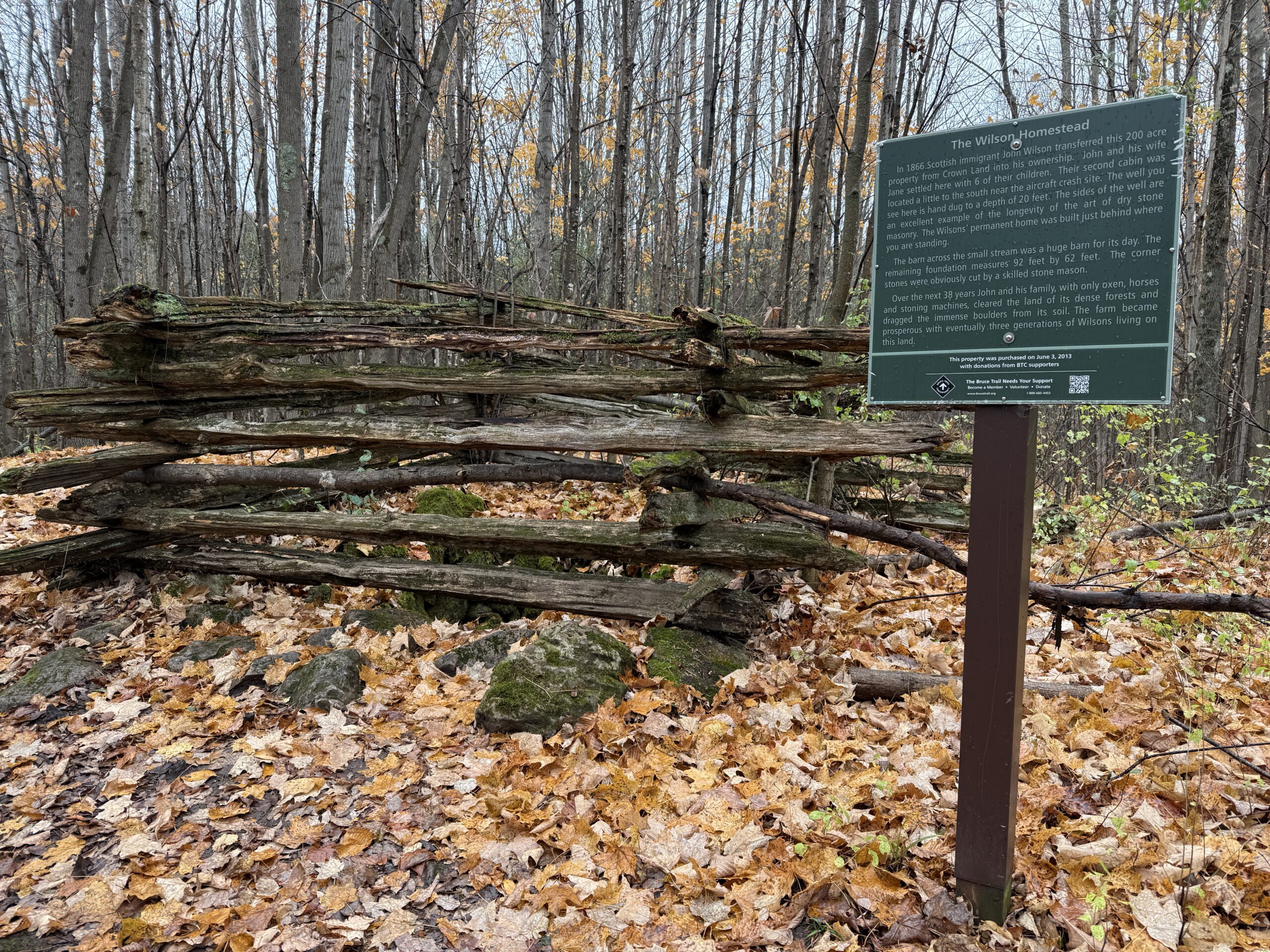
Wednesday Walkers: Silent Valley
https://hikes.brucetrail.org/event/wednesday-walkers-silent-valley/Sorry, the registration cut-off time for this hike has been reached.Not a member? Click here to join today!Hosting Club: Beaver Valley
Location (Google Maps): Meet in the parking area on the road at the end of 2nd Concession South, Map 30, east of km 34.5
Hike Leader(s): Margaret Yaraskavitch Click here to contact the hike leader.
Pace: Medium
Terrain: Moderate, Some rocky footing, Some steep sections
Length of Hike: 5 kmDescription
This hike through Silent Valley is special. Cedar groves, scarp face and large boulders as well as the site of an old farm. Interesting historical features including the remains of a downed airplane. Please bring a drink and, if you’d like, a snack.COVID-19 Precautions Before, During and After your Hike
- Each hiker joining a Bruce Trail Club organized hike must perform a self-screening check before hiking.
Find Ontario’s self-assessment tool here: https://covid-19.ontario.ca/self-assessment/ - If you are experiencing COVID-19 symptoms, stay home.
Other Guidelines
- Arrive 15 minutes before the start of the hike.
- Wear sturdy footwear and appropriate attire for the weather and the terrain.
Hiking poles are a good idea in any season, especially if the terrain is rocky or slippery. In winter, snowshoes or icers/crampons are needed when conditions dictate.
Wearing appropriate clothing and footwear prevents injuries and shows consideration for a safe and positive group hiking experience. - Always carry I.D. and your health card.
- Bring sufficient water and snacks (or lunch if indicated). A minimum of 1L of water is recommended on all hikes, and 3L is recommended for long, challenging hikes in the heat of the summer.
- Bring sunscreen and insect repellent (for spring and summer hikes).
- Bring your own first aid kit.
- Please leave dogs at home.
- Each hiker joining a Bruce Trail Club organized hike must perform a self-screening check before hiking.
- 21November 21, 2024
Urban Walk: Valley View Park Thornhill
https://hikes.brucetrail.org/event/urban-walk-valley-view-park-thornhill-35/Sorry, the registration cut-off time for this hike has been reached.Not a member? Click here to join today!Hosting Club: Toronto
Location (Google Maps): Parking lot at the corner of Bayview Ave, and Sycamore Dr. South of Highway 7
Sycamore Dr. is 3blocks south of highway 7 and 2 blocks north of John Street, parking lot is across plaza of Dollarama and Star boxHike Leader(s): Mohammad Aghamiri Click here to contact Hike Leader(s)
Pace: Moderate (3-4 km/hr)
Terrain: Level 2 (Intermediate – some hills and uneven surfaces, rocks and roots underfoot)
Distance: 7-8 kmDescription
We will explore Valleyview and Maple view parks, and walk along German Mill Creek, for a distance of 7-8 km. Difficulty Level: 2 (Moderate)Hiking Around Jordan
https://hikes.brucetrail.org/event/hiking-around-jordan-9/Sorry, the registration cut-off time for this hike has been reached.Not a member? Click here to join today!Hosting Club: Niagara
Location (Google Maps): Jordan Hollow, across from Boo’s Restaurant
Now known as Shoarishon ParkHike Leader(s): Bill Russell Click here to contact Hike Leader(s)
Pace: Medium
Terrain: ModerateDescription
Hiking various trails in and around Jordan, (Balls Falls, Jim Rainforth Trail and Bailey Bridge through the Village of Jordan.
Smokey Hollow
https://hikes.brucetrail.org/event/smokey-hollow/Sorry, the registration cut-off time for this hike has been reached.Not a member? Click here to join today!Hosting Club: Iroquoia
Category: Thursday Group
Location (Google Maps): City View Park – 2nd driveway off of Dundas on Kerns RdHike Leader(s): Colleen Mabalay Click here to contact Hike Leader(s)
Pace: Medium – 3 to 4 km/hr
Terrain: Dependent on Conditions, Moderate – Some hills and/or some poor footing, Strenuous – Hilly with steep climbs and some poor footing
Distance: Approx 10kmDescription
Parking at City View Park is 2nd driveway off of Dundas on Kerns Rd. Please bring water and snack. There will be a short break to enjoy the view of the falls in Waterdown.This section of the Bruce Trail is twinned with the Tefuye Historical Trail of the Mountains to Sea Greenway (MSTW) in Taiwan.
Rural Rocks and Obese Side Trails
https://hikes.brucetrail.org/event/rural-rocks-and-obese-side-trails/Sorry, the registration cut-off time for this hike has been reached.Not a member? Click here to join today!Hosting Club: Sydenham, Peninsula
Category: General Hike
Location (Google Maps): The Owen Sound Galaxy Cinema parking lot. Meet at the tall “Galaxy Centre” sign next to the traffic lights.Hike Leader(s): Ian Mills
Pace: Medium: 3 to 4 km/h
Terrain: Moderate: Some hills and/or poor footing
Distance: 5 kmDescription
We will be looping clockwise along the Rural Rocks Side Trail through a wonderland of enormous rocks left from a time when this area was the shoreline of an ancient glacial lake. We will also explore the Obese Side Trail which offers challenging terrain. There will be rugged walking along with scrambling around and over rocks. Please wear proper hiking boots/shoes and a stick will be helpful. Let me know if you are interested in lunching in Wiarton afterwards and I can sort reservations. BTC Map # 35. - 22November 22, 2024
9:00 am Niagara-on-the-Lake Tour
https://hikes.brucetrail.org/event/900-am-niagara-on-the-lake-tour-2/Sorry, the registration cut-off time for this hike has been reached.Not a member? Click here to join today!Hosting Club: Niagara
Location (Google Maps): Veterans Memorial Park, park just outside the park on King Street
Hike Leader(s): Robin Garrett Click here to contact Hike Leader(s)
Pace: Medium
Terrain: Easy
Distance: 6-7 kmDescription
Each Friday we will explore different neighbourhoods, trails and parkland throughout Historic Niagara-on-the-Lake.Moderate pace with some weeks entirely on sidewalks and roads while others may include a mix of trails and paved pathways. Great way to build up endurance for longer more strenuous hikes.
Prepare for cooler windy conditions on open parkland and along Lake Ontario and Niagara River trails.
Plan to stay for conversation and a warm cup of coffee or tea at Sweets & Swirls, Community Centre, Niagara Stone Road, NOTL
Rural Rocks/Obese Side Trail and Rural Rootz tour
https://hikes.brucetrail.org/event/rural-rocks-obese-side-trail-and-rural-rootz-tour/Sorry, the registration cut-off time for this hike has been reached.Not a member? Click here to join today!Hosting Club: Sydenham
Category: General Hike
Location (Google Maps): Bluewater Park in Wiarton by the washrooms. From here we will determine carpool options.Hike Leader(s): Cindy Paczkowski Click here to contact Hike Leader(s)
Pace: Leisurely: 3 km/h or less
Terrain: Strenuous: Hilly with steep climbs and some poor footing., There might be muddy sections.
Distance: 4.3 kmDescription
This gorgeous loop hike passes through a wonderland of enormous rocks left from a time when the area was the shoreline of an ancient glacial lake. It is not located off of the main Bruce Trail but is actually located on the other side of Hwy 6 just on the outskirts of Wiarton ( a short drive from the meeting point). The hiking is short in distance but is rugged and requires sturdy footwear and an adventurous spirit. We have the opportunity to visit Rural Rootz, a lovely nature reserve and craft shop following the hike. - 23November 23, 2024
Happy Valley King
https://hikes.brucetrail.org/event/car-hike-hike-of-2-lakes-king-city-13/Sorry, the registration cut-off time for this hike has been reached.Not a member? Click here to join today!Hosting Club: Toronto
Category: Car Hike
Location (Google Maps): Please park along 16th sideroadHike Leader(s): Mohammad Aghamiri Click here to contact Hike Leader(s)
Pace: Moderate (3-4 km/hr)
Terrain: Level 2 (Intermediate – some hills and uneven surfaces, rocks and roots underfoot)
Distance: 14-15 kmDescription
Lets explore beauties of happy valley , the last fall of leaves and the gorgeous look outSchool Bus Hike: Dufferin Section E2E #4 of 4
https://hikes.brucetrail.org/event/school-bus-hike-dufferin-section-e2e-4-of-4/Sorry, the registration cut-off time for this hike has been reached.Not a member? Click here to join today!Trip Information
Departure Time: 08:30
Return to City Time: 18:00
Departure Point: York Mills Bus PickupOptional Items
Hosting Club: Toronto
Category: Bus Hike
Location (Google Maps):Dufferin Hi-land Section km 40.7 to 55.5
Hike Leader(s): Tom Swales, Celia Ho Click here to contact Hike Leader(s)
Pace: Moderate (3-4 km/hr)
Terrain: Hilly, Level 2 (Intermediate – some hills and uneven surfaces, rocks and roots underfoot), Rocky, Variable
Distance: 14.8 kmDescription
Join us on the first four Saturdays of November on a series of bus hikes to complete the Dufferin Hi-Land section. Hikers who complete all four hikes may apply for the Dufferin Hi-Land Club’s pink rose E2E badge ($10.00 Members, $15.00 Non-Members) or their stained glass fundraiser Yellow Ladies Slipper badge ($30.00 – Members Only). The fourth hike in the series will take us from km 40.4 to the Blue Mountain/Dufferin Hi-Land section boundary at Lavender. The trail goes along Black Bank Creek and there are views across the Nottawasaga Low Lands. Anyone is welcome to join one or more of the hikes even if not working on one of the E2E badges. Long Distance Bus Fare applies for this hike. For drivers who wish to meet us at the trailhead, four spots will be reserved – cost $10 includes return shuttle to meeting location – please email the hike leaders for details on how to register as Car Hike – priority for the four spots will be given to hikers intending to join all 4 hikes.Laura Secord 1 of 2
https://hikes.brucetrail.org/event/laura-secord-1-of-2/Sorry, the registration cut-off time for this hike has been reached.Not a member? Click here to join today!This is a Multi-Day Hike
You are signing up for the following dates and times:
2024-11-23 at 09:00
at 09:00Hosting Club: Niagara
Category: Car Pool
Location (Google Maps): Meet at the entrance to Woodend Conservation Area, Taylor Rd, Niagara-on-the-Lake. We will carpool to the start which is the Laura Secord Homestead in NOTLHike Leader(s): Lynskie Click here to contact Hike Leader(s)
Pace: Fast
Terrain: Moderate
Distance: 17.5 kmsDescription
This scenic hike takes us along the route that Laura Secord followed. There are some hills to climb and descend and there is the potential for muddy/slippery terrain so hiking poles are recommended. Please bring your lunch, we’ll stop near Firemen’s Park for it. This is a rain or shine hike so dress appropriately.
Dan Welsh Memorial Hike
https://hikes.brucetrail.org/event/dan-welsh-memorial-hike/Sorry, the registration cut-off time for this hike has been reached.Not a member? Click here to join today!Hosting Club: Iroquoia
Category: Special Event
Location (Google Maps):Park behind Kilbride School 6611 Panton St Burlington
in the large parking lot behind the school.Hike Leader(s): Ruth Moffatt Click here to contact Hike Leader(s)
Pace: Medium – 3 to 4 km/hr
Terrain: Dependent on Conditions, Moderate – Some hills and/or some poor footing
Distance: About 8kmDescription
This is the 5th anniversary of Dan’s passing and we will gather to hike in his memory. Our hike will take us around the River and Ruin side Trail, Cleaver Side Trail and Dan Welsh Side Trail. Please wear plaid if you’d like and share your favourite memory. The Dan Welsh memorial badge, donuts and coke will be complimentary/by donation after our hike back at the parking lot, tailgate style, as Dan would’ve liked. Proceeds to the Iroquoia Bruce Trail Conservancy.
Please bring enough water/snacks for a three hour hike and dress for the forecasted weather. Please bring your icers just in case.
If anyone needs a ride from Grimsby, please reach out to me.Feversham Gorge
https://hikes.brucetrail.org/event/feversham-gorge/Sorry, the registration cut-off time for this hike has been reached.Not a member? Click here to join today!Hosting Club: Blue Mountains
Category: Organized Hike
Location (Google Maps): Tim Hortons, First Street, CollingwoodHike Leader(s): David Little Click here to contact Hike Leader(s)
Pace: Leisurely – 3 km/hr. or less
Terrain: Easy – Mostly flat and usually good footing
Distance: 2 hrsDescription
We will drive to the Feversham Gorge parking lot south of the bridge on County Road 2. We will hike on the trail under the bridge and through the village of
Feversham, cross the bridge then proceed on the Gorge trail. Great views of the Beaver River. The trail continues back to the top of the gorge, returning to the cars. The hike will
include historical information. Bring a snack and water.
High Park to Kipling Station: A walk for memories and histories - 18km
https://hikes.brucetrail.org/event/high-park-to-kipling-station-a-walk-for-memories-and-histories-18km/Sorry, the registration cut-off time for this hike has been reached.Not a member? Click here to join today!Hosting Club: Toronto
Category: Urban Walk
Location (Google Maps): High Park North GateHike Leader(s): Alina Lin; Flicia Devaux, Leila Damband
Pace: Brisk (4-5 km/hr)
Terrain: Flat, Level 1 (Easy – mostly on flat, well maintained trails with hard-packed surface)
Distance: 18 KMDescription
Join me for a walk for late fall sceneries, as well as memories of two TBTC hiking friends who have left us, one in November 2022, and the other in August 2024.Starting from the High Park North Gate, we’ll explore some beautiful spots along the way. We’ll pass by Wayne’s bench in High Park and Wayne’s tree in Sir Casimir Gzowski Park before heading west on the Waterfront Trail. Then, we’ll follow the Humber River Trail northward and make our way to the Village of Islington, where we’ll admire over 20 large murals that recreate scenes from decades past. Our hike will conclude at Kipling Station. Most of the route will be on paved and hard surfaces.
A few notes:
- Dress appropriately for the weather
- Bring water and snacks
- Running shoes are recommended over hiking boots.
- No pets.
Georgian Bluffs - top of Kemble Mountain
https://hikes.brucetrail.org/event/georgian-bluffs-top-of-kemble-mountain/Sorry, the registration cut-off time for this hike has been reached.Not a member? Click here to join today!Hosting Club: Sydenham
Category: General Hike
Location (Google Maps): The Owen Sound Galaxy Cinema parking lot. Meet at the tall “Galaxy Centre” sign next to the traffic lights.Hike Leader(s): Ian Mills
Pace: Medium: 3 to 4 km/h
Terrain: Moderate: Some hills and/or poor footing, There might be muddy sections., There might be sections with water on the trail.
Distance: 9 kmDescription
This hike is a great opportunity for fresh air and exercise. Plan for 3 plus hours on the trail. Please pack a snack or lunch as we will be taking a short break at the halfway point. We will start @142.6 BTC Map # 34 and taking the Main Trail south and looping with the following Side Trails (Mystery Cabin, Don Richards, Coles, Maple Cross Ridge & Nels Maher). Proper hiking footwear is highly recommended and a stick could be helpful.