Categories
- 25November 25, 2023

Bus Hike: Blue Mountains End to End Part V of VI
https://hikes.brucetrail.org/event/blue-mountains-end-to-end-part-v/Sorry, the registration cut-off time for this hike has been reached.Not a member? Click here to join today!Trip Information
Departure Time: 08:00
Return to City Time: 19:00
Departure Point: York Mills Bus PickupOptional Items
Hosting Club: Toronto, Blue Mountains
Category: Bus Hike
Location (Google Maps): Map 22 of the Bruce Trail Reference and Guide. Km 21.9 to km11.9Hike Leader(s): George Lennon and Michael Humpage Click here to contact Hike Leader(s)
Pace: Moderate
Terrain: Variable
Distance: 10kmDescription
Bus departs 10 York Mills Rd at 8:00 AM and Major Mackenzie Dr and HWY 400 Park and Ride at 8:20 AM. If you wish to be picked up at the Major Mackenzie Dr and HWY 400 Park and Ride, please email hike leaders. Please arrive 15 minutes before departure. The bus waits for no one.Our hiking will resume at km 21.9 where we left off in the Nottawasaga Bluffs Conservation Area. We will pass by the ruins of a settlers’ lime kiln before entering mature cedar forests and then immature forests. Glaciers have deposited the spoon-shaped mounds of sand and gravel, called drumlins, that are on the left of the trail. Bring lunch and water. We will bid farewell to each other for the winter with a stopover in Shelburne on the way home to Toronto, and we will look to complete our end-to-end next spring.
If you are planning to order an end-to-end badge for the Blue Mountains Section please type ‘Yes’ in the Additional information Field when you register. I will collect from you your log and the $5 to pay for the badge on the hike when we hold the last of our hikes in this series next spring. I will email notice of our final hike to hikers on these Blue Mountains bus hikes when we have set the date next spring.
** Hikers are required to bring a mask and wear it on the bus. Masks must fit properly and cover the nose, mouth and chin. For the highest level of protection against Covid-19, respiratory viruses or the flu, KN95 or N95 masks are recommended. **
Car Hike: Bethesda Trail Richmond Hill
https://hikes.brucetrail.org/event/car-hike-bethesda-trail-richmond-hill-13/Sorry, the registration cut-off time for this hike has been reached.Not a member? Click here to join today!Hosting Club: Toronto
Category: Car Hike
Location (Google Maps): Meet at Bethesda Trail Head Parking on Bethesda Sideroad off Bayview Avenue, across from Lake Wilcox. This parking lot is free.Hike Leader(s): Mohammad Aghamiri Click here to contact Hike Leader(s)
Pace: Moderate
Terrain: Variable
Distance: 14-17KMDescription
Join us to explore Jefferson Forest and Bond lake ,Please bring hiking poles, proper closing and shoes and lots of water,
Please carefully read safety procedures during the hike:
1-Hikers must stay between the leader and the sweep.
2-Hikers must advise the leader or the sweep if they wish to leave the group.
3- Hikers must follow the whistle instructions: 1 blast- stay where you are; 2 blasts come to the leader; 3 blasts – come to the leader quickly.
4-Hike leader may request volunteers to stop at trail intersections, they need to help hikers to the direction the group walk and wait till they see the sweep .
5-Hikers have to make sure they can see the persons behind and in front of them.

Witch of Cave Springs Hike - Last chance for this year's Screaming Tunnel Badge!
https://hikes.brucetrail.org/event/witch-of-cave-springs-hike-last-chance-for-this-years-screaming-tunnel-badge/Sorry, the registration cut-off time for this hike has been reached.Not a member? Click here to join today!Hosting Club: Niagara
Category: In and Out
Location (Google Maps): Meet at Quarry Rd parking lot in BeamsvilleHike Leader(s): Angela Lytle Click here to contact Hike Leader(s)
Pace: Medium
Terrain: ModerateDescription
Join us for the final Cave Springs Witch Hunt hike of the season. This hike can be used towards earning the Screaming Tunnel badge.Discover the history of the 19th Century Quarry Pioneers and the Witch of Cave Springs
Please arrive by 8:45 so we can check in and be ready to head out at 9 am.
The meeting place is on Quarry Rd in Beamsville just next to the Bruce Trail. Google maps link: https://maps.app.goo.gl/Nr4gM9muiSt8DiUT8
The path to Cave Springs is quite rocky and has some hills. We recommend using hiking poles and wearing good hiking shoes. Carry water and dress for changeable weather.
The hike includes some local lore, but there’s a lot more than we can cover while hiking!
You can read more about the Witch of Cave Springs at this link, including reviewing a copy of “The Mystique of Cave Springs” by Margaret Reed: https://drive.google.com/drive/folders/1D1wreBwDD3PvD6YfqUGh1AkyJCPjhggf?usp=sharing
9:00 DeCew to Morningstar Mill
https://hikes.brucetrail.org/event/900-decew-to-morningstar-mill-2/Sorry, the registration cut-off time for this hike has been reached.Not a member? Click here to join today!Hosting Club: Niagara
Category: In and Out
Location (Google Maps): DeCew House, 2350 DeCew Rd, Thorold.Hike Leader(s): Debbie Demizio Click here to contact Hike Leader(s)
Pace: Medium
Terrain: ModerateDescription
This hike follows the main trail along Moody Lake to the Morningstar Mill side trail, past the DeCew Falls to Morningstar Mill. Total 5.3 kmsWasaga Dunes
https://hikes.brucetrail.org/event/wasaga-dunes/Sorry, the registration cut-off time for this hike has been reached.Not a member? Click here to join today!Hosting Club: Blue Mountains
Category: Register in person the morning of hike.
Location (Google Maps): Hike meets at Tim Horton’s, Mosley Street, Wasaga BeachHike Leader(s): Michael Treuman Click here to contact Hike Leader(s)
Pace: Medium – 3 to 4 km/hr
Terrain: Moderate – Some hills and/or some poor footing
Distance: 6 kmDescription
We will meet at Tim Hortons in Wasaga Beach – take Beachwood Drive to Mosley Street and Tim Horton’s is on the right just before the bridge). We will hike over the Dunes and along the river. The hike is partially on the Ganaraska trail. Bring a snack and water.
Dan Welsh Memorial Hike
https://hikes.brucetrail.org/event/dan-welsh-memorial-hike-2/Sorry, the registration cut-off time for this hike has been reached.Not a member? Click here to join today!Hosting Club: Iroquoia
Category: Special Event
Location (Google Maps): Park behind Kilbride School 6611 Panton St Burlington
in the large parking lot behind the school.Hike Leader(s): Ruth Moffatt Click here to contact Hike Leader(s)
Pace: Medium – 3 to 4 km/hr
Terrain: Moderate – Some hills and/or some poor footing, Strenuous – Hilly with steep climbs and some poor footing
Distance: About 8kmDescription
This is the 4th anniversary of Dan’s passing and we will gather to hike in his memory. Our hike will take us around the River and Ruin side Trail, Cleaver Side Trail and Dan Welsh Side Trail. Please wear plaid if you’d like and share your favourite memory. Donuts and coke will be complimentary/by donation after our hike back at the parking lot, tailgate style. Proceeds to the Bruce Trail Conservancy.
Please bring enough water/snacks for a three hour hike and dress for the forecasted weather. Please bring your icers just in case.
Dan Welsh memorial badges will be available for $20 each. It is hoped that eventually there will be a memorial award in his memory.
If anyone needs a ride from Grimsby, please reach out to me.Headwaters Hike Series (North) - # 3 of 3 - Pretty River (Map 23, Blue Mountains Section)
https://hikes.brucetrail.org/event/headwaters-hike-series-north-3-of-3-pretty-river/Sorry, the registration cut-off time for this hike has been reached.Not a member? Click here to join today!Hike open to BTC Members only.
Hosting Club: Dufferin Hi-Land
Category: General Hike
Location (Google Maps): Meet at the Snowmobile Parking Lot, 63597 Pretty River Rd north of Duntroon.Hike Leader(s): Margery Cruise,Susan Ford Click here to contact Hike Leader(s)
Pace: Medium
Terrain: Moderate, Strenuous
Distance: 9.9Description
We will walk 380 meters on Pretty River road to the trail start at km 46.8 (Map 23, Blue Mountains Section). We will follow the main trail to the John Haigh Side Trail follow it to the highest point of the Bruce trail. Then we turn around, retrace our steps and follow Pretty River Side Trail. When it joins the main trail, we will follow it back to Pretty River Road and walk east to the parking lot.Directions: From CR 124 and HW 89, north on CR 124 to Singhampton, continue east on CR 124 and then north to Sideroad 33 and 34 Nottawasaga. Turn left and look for Snowmobile Parking Lot.
This is a series of 7 hikes: 3 Headwaters North and 4 Headwaters South. Hikers completing all 7 hikes in this series will be eligible to purchase a Headwaters Hike Series Badge (when available) from Dufferin Hi-Land BTC. The North section is offered in the Fall of 2023, while the south section will be offered in the Spring of 2024.
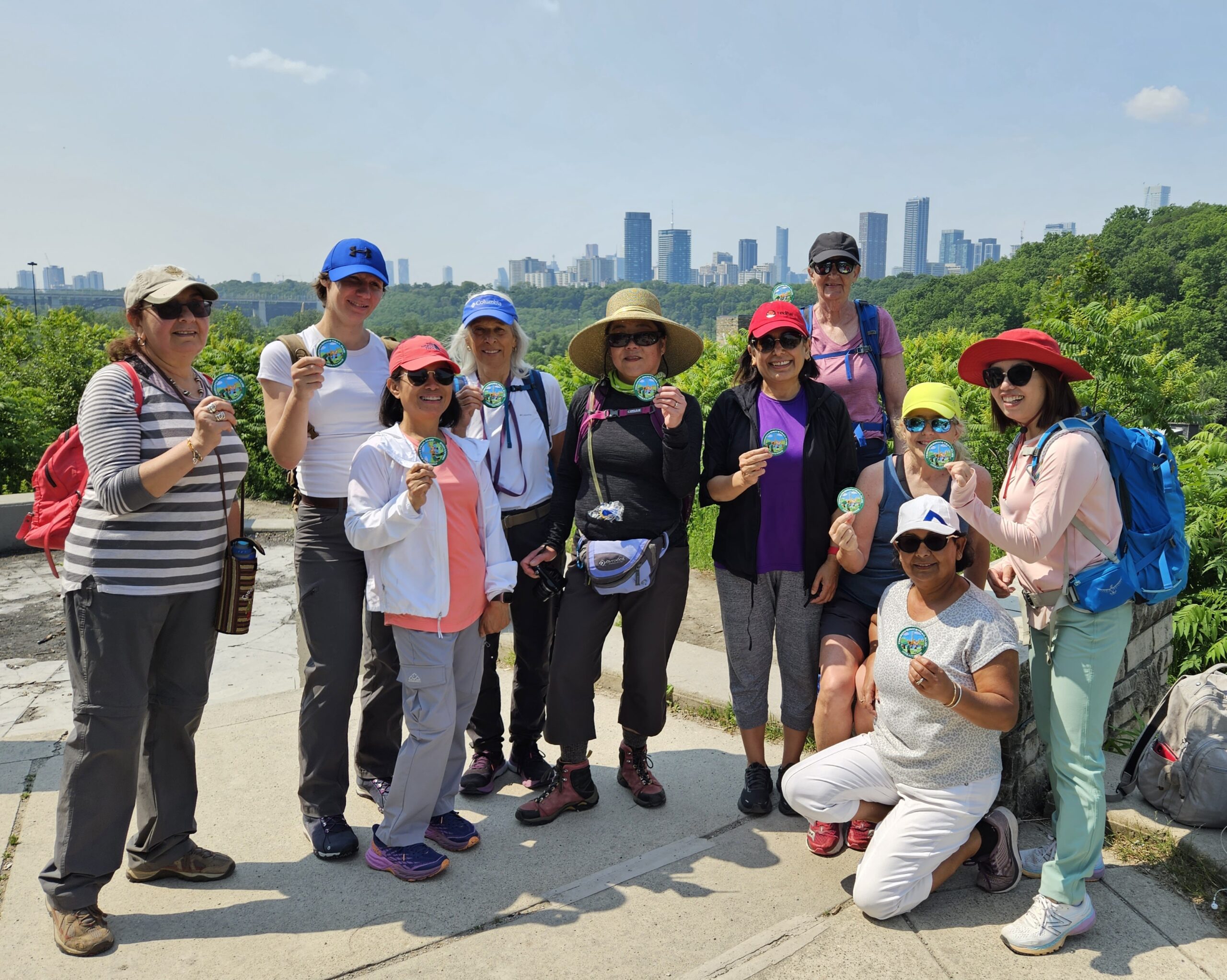
#1/4 Toronto Urban Badge Hike - 18km
https://hikes.brucetrail.org/event/urban-walk-1-4-toronto-urban-badge-hike-18km/Sorry, the registration cut-off time for this hike has been reached.Not a member? Click here to join today!Hosting Club: Toronto
Category: Urban Walk
Location (Google Maps): Evergreen Brick Works – TTC 28 Terminal. TTC bus 28 connects Davisville Station and Evergreen Brick Works.Hike Leader(s): Alina Lin Click here to contact Hike Leader(s)
Pace: Moderate
Terrain: Flat
Distance: 19 KMDescription
Let’s explore the city in winter and build up our appetites for the holiday season while earning the unique Toronto Urban Hike Badge.To qualify for the badge, we will embark on a 74 KM loop (map: https://onthegomap.com/s/c2c1hf3n ) through a series of four Saturday hikes scheduled for Nov 25 (18 KM), Dec 2 (17 KM), Dec 9 (23 KM), and Dec 16 (20 KM). On both Nov 25 and Dec 2, we will conclude our hikes at Leslie & Sheppard, with the option to visit the Mountain Equipment Company North York store for an introduction to winter hiking gear.
Please bring hot beverage and snacks/light lunch for our journey. We will take short breaks for restroom stops and lunch at suitable locations along the trails. The majority of the route consists of paved paths, so running shoes are recommended over hiking boots.
Badges by request will be presented at the last hike. The cost of the badge is $5 for members and $15 for non-members.
Harrison Park - Arboretum Loop
https://hikes.brucetrail.org/event/harrison-park-arboretum-loop/Sorry, the registration cut-off time for this hike has been reached.Not a member? Click here to join today!Hosting Club: Sydenham
Category: Health & Nature Hike
Location (Google Maps): Parking lot by the Harrison Park Inn in Harrison Park, 137 2nd Avenue East, Owen Sound (Map 32)Hike Leader(s): Danuta Valleau Click here to contact Hike Leader(s)
Pace: Leisurely: 3 km/h or less
Terrain: Easy: Mostly flat and good footing.
Distance: about 4 kmDescription
We will cross the bridge together and walk south along the river, taking the side trail into the Grey Sauble Conservation Authority and tour the arboretum before retracing our steps via the river. Option to have lunch at the Harrison Park Inn afterwards. Please contact hike leader if interested. Bring walking poles if you have them. Supportive footwear (or snow shoes if conditions are right). Bring your own water bottle. If you are unable to register, please call or text the hike leader at 519-378-5630.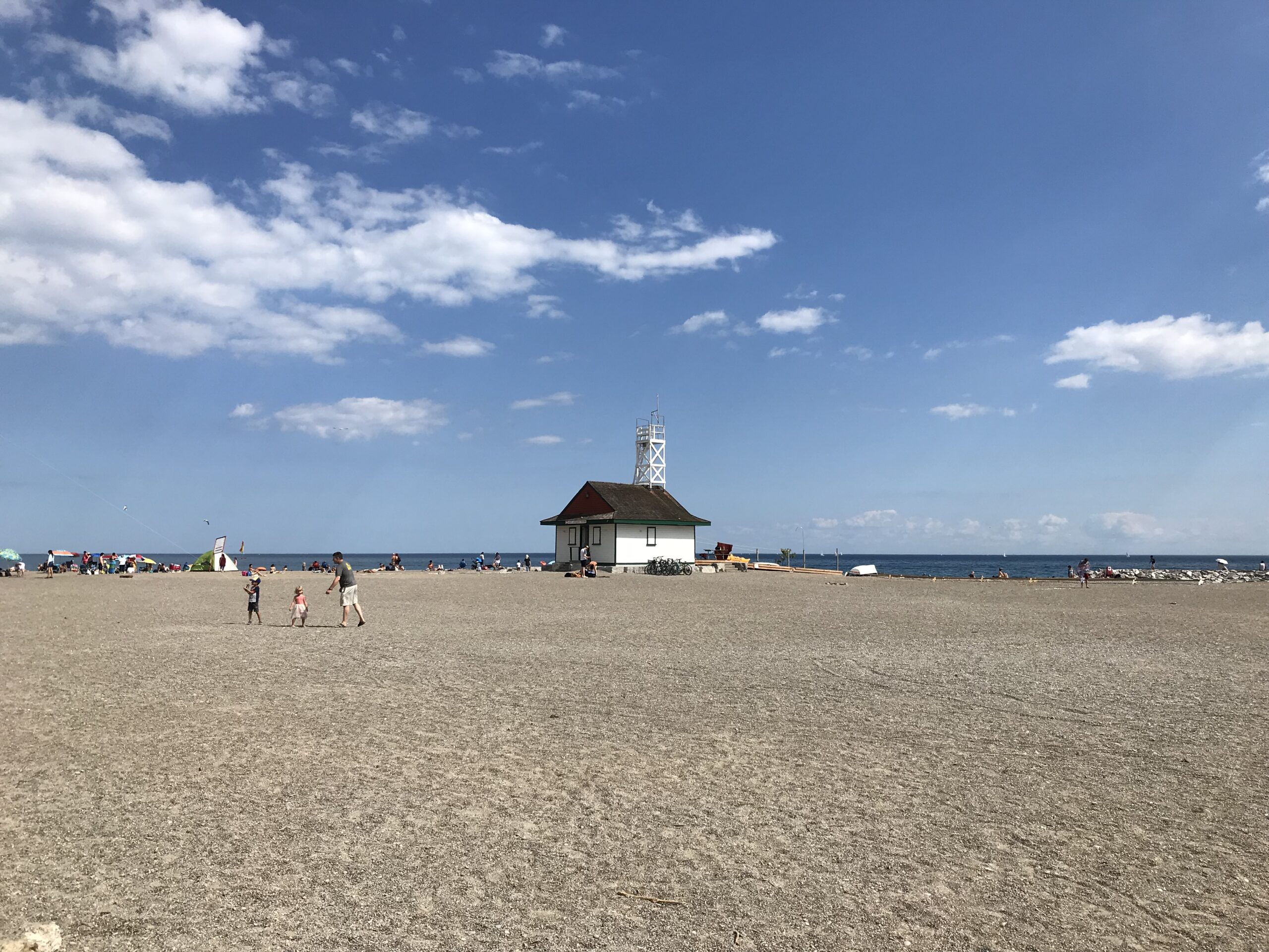
Urban Walk: Toronto Beach Walk and Glen Stewart Ravine
https://hikes.brucetrail.org/event/urban-walk-toronto-beach-walk-and-glen-stewart-ravine/Sorry, the registration cut-off time for this hike has been reached.Not a member? Click here to join today!Hosting Club: Toronto
Category: Urban Walk
Location (Google Maps):Meet at the Toronto Public Library, Beaches Branch, 2161 Queen Street East, Toronto, M4L 1J
Hike Leader(s): Jeanette Vincen Click here to contact Hike Leader(s)
Pace: Moderate
Terrain: Flat, Other (Refer to Description)
Distance: 10kmDescription
Meet at the Toronto Public Library, Beaches Branch. We will walk the boardwalk and easy pathways that wind along the variety of beaches from Silver Birch Avenue to Ashbridges Bay Park. It will be an out and back route, with lots of views into Lake Ontario, you will see many points of interest, parks, Kew gardens, including the historic Leuty Lifesaving Station and the historic architecture of the Ashbridges Bay Wastewater Treatment Plant, the R.C. Harris Filtration Plant. I have frequent visits to this area and we will make our way across Queen St. to walk the Glen Stewart Ravine a nice ascent, taking in beautiful picturesque natural areas along Ames creek, meandering on elevated boardwalks and stair cases and then descending the area on some of the pleasing neighourhood streets back to our start at the Beaches Branch Library. A pleasing area that offers a little something for everyone!If you want something a little shorter you can drop-out at various areas along the way.No dogs. Good footwear, snacks/lunch and water. Dress according to the weather conditions.