|
Sun | Mon | Tue | Wed | Thu | Fri | Sat |
|---|
May | 1 | 2 | 3 | 4 | 5 | 6 - Dr. Philip Gosling Memorial Hike & Founders’ Footpath Plaque Unveiling
9:30 AM-12:00 PM 06/06/2026 https://hikes.brucetrail.org/event/dr-philip-gosling-memorial-hike-founders-footpath-plaque-unveiling/2026-06-06/  Click here for more information or to register Hosting Club: Caledon Hills
Category: General
Location (Google Maps): Akela and Scouters Heather and Ross Hamlin Nature Reserve at Riverside Woods
713377 1st Line EHS, Mono
Google GPS Coordinates: 43.959916, -80.070494 Driving Directions:
From ON-9, head north onto 2nd Line EHS for 3 kilometres. Turn left onto Side Road 5 for 1.5 kilometres. Turn right onto 1st Line EHS for approximately 1 kilometre. Continue straight into the parking lot. From ON-10, head east on Hockley Road/Dufferin County Road 7 for 1 kilometre. Continue straight onto Side Road 5 for 1.5 kilometres. Turn left onto 1st Line EHS for approximately 1 kilometre. Continue straight into the parking lot. Hike Leader(s): Sandy Green Click here to contact Hike Leader(s) Pace: Brisk – 4 to 5 km/hour, Leisurely – 3 km/hour or less
Terrain: Easy – mostly flat and usually good footing
Distance: 2 or 3 kilometres Description
Bruce Trail members and friends are invited to gather in nature to honour the life, vision, and legacy of Dr. Philip Gosling, Founder of the Bruce Trail. A time of reflection and the unveiling of the Founders’ Footpath commemorative plaque will be led by Michael McDonald, CEO of the Bruce Trail Conservancy, followed by a guided walk along the footpath, and a time of fellowship and refreshments.
- International Trails Day Celebration and Saturday Shorts Hike
2:00 PM-3:30 PM 06/06/2026 https://hikes.brucetrail.org/event/international-trails-day-celebration-and-saturday-shorts-hike/2026-06-06/  Click here for more information or to register Hosting Club: Caledon Hills
Category: General
Location (Google Maps): Meet in the Caledon Public Library – Alton Branch
35 Station Street Driving Directions: From ON-10, turn west on Charleston Sideroad/Peel Regional Road 24 for 4 kilometres. Turn right/north onto 3 LineW/Main Street/Peel Regional Road/136 for 4 kilometres. Turn right onto Station Street. The library is on the right side. Hike Leader(s): Sandy Green Click here to contact Hike Leader(s) Pace: Leisurely – 3 km/hour or less
Terrain: Easy – mostly flat and usually good footing
Distance: 5.5 kilometres Description
Plan to join our local celebration of International Trails Day – promised fun for all. Come to the library early (1:00 pm to 2:00 pm) to learn more about local trails, healthy lifestyles, and volunteering through hands-on activities, conversation, giveaways, and fabulous door prizes. A loop around the biodiverse Alton Grange Property will offer many exciting opportunities for nature sightings. Bring a beverage and snack to keep you energized on the trail. This special hiking event is brought to you by the Caledon Public Library, Caledon Hills BTC, Alton Grange Association, and WILD Outside Youth Leadership Group.
|
7 - Caledon Hills E2E in 4 – Hike #3
8:30 AM 06/07/2026 https://hikes.brucetrail.org/event/caledon-hills-4-hike-e2e-3/2026-06-07/  Click here for more information or to register Hosting Club: Caledon Hills
Category: End-to-End
Location (Google Maps): Roadside parking – km 35.0 on Coolihans Sideroad, east of where the trail crosses the road. Hike Leader(s): Dan Patterson Click here to contact Hike Leader(s) Pace: Medium – 3 to 4 km/hour
Terrain: Strenuous – hilly with steep climbs and some poor footing
Distance: 19.1 km Description
Meet at Coolihans Side Rd., roadside parking. We will shuttle to Willoughby Rd. at the end of Escarpment Sideroad to start our hike. Bring sufficient water, electrolytes, bug spray, sun glasses, lunch and snacks. Poles are helpful. Volunteers will be required to participate in shuttling and driver return as well as a sweep.
| 8 | 9 - Terra Cotta Loop Hike
9:30 AM-12:00 PM 06/09/2026 https://hikes.brucetrail.org/event/terra-cotta-loop-hike-2/2026-06-09/ 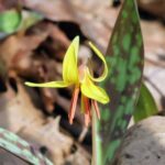 Hike open to BTC Members only. Click here for more information or to register Hosting Club: Caledon Hills
Category: General
Location (Google Maps): Terra Cotta Conservation Area (entry fee $8 per person at the gate)
14452 Winston Churchill Blvd., Halton Hills Hike Leader(s): Jane Hull Click here to contact Hike Leader(s) Pace: Medium – 3 to 4 km/hour
Terrain: Moderate – some hills and/or some poor footing
Distance: 6.5 km Description
Join us for a late spring loop hike through Terra Cotta Conservation area. We will hike several of the trails (moderate difficulty with some hilly sections/roots/rocks) and may spot some remaining spring wildflowers, or see some painted turtles in the wetland ponds. Bring your choice of hydration and snacks.. Hiking boots/shoes required. Participants will be notified the night before if the hike must be cancelled due to inclement weather.
- Forks of the Credit
9:30 AM-2:00 PM 06/09/2026 https://hikes.brucetrail.org/event/forks-of-the-credit-6/2026-06-09/ Click here for more information or to register Hosting Club: Caledon Hills
Category: Tuesday Hikers
Location (Google Maps): Mississauga Rd. intersection with Elora-Cataract Trailway.
Driving direction: From Highway 401, north on Mississauga Rd., pass through Belfountain village, after crossing Cataract Rd. and Elora-Cataract Trailway, park on either side of the road.
Alternate direction: North on Highway 410, continue on Highway 10, at Caledon Village, left on Charleston Sideroad (24), left on Mississauga Rd., drive 2 km to the roadside parking. Hike Leader(s): Mohammad Shafiq Click here to contact Hike Leader(s) Pace: Medium – 3 to 4 km/hour
Terrain: Moderate – some hills and/or some poor footing
Distance: 11 km Description
Will enter Forks of the Credit Conservation Area using Elora-Cataract Trailway and hike main Bruce Trail, Mill Pond Trail and parts of conservation trails.
Bring water and snack; poles are recommended.
Optional refreshment stop at one of the cafes nearby – more information on the hiking day.
| 10 | 11 | 12 | 13  Sydenham Stained Glass Badge E2E in 8 Hikes Sydenham Stained Glass Badge E2E in 8 Hikes 8:00 AM-3:00 PM 06/13/2026 https://hikes.brucetrail.org/event/sydenham-stained-glass-badge-e2e-in-8-hikes/2026-06-13/  This is a Multi-Day HikeYou are signing up for the following dates:
2026-06-13, 2026-06-14, 2026-06-20, 2026-06-21, 2026-06-27, 2026-06-28, 2026-07-04, 2026-07-05 Click here for more information or to register Hosting Club: Caledon Hills, Sydenham
Category: End-to-End
Location (Google Maps): Meet at a parking lot off of 6th Concession Road south. Hike Leader(s): Lily Li Click here to contact Hike Leader(s) Pace: Brisk – 4 to 5 km/hour, Medium – 3 to 4 km/hour
Terrain: Moderate – some hills and/or some poor footing
Distance: 21 km Description
Earn the Hart’s Tongue Stained Glass / Fundraiser badge, which is part of the collectable Bruce Trail Clubs stained glass-themed fundraiser set. This is a special series of 8 hikes in 4 weekends to complete the Sydenham section of 166 kms. Hike distances range from 18 to 23 km each day with about 4 km/hour pace. The hike is intended to be moderate to brisk. Please dress according to the weather presented that day. Bring at least 2 liters of water and electrolytes, lunch, snack, hat, sunscreen and bug spray for the long day of hike. This is a car shuttle hike. Please have your vehicle ready as everyone will be taking a turn either to drive to the start point of our hike or to get our drivers back at the end of the day.
- Sydenham Lindenwood Road to Graham’s Hill
8:45 AM-3:30 PM 06/13/2026 https://hikes.brucetrail.org/event/sydenham-lindenwood-road-to-grahams-hill/2026-06-13/ 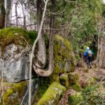 Click here for more information or to register Hosting Club: Caledon Hills
Category: General
Location (Google Maps): Meet at Bruce Trail Lindenwood Parking lot, 125.7 km, Bruce Trail Reference Guide Edition 31. Hike Leader(s): Dan Patterson Click here to contact Hike Leader(s) Pace: Medium – 3 to 4 km/hour
Terrain: Moderate – some hills and/or some poor footing
Distance: 22.2 km Description
First stage in a two stage hike to Wiarton where Sydenham meets the Peninsula Section. We will shuttle to Graham’s Hill Rd. and hike 22.2 km back. Bring sufficient water, lunch, snacks, bug repellent. Hiking poles may be helpful in this area.
- Mono Cliffs Provincial Park Scenic Hike
9:30 AM-2:00 PM 06/13/2026 https://hikes.brucetrail.org/event/mono-cliffs-provincial-park-scenic-hike/2026-06-13/  Click here for more information or to register Hosting Club: Caledon Hills
Category: Nature Walks
Location (Google Maps): •Do not go to the Mono Cliff Provincial Park Parking lot on 3rd Line EHS, this is the wrong place.
•Meet the hike leader at the Mono Centre parking lot. The entrance to the parking area is on your right, just before a tennis court.
. Please arrive 15 minutes before the start time. Hike Leader(s): Priyantha(Pri) Amarasinghe Click here to contact Hike Leader(s) Pace: Leisurely – 3 km/hour or less
Terrain: Moderate – some hills and/or some poor footing
Distance: 10 km Description
This loop hike is one of the more popular forest adventures in Mono Cliffs. Its trail system offers a great deal of diversity, featuring marshes, dry woods, ponds, and rolling hills that lead to several excellent viewpoints. Among the several trails within the park, we take on a combination of the most scenic sections, including the main Bruce Trail, the Clifftop Side Trail with stops at the wooden steps going down to the escarpment valley for pictures and walking back up, and continue hiking further north to the Lookout deck for a good view of the plain below. Next stop is at Scenic Rock Cliffs/Jacobs Ladder (there are 45 steel steps to reach the bottom deck for beautiful rock cliff pictures and go back up the same way). We then hike further north past McCarston’s Lake onto the Lookout Trail for a scenic view of the highest point in the park, at 507m/1607 ft, before joining the Walter Tovell Side Trail, from where we hike back to the Mono Centre parking. Most of the path is flat, grassy trail with a few rocky inclines and those metal and wooden steps as mentioned above. Must haves Good, well-broken hiking shoes, bug spray, water, a lunch snack, personal hygiene stuff/garbage bag to carry any food waste/wrappings and ideally a wide-brimmed sun hat or a cap to protect from the midday heat. Trekking poles are recommended.
|
14 - Pre-Film Fundraiser Hike
10:00 AM-11:30 AM 06/14/2026 https://hikes.brucetrail.org/event/pre-film-fundraiser-hike/2026-06-14/
| 15 | 16 - Limehouse Loop
9:30 AM-12:00 PM 06/16/2026 https://hikes.brucetrail.org/event/limehouse-loop-3/2026-06-16/ Click here for more information or to register Hosting Club: Caledon Hills
Category: Tuesday Hikers
Location (Google Maps): Meet at Limehouse Conservation Area, west of km 20.3 at the baseball diamonds. Access from 5th Line, just southeast of the village of Limehouse. Hike Leader(s): Ralph Shapiro Click here to contact Hike Leader(s) Pace: Medium – 3 to 4 km/hour
Terrain: Moderate – some hills and/or some poor footing
Distance: 9 kilometres Description
Lovely loop hike using main trail and a couple of side trails.
- Island Lake – Orangeville
9:30 AM-2:00 PM 06/16/2026 https://hikes.brucetrail.org/event/island-lake-orangeville-6/2026-06-16/ Click here for more information or to register Hosting Club: Caledon Hills
Category: Tuesday Hikers
Location (Google Maps): Meet at Vicki Barron Lakeside Trail Parking.
After driving through Orangeville traffic lights on Highway 10, turn right on Hockley Rd., keep straight onto Sideroad 5, turn right on Hurontario Street to the car parking close to the lake. Hike Leader(s): Mohammad Shafiq Click here to contact Hike Leader(s) Pace: Medium – 3 to 4 km/hour
Terrain: Easy – mostly flat and usually good footing
Distance: 9 – 10 km Description
Will hike around Island Lake, may take diversion into the side trails for a total of 9-10 km completing a loop around the lake.
Bring hydration drink and snack.
Keep sunscreen and bugs spray in your bag.
| 17 | 18 | 19  Dog-Friendly Hike: Hockley Valley Dog-Friendly Hike: Hockley Valley 8:30 AM-3:00 PM 06/19/2026 https://hikes.brucetrail.org/event/car-hike-dog-friendly-caledon-side-trail-hikes-2/2026-06-19/ Click here for more information or to register Hosting Club: Toronto, Caledon Hills
Category: Car Hike
Location (Google Maps): Hockley Valley South Hike Leader(s): Lindita Kalo Click here to contact Hike Leader(s) Pace: Moderate (3-4 km/hr)
Terrain: Challenging, Level 2 (Intermediate – some hills and uneven surfaces, rocks and roots underfoot), Variable
Distance (km): 10km Description
Join me on the series of dog friendly to complete Caledon side trail challenge. Hockley Valley main Bruce trail and side trail.
Those hikes have some hills. We will keep moderate speed. For those joining both hikes be true to your abilities of hiking long distance. An email will be send to register hikers before the day.
| 20 - Car Hike: Hockley Valley, Map 18
10:00 AM-3:30 PM 06/20/2026 https://hikes.brucetrail.org/event/car-hike-hockley-valley-map-18-5/2026-06-20/ Click here for more information or to register Hosting Club: Toronto, Caledon Hills
Category: Car Hike
Location (Google Maps): Hockley Valley Provincial Nature Reserve Hike Leader(s): Al Brown Click here to contact Hike Leader(s) Pace: Moderate (3-4 km/hr)
Terrain: Challenging, Hilly, Level 2 (Intermediate – some hills and uneven surfaces, rocks and roots underfoot)
Distance (km): 14 km Description
We will complete a loop hike through the nature preserve along one of the hilliest sections of the Trail. After the hike those interested can meet for refreshments in the local area. To get to the meeting point drive north on Hwy 10 past Orangeville to Hockley Road. Turn right and go about 6 km to the parking area. It is across the road from the Black Birch restaurant.
|
21 - Caledon Hills E2E in 4 – Hike #4
8:45 AM-2:30 PM 06/21/2026 https://hikes.brucetrail.org/event/caledon-hills-e2e-in-4-hike-4/2026-06-21/  Click here for more information or to register Hosting Club: Caledon Hills
Category: End-to-End
Location (Google Maps): Roadside parking southwest of km 48.4 at Boston Mills Rd. just west of the Mississauga Rd. intersection. 866 Boston Mills Rd., Terra Cotta, ON L7C 0L7, Canada Hike Leader(s): Dan Patterson Click here to contact Hike Leader(s) Pace: Medium – 3 to 4 km/hour
Terrain: Strenuous – hilly with steep climbs and some poor footing
Distance: 18.34 km Description
Meet at Boston Mills Road west of Mississauga Road at 8:45 a.m.. We will shuttle to Willoughby Road at 9:00 a.m. This is an End-to-End hike series to complete the Caledon section of the Bruce Trail in 4 hikes. We will be hiking from the north end to the south end. Join for all or as many hikes as desired – you will need to register for each hike in the series which will take place on the following dates: May 17, 24, June 7, 21 Since this is a group hike, please consider your fitness level before registering. We will be walking at a pace of 3 km – 4 km per hour and hikers will need to keep up with the person in front of them for the duration of the hike. The hike series will also involve car shuttles and every hiker is expected to participate as drivers. Weather conditions can be variable, dressing in layers is recommended. Hiking boots are required and hiking poles are strongly recommended. Bring plenty of fluids, electrolytes and a snack. This section is challenging with many hills.
| 22 | 23 - City View Park, Burlington, Map 9.
9:30 AM-2:00 PM 06/23/2026 https://hikes.brucetrail.org/event/city-view-park-burlington-map-9-8/2026-06-23/ Click here for more information or to register Hosting Club: Caledon Hills
Category: Tuesday Hikers
Location (Google Maps): City View Park South Lot, Burlington.
From Highway 403 going west, turn right on Brant Street, left on Dundas Street, left on Kerns Rd., take second turn left into City View Park to the parking lot. Hike Leader(s): Mohammad Shafiq Click here to contact Hike Leader(s) Pace: Medium – 3 to 4 km/hour
Terrain: Moderate – some hills and/or some poor footing
Distance: 11 km Description
From City View Park will connect with main Bruce Trail and hike to Smokey Hollow waterfall, also hike Kings ST and/or Eric Best ST on the way. After snack break will trace back our steps and return to parking.
Bring water, snack for refreshment break at Smokey Hollow.
Dress for the weather, poles are recommended.
Optional refreshment stop after hike at Kopper Kettle in Waterdown.
| 24 - Waterloo Region Wednesday Walks The Hydrocut
8:45 AM-12:15 PM 06/24/2026 https://hikes.brucetrail.org/event/waterloo-region-wednesday-walks-the-hydrocut/2026-06-24/  Click here for more information or to register Hosting Club: Caledon Hills
Category: General
Location (Google Maps): We will meet at the Walmart/Winners parking lot located in the Boardwalk area off of Glasgow Street. Hike Leader(s): Dan Patterson Click here to contact Hike Leader(s) Pace: Medium – 3 to 4 km/hour
Terrain: Moderate – some hills and/or some poor footing
Distance: 13 km Description
Join the Waterloo Wednesday Walkers as we continue to explore Waterloo Region trails. Today is a special treat: The Petersburg Hydrocut. We will meet at the Walmart/Winners parking lot located in the Boardwalk area off of Glasgow Street. We will walk to the Glasgow Street Hydrocut Trailhead, then follow the actual hydrocut on the ultility vehicle road (warning: may be rough in places) where we will connect with the Synder’s Road part of the Hydrocut Mountain Biker complex. We will explore the complex on the main multi-use trail. (Please stay off the narrow side trails. These are reserved for bikers and hiking on them can be dangerous). Bring sturdy boots, snacks, lunch, insect repellent, electrolytes, an explorer’s curiousity and a “can-do” attitude. Poles may be helpful but not required.
| 25 | 26 | 27 - Sydenham Graham Hill Road to Bluewater Park
8:45 AM-3:30 PM 06/27/2026 https://hikes.brucetrail.org/event/sydenham-graham-hill-road-to-bluewater-park/2026-06-27/  Click here for more information or to register Hosting Club: Caledon Hills
Category: End-to-End
Location (Google Maps): Meet at Bluewater Park, 502 George St., Wiarton, ON. We will shuttle to Graham’s Hill Rd 44.764911, -80.944925 and hike back. Hike Leader(s): Dan Patterson Click here to contact Hike Leader(s) Pace: Medium – 3 to 4 km/hour
Terrain: Strenuous – hilly with steep climbs and some poor footing
Distance: 22.2 km Description
Experience Skinner’s Bluff, Big Bay and the walk to Bluewater Park on gorgeous Colpoy’s Bay. From our meeting point we will shuttle to Graham’s Hill Road and enjoy one of the most spectacular hikes on the Bruce! Bring sufficient water, lunch, snacks, bug repellent. Hiking poles may be helpful. Note: this section includes Colpoy’s Range Road which is often very wet. I will be wearing high rise boots.
- Celebrate Pride Together in Nature
10:00 AM-12:00 PM 06/27/2026 https://hikes.brucetrail.org/event/celebrate-pride-together-in-nature/2026-06-27/  Click here for more information or to register Hosting Club: Caledon Hills
Category: Nature Walks
Location (Google Maps): Bruce Trail parking Lot at Riverside Woods, 713377 1st Line EHS, Mono.
Driving directions:
From Hwy # 10 north of Orangeville, turn east on to Hockley Rd. Drive for 1.1 km. Continue straight onto Side Road 5 for 1.6 km. Turn left onto 1st Line EHS for 900 meters. Continue straight into the parking lot. ***DO NOT TAKE 1ST LINE EHS SOUTH FROM HOCKLEY ROAD. It is not maintained. Google maps may suggest this impassable route Hike Leader(s): Doris Harper Click here to contact Hike Leader(s) Pace: Leisurely – 3 km/hour or less
Terrain: Moderate – some hills and/or some poor footing
Distance: 5 km Description
Celebrate Pride Together in Nature. This community hike will be a leisurely 5 km loop on a well maintained forested trail. Wear comfortable, sturdy shoes. bring sunscreen, bug spray, a picnic lunch and a beverage. Additional light refreshments will also be served. Everyone will receive a Bruce Trail Conservancy Pride Badge. This hiking event is a 2SLBGTQIA+ safe space. The CHBTC is committed to providing an inclusive and welcoming environment. Everyone is invited to join.
|
28 | 29 | 30 | July | July | July | July |