6 | 7 | 8 - Hockley Valley, Map 18
9:30 AM-2:00 PM 07/08/2025 https://hikes.brucetrail.org/event/hockley-valley-map-18-5/2025-07-08/ Click here for more information or to register Hosting Club: Caledon Hills
Category: Tuesday Hikers
Location (Google Maps): Meet at Hockley Road parking lot, north of Hockley Rd. and east of 2nd Line EHS.
DIRECTION: Go on Highway 410 north, this becomes Highway 10 north. After passing through Orangeville turn right on Hockley Road (7), drive about 5 km, shortly after passing 2nd Line EHS, BT parking lot is on the left. Hike Leader(s): Mohammad Shafiq Click here to contact Hike Leader(s) Pace: Medium – 3 to 4 km/hour
Terrain: Strenuous – hilly with steep climbs and some poor footing
Distance: 10 km Description
Will hike parts of Hockley Valley trails; Glen Cross, Isabel East and Tom East connected by sections of main Bruce Trail. Bring hydration drink and snack. Hiking poles are strongly recommended, the distance may be shortened depending on weather conditions. Pace will vary due to hilly sections.
After hike there is optional lunch stop at Black Birch Restaurant, across from Hockley Rd., reservations will be required.
Will check at the start of hike the number of participants and reserve.
| 9 | 10 | 11 | 12 - Car Hike: Scotsdale Farm
8:30 AM-2:30 PM 07/12/2025 https://hikes.brucetrail.org/event/car-hike-scotsdale-farm-13/2025-07-12/ Click here for more information or to register Hosting Club: Caledon Hills
Category: General
Location (Google Maps): Scotsdale Farm, Map 13. Directions; from Highway 401, head north on Trafalgar Road past Georgetown. Trafalgar briefly merges with Highway 7 for about 3 km before separating to the right at the village of Silver Creek. At the stop light in Silver Creek, continue north on Trafalgar Road for about 1 km to the entrance of Scotsdale Farm on your right. Drive in about half a kilometre to reach the parking area. Hike Leader(s): Dylan “Lana” Hubbard Click here to contact Hike Leader(s) Pace: Medium – 3 to 4 km/hour
Terrain: Moderate – some hills and/or some poor footing
Distance: 14 km Description
Join us for a loop hike along the main Bruce Trail and its scenic side trails, including the stunning Great Esker Side Trail. After the hike, if enough people are interested, we’ll gather at The Shepherd’s Crook in Georgetown for refreshments and good company. Please dress appropriately for the weather, bring plenty of water, and pack some snacks. Note that parts of the trail are rocky, so poles are highly recommended. HIGHLY RECOMMEND BRINGING BUG SPRAY! We are committed to fostering an inclusive and welcoming environment. This hike is an LGBTQ+ safe space, and everyone is encouraged to join us!
|
20  Car Hike: Forks of the Credit – Devil’s Pulpit Car Hike: Forks of the Credit – Devil’s Pulpit 8:15 AM-1:30 PM 07/20/2025 https://hikes.brucetrail.org/event/car-hike-forks-of-the-credit-devils-pulpit/2025-07-20/ 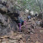 Click here for more information or to register Hosting Club: Toronto, Caledon Hills
Category: Car Hike
Location (Google Maps): Devil’s Pulpit – Meet at roadside parking, at intersection of Creditview Road and Grange Sideroad. N43.791491, W-79.975229. Map 14 Edition 31. Please arrive fifteen minutes early. Hike Leader(s): Ross Estrella Click here to contact Hike Leader(s) Pace: Brisk (4-5 km/hr), Moderate (3-4 km/hr)
Terrain: Hilly, Rocky, Variable
Distance: 12-13 kms Description
Hiking beauty is it’s simplicity. You set your destination and start the journey. The most natural way of refueling your body, mind and spirit while savoring the beauty of the landscape around you. You feel the breathe of fresh air and the earth under your feet. So join me and others explore Forks of the Credit – Devil’s Pulpit and nearby Side Trails. A comfortable, sturdy hiking shoe/boot and hiking poles are highly recommended to tackle the rocky section. Please bring sufficient liquid hydration snack and lunch. Bring sunscreen, bug repellent and sun head protection. Always carry your personal medication (if any) and health card at all time. Don’t forget the enthusiasm. Please arrive fifteen minutes early.
| 21 - Something Familiar and Something New
8:30 AM-12:00 PM 07/21/2025 https://hikes.brucetrail.org/event/something-familiar-and-something-new/2025-07-21/ Click here for more information or to register Hosting Club: Caledon Hills
Category: General
Location (Google Maps): Meet at Mono Community Centre Parking Lot, 754483 Mono Centre Road
Coordinates: 44.026195, -80.071516 Directions: From Highway 10, turn east on Dufferin Road 8/Mono Centre Road. Drive for approximately 6 kilometres. The community centre is on the right. Hike Leader(s): Sandy Green Click here to contact Hike Leader(s) Pace: Medium – 3 to 4 km/hour
Terrain: Moderate – some hills and/or some poor footing
Distance: 10 kilometres Description
Hike some familiar trails and a brand new trail, too. From Mono Centre, we’ll head south to loop through the Whitetail Refuge Nature Reserve, including the recently built Third Outlier Side Trail, and then head north for a final loop in the Mono Cliffs Provincial Park. Bring snacks and beverages to keep you energized. Sturdy footwear is highly recommended. All are welcome!
| 22 - Two Waterfalls Hike – Hogg’s Falls to Eugenia Falls return.
9:30 AM-2:00 AM 07/22/2025 https://hikes.brucetrail.org/event/two-waterfalls-hike-hoggs-falls-to-eugenia-falls-return/2025-07-22/  Click here for more information or to register Hosting Club: Caledon Hills
Category: Tuesday Hikers
Location (Google Maps): Beaver Valley; Hogg’s Falls Parking Area – km 65.1 on the west side of Lower Valley Rd. roughly 750 m north of East Back Line. Hike Leader(s): Doris Harper Click here to contact Hike Leader(s) Pace: Medium – 3 to 4 km/hour
Terrain: Moderate – some hills and/or some poor footing
Distance: approximately 12 km Description
From the parking lot on Lower Valley Rd. we will hike to Eugenia Falls which will include the Upper Beaver Valley Side Trail and the Eugenia Falls Side Trail. When we reach Eugenia Falls we will take a break, have lunch, explore the area and then return the way we came. If your plans change and you are no longer able to hike, please cancel so that we can make the space available for another interested hiker; and we don’t wait and wonder if something has happened to you. If things change and you need to cancel, please log-in to the BTC website, go to ‘my hikes’ and cancel. If you have any questions please contact the Hike Leader.
| 23 | 24 | 25 | 26  Sydenham Stained Glass Badge E2E Weekend Hikes Sydenham Stained Glass Badge E2E Weekend Hikes 8:00 AM-2:30 AM 07/26/2025 https://hikes.brucetrail.org/event/sydenham-stained-glass-badge-e2e-weekend-hikes/2025-07-26/ This is a Multi-Day HikeYou are signing up for the following dates:
2025-07-26, 2025-07-27, 2025-08-02, 2025-08-03, 2025-08-09, 2025-08-10, 2025-08-16, 2025-08-17 Click here for more information or to register Hosting Club: Caledon Hills, Sydenham
Category: End-to-End
Location (Google Maps): Parking lot off of 6th Concession Road 6 S. GPS location (44.509124, -80.810665) Hike Leader(s): Lily Li Click here to contact Hike Leader(s) Pace: Brisk – 4 to 5 km/hour, Medium – 3 to 4 km/hour
Terrain: Moderate – some hills and/or some poor footing, Strenuous – hilly with steep climbs and some poor footing
Distance: 21 km Description
Earn the Hart’s Tongue Stained Glass / Fundraiser badge, which is part of the collectible Bruce Trail Clubs stained glass-themed fundraiser set. This is a special series of 8 hikes in 4 weekends to complete the Sydenham section of 166 km. Hike distances range from 18 to 23 km each day with about a 3-5 km/hour pace. The hike is intended to be moderate to brisk. Please dress according to the weather presented that day. Bring at least 2 litres of water and electrolytes, lunch, snack, hat, sunscreen and bug spray for the long day of hiking. This is a car shuttle hike. Please have your vehicle ready, as everyone will take a turn either to drive to the start point of our hike or to get our drivers back to the start point at the end of the day. A detailed hiking plan will be shared with registered hikers later.
- Car Hike: Hockley Rd. to 4th Line EHS
8:30 AM-2:30 PM 07/26/2025 https://hikes.brucetrail.org/event/car-hike-hockley-rd-to-4th-line-ehs/2025-07-26/ Click here for more information or to register Hosting Club: Caledon Hills
Category: End-to-End
Location (Google Maps): Hockley Rd. parking area, east of km 61.1, located on the north side of Hockley Rd. at the Hockley Rd. Side Trail. Hike Leader(s): Dylan Hubbard Click here to contact Hike Leader(s) Pace: Brisk – 4 to 5 km/hour
Terrain: Strenuous – hilly with steep climbs and some poor footing
Distance: 13.5 km Description
Join me for a grueling summer hike as we hike from the main parking lot on Hockley Rd. to 4th Line EHS and back. This will complete a 14.5 km loop. Pace will be brisk, make sure to pack a lunch, sunscreen and bug repellent, at least 2L of water and good hiking boots. We will be taking our lunch at 11-11:30 depending on how the group feels. If the weather permits, I’ll be going to the Hockley Valley Resort for food afterwards. Please feel free to join me for truffle fries and mocktails 🙂
- Saturday Shorts at Meltwater Moraine Protected Natural Area
9:00 AM-11:30 AM 07/26/2025 https://hikes.brucetrail.org/event/saturday-shorts-at-meltwater-moraine-protected-natural-area/2025-07-26/  Click here for more information or to register Hosting Club: Caledon Hills
Category: General
Location (Google Maps): Meet at 17963 Mountainview Road. Park on the grass beside the driveway. Google Maps GPS Coordinates: 43.90027, -79.93036 Directions:
From Highway #10, turn east onto Olde Base Line Road/Peel Regional Road 12. Drive for approximately 7 kilometres. Turn north/left onto Mountainview Road. Drive for approximately 8 kilometres. The driveway is on the right. Don’t be surprised by the old house and farm buildings on the property. Hike Leader(s): Sandy Green Click here to contact Hike Leader(s) Pace: Leisurely – 3 km/hour or less
Terrain: Easy – mostly flat and usually good footing
Distance: 5 kilometres Description
Enjoy exploring the newest Bruce Trail Conservancy Protected Natural Area in the Caledon Hills section – Meltwater Moraine. Bring snacks and beverages to keep you energized. Sturdy footwear is highly recommended. All are welcome!
|
27 | 28 | 29 - City View Park, Burlington, Map 9.
9:30 AM-2:00 PM 07/29/2025 https://hikes.brucetrail.org/event/city-view-park-burlington-map-9-5/2025-07-29/ Click here for more information or to register Hosting Club: Caledon Hills
Category: Tuesday Hikers
Location (Google Maps): City View Park, Burlington.
From Highway 403 going west, turn right on Brant Street, left on Dundas Street, left on Kerns Rd., take second turn left into City View Park to the parking lot. Hike Leader(s): Mohammad Shafiq Click here to contact Hike Leader(s) Pace: Medium – 3 to 4 km/hour
Terrain: Moderate – some hills and/or some poor footing
Distance: 11 km Description
From City View Park will connect with main Bruce Trail and hike to Smokey Hollow waterfall, also hike Kings ST and Eric Best ST on the way. After snack break will trace back our steps and return to parking.
Bring water, snack for refreshment break at Smokey Hollow.
Dress for the weather, poles are recommended.
Optional refreshment stop after hike at a coffee or ice-cream place.
| 30 | 31 | August | August |