Join us for a hike! Registration required:
All hikes available to BTC members. Some hikes are open to non-members.
TIP: The calendar view displays up to 7 hikes on a day, but often there are more. Click “More events” to see them all.
Hosting Club: Caledon Hills
Category: End-to-End
Location (Google Maps): Meet at Dyer’s Bay parking, in the community parking area situated in the old quarry, just east of the trail at km 115.6. Shuttle to Crane Lake Rd. parking.
Hike Leader(s): Nancy Mooney Click here to contact Hike Leader(s)
Pace: Medium – 3 to 4 km/hour
Terrain: Easy – mostly flat and usually good footing, Moderate – some hills and/or some poor footing
Distance: Map 40 km 127.9 – km 115.6 12.3 km
Description
This is the fifth hike in the E2E series. There will be road walking to start and views over Dyer’s Bay.

Hosting Club: Caledon Hills
Category: Nature Walks
Location (Google Maps): Parking lot located off the 7th Line immediately east of Airport Road.
1.7 km north of Mono Mills (Highway 9)
Hike Leader(s): Gary Hall and Jim Chaput Click here to contact Hike Leader(s)
Pace: Leisurely – 3 km/hour or less
Terrain: Moderate – some hills and/or some poor footing
Distance: 4.5 kilometres
Description
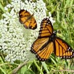
This “there and back” walk will begin by exploring the trail through the meadow of the Humber Heights property, then head through Mathilda’s Way, and the Gosling Forest and Nature Reserve to 5 Sideroad. We’ll then retrace our steps back to the 7th Line. We’ll stop regularly to listen to birds and watch for insects. There should be opportunities to see Bluebirds, Indigo Buntings, Monarch Butterflies, and many other wonders. Bring binoculars and your cellphone, as apps like Merlin, Seek, and iNaturalist can help in identification of flora and fauna along the route.
Hosting Club: Caledon Hills
Category: Tuesday Hikers
Location (Google Maps): Meet at Old York Rd. parking near Highway 6.
Driving direction: From Highway 403, go north on Highway 6, after about 1 km, take exit to Old York Rd., right on Old York Rd. (name changes to York Rd.), right on Old Guelph Rd. Keep on this road to reach parking near Highway 6 tunnel, close to Old Guelph Rd. Side Trail and the main Bruce Trail.
Hike Leader(s): Mohammad Shafiq Click here to contact Hike Leader(s)
Pace: Medium – 3 to 4 km/hour
Terrain: Moderate – some hills and/or some poor footing, Strenuous – hilly with steep climbs and some poor footing
Distance: 13 km
Description
Will go east through Highway 6 tunnel hiking main Bruce Trail through Clappison Woods and Grindstone Creek observing plants and birds on the way to Smokey Hollow Falls; take snack break there and trace back steps to the starting point, a “there and back” hike. Will observe silence, forest bathing, for 20 minutes during the hike.
Bring water, snack, hand sanitizer and bug spray.
Poles are recommended.
We are not out of COVID yet, so usual precautions are to be observed.
After hike, an optional lunch stop at Royal Coachman in Waterdown; will check and call the restaurant for reservation during hike.
Hosting Club: Caledon Hills
Category: End-to-End
Location (Google Maps): Meet at roadside parking at the south end of Carter Rd. km 98.5. Shuttle to Dyer’s Bay parking.
Hike Leader(s): Nancy Mooney Click here to contact Hike Leader(s)
Pace: Medium – 3 to 4 km/hour
Terrain: Moderate – some hills and/or some poor footing
Distance: Maps 40, 39 km 115.6 – km 98.5 Approx. 13 km (trail rerouted thanks to newly acquired Cape Chin property)
Description
This is the sixth hike of the E2E series. Sights to explore include Michigander’s Arch, Lillie Pothole Side Trail, Devil’s Monument. Lunch around km 100 at Cape Chin house.
Hosting Club: Caledon Hills
Category: Nature Walks
Location (Google Maps): BTC parking lot located off the 7th Line immediately east of Airport Road.
1.7 km north on Airport Road from Mono Mills (Highway 9)
Hike Leader(s): Gary Hall Click here to contact Hike Leader(s)
Pace: Leisurely – 3 km/hour or less
Terrain: Moderate – some hills and/or some poor footing
Distance: 4.5 kilometres
Description
This “there and back” walk will begin by exploring the trail through the meadow of the Humber Heights property, then head through Mathilda’s Way, and the Gosling Forest and Nature Reserve to 5 Sideroad. We’ll then retrace our steps back to the 7th Line. We’ll stop regularly to listen to birds and watch for insects. There should be opportunities to see Bluebirds, Indigo Buntings, Monarch Butterflies, and many other wonders. Bring binoculars and your cellphone, as apps like Merlin, Seek, and iNaturalist can help in identification of flora and fauna along the route.
Hosting Club: Caledon Hills
Category: Nature Walks
Location (Google Maps): Meet at Mono Community Centre on the east side of 2nd Line EHS, 200 metres south of Mono Centre. Park on the gravel surface lot.
From ON-10, head east on Side Road 20. At 2nd Line EHS turn left. Drive for 500 metres. The Community Centre is on the right.
Hike Leader(s): Gary Hall Click here to contact Hike Leader(s)
Pace: Leisurely – 3 km/hour or less
Terrain: Easy – mostly flat and usually good footing
Distance: 4.5 kilometres
Description
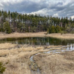
We’ll explore a part of the BTC’s latest land acquisition in the Caledon Hills Section, near Mono Centre. Forest, meadow and pond habitats on the property will be examined “through the eyes of a land steward.”
Hosting Club: Caledon Hills
Category: Tuesday Hikers
Location (Google Maps): Parking at: Side Road 10 and 4th Line Nassagaweya (trail entrance to Halton Regional Forest).
From Highway 401 West, turn right (north) on Guelph Line, right on Side Rd.10, it will bend northwards and become 4th Line Nassagaweya; park at the bend, roadside.
Hike Leader(s): Mohammad Shafiq Click here to contact Hike Leader(s)
Pace: Medium – 3 to 4 km/hour
Terrain: Moderate – some hills and/or some poor footing
Distance: 13 km
Description
Will hike trails in Halton Regional Forest, Hilton Falls Conservation Area and a beautiful part of the blue trail overlooking Beaver Dam. Trails are relatively flat with some rocky parts. Snack break at Hilton Falls.
Bring water, snack, hand sanitizer and face mask in your backpack.
Social distancing between hikers is preferred.
Dress according to weather.
Hike leader cell phone: 416-566-0503 (note that reception in hiking area is usually poor, leave messages to callback)
Hosting Club: Caledon Hills
Category: End-to-End
Location (Google Maps): Meet at Lion’s Head Harbour, south of km 83.0. Park on Phillip Forbes St. right on the Trail by the beach. Shuttle to Carter Rd. parking.
Hike Leader(s): Nancy Mooney Click here to contact Hike Leader(s)
Pace: Medium – 3 to 4 km/hour
Terrain: Easy – mostly flat and usually good footing, Moderate – some hills and/or some poor footing
Distance: Maps 39, 38 km 98.5 – km 83.0 15.5 km
Description
This is the seventh hike in the E2E series and we will be halfway! This hike includes Fred Binding Lookout, White Bluff, cliff caves, and 3 km of road walking along Isthmus Bay Rd. There will be poison ivy to watch out for.
Hosting Club: Caledon Hills
Category: Nature Walks
Location (Google Maps): Iroquoia Section, Map 10. Meet at Roadside Parking at km 95.8 on north shoulder of Britannia Rd., (at junction with Blind Line.)
Hike Leader(s): Janice McClelland Click here to contact Hike Leader(s)
Pace: Leisurely – 3 km/hour or less
Terrain: Moderate – some hills and/or some poor footing
Distance: 6.4 km
Description
We will walk the Bruce Trail and the River & Ruin Side Trail that pleasantly follows along Bronte Creek. In order to allow us to connect with nature during this Forest Bathing Walk, we will not talk during the walk – saving our cheerful conversation to before the walk, lunch break and after the walk. Please bring water and lunch for on the trail.
Hosting Club: Caledon Hills
Category: Tuesday Hikers
Location (Google Maps): Meet at 9:15 for a 9:30 departure at the NW parking lot to Island Lake Conservation Area.
Hike Leader(s): Peter Ostrowski Click here to contact Hike Leader(s)
Pace: Medium – 3 to 4 km/hour
Terrain: Easy – mostly flat and usually good footing
Distance: 9.7 km
Description
Meet at 9:15 for a 9:30 departure at the NW parking lot to Island Lake Conservation Area. The parking lot entrance is on the south side of Hockley Road 370 meters east of the stoplight on Highway 10 at Hockley Road a.k.a. County Road 16 and opposite Mono-Amaranth Public School. Parking is limited to about 20 cars so earlier or pooling is advised.
This is a very pleasant and beautiful circular walk along the boardwalks through marshes, forests and over islands. There are two washroom facilities on the route but no water.
Hosting Club: Caledon Hills
Category: End-to-End
Location (Google Maps): Meet at BTC Parking Area, km 67.9, off of Bruce Rd. 9 in Barrow Bay, just south of West Shore Rd. Shuttle to Lion’s Head Harbour.
Hike Leader(s): Nancy Mooney Click here to contact Hike Leader(s)
Pace: Medium – 3 to 4 km/hour
Terrain: Moderate – some hills and/or some poor footing
Distance: Map 38 km 83.0 – km 67.9 15.1 km
Description
This is the eighth hike in the series and includes Giant’s Cauldron Pothole Side Trail, Lion’s Head Pothole Side Trail, Isthmus Bay views, glacial erratics and more poison ivy! Ice cream and/or swimming opportunity in Lion’s Head!