Hosting Club: Niagara Category: Car Pool Location (Google Maps): Meet at SW shoulder of Willoughby & Escarpment Sideroad. Carpool to Boston Mills Rd west of Mississauga Rd.
Description This End-to-End series will start 2kms south of the Cheltenham Badlands and end at the Mono Centre. Earn your E2E Caledon Hills badge in 5 hikes ($10 for members). We will be carpooling and will ask for volunteers to drive other hikers. Please take turns with the driving.
Pace: Medium – 3 to 4 km/hr Terrain: Moderate – Some hills and/or some poor footing Distance: 9 kms
Description We will hike around the main trail, Oliver Creek Side Trail, Moss Haven Side Trail and across the road to the Rockhill Park Side Trail. Bring sufficient water and a snack, as needed.
There are some hills to contend with on this hike.
Pace: Medium (3.0 – 4.5 km/h): A comfortable pace for most hikers with steady progress. Terrain: Moderate: Rolling hills, mild slopes and rocky paths. Distance: 7 km
Description Jones Bluff Loop This is the first of a series of weekly men’s hikes held in conjunction with the Bruce Men’s Shed. We will meet at the Lion’s Head Royal Legion #202 on highway 6 at Hellyer Rd, Lion’s Head, just north of Ferndale.
Jones Bluff Trail offers wonderful escarpment views of both the rolling hills of Kings Point Bluff to the south and Sydney Bay to the north.
We will carpool to the Jones Bluff parking location and walk the main and side trails as a loop. The ground may be wet and slippery so hiking footwear is a must and hiking poles are suggested. Dress warmly in layers. Bring water and snack.
The hike should last about 2 hours with the possibility of lunch after.
Location (Google Maps): Parking lot is off Sycamore Drive East of Bayview , across Starbucks plaza Bus 91 from Finch east station stops at Sycamore station.
Pace: Moderate (3-4 km/hr) Terrain: Hilly, Level 2 (Intermediate – some hills and uneven surfaces, rocks and roots underfoot) Distance: 7-8 km
Description We will explore Valleyview and Maple View parks, and walk along German Mill Creak, in return we stop in Huntington park and have snack under beautiful shed.
Although this is considered an “Urban Walk”, you can expect some hills up and down and uneven surfaces with tree roots. Please bring hiking poles, water and snacks.
Hosting Club: Caledon Hills Category: Tuesday Hikers Location (Google Maps): Roadside parking on Mountainview Rd. Going north on Airport Road, turn left on Charleston Sideroad, left on Mountainview Road to the roadside parking. You may look for other directions depending upon where you are driving from.
Pace: Medium – 3 to 4 km/hour Terrain: Moderate – some hills and/or some poor footing Distance: 11-12 km
Description Will be hiking in and around Meltwater Moraine Nature Reserve, the main trail was relocated to this area eliminating road walk on Airport Road and Escarpment Road making the hike nature friendly. Will also explore all or parts of Metlwater, Songbird and Paris Moraine side trails. Open for a refreshment stop after hike, participants suggestions are welcomed.
Hosting Club: Dufferin Hi-Land Category: Tuesday Hike Location (Google Maps): Caledon Hills, Map 16: Meet at roadside parking at Km 26.0 on the north side of Escarpment Sideroad 0.6 km west of Mountainview Rd Note: The trails we will be hiking are not shown in the BT Guide, Edition 31. You can preview maps in the Trail Changes and Notices section of the BTC website or on the BTC app.
Pace: Leisurely Terrain: Moderate Distance: ~7 km; Short hike: 3-4 km
Description Remember slogging along Airport Rd with speeding cars and trucks blasting along beside you? Well, no more! The Main Trail has finally been moved off of the road and, as a bonus, two side trails have been added, creating new loop opportunities. Today we will shuttle to parking where the Main Trail crosses Airport Rd, then hike back taking in the Meltwater and Paris Moraine Side Trails. Bring water and snacks. Icers could be needed if winter comes early. Hiking poles recommended.
Hosting Club: Peninsula Category: Winter Hikes Location (Google Maps): Meet at Borchardt Parking lot. Hike South on the Main Trail to the boundary of 100 acre Cape Chin Woods.
Pace: Leisurely (2.0 – 3.0 km/h): A relaxed pace with frequent breaks and a focus on enjoyment. Terrain: Difficult: Steep ascents/descents, rocky scrambling, and some rugged escarpment paths. Distance: 4 km
Description Hike South on MT to boundary of Cape Chin Woods, Head in on unmarked Land Steward Trail, past an old deserted vehicle, vernal pools, dense cedar bush and towering hardwood forests. Some areas will be bush whacking so suggest wear water proof clothing. Land Steward, Tim Wilson, will discuss some of the duties of Land stewardship and what he is looking for on his perimeter walk. Expect hiking on ground that is lightly covered in snow.
Hosting Club: Iroquoia Category: Special Event Location (Google Maps): We will meet at V.A. Barrie Disc Golf Park at 68 Sunset Drive, St. Thomas on both days. Please arrive by 7:45 for check-in. Day 1 – We will start the hike in Port Stanley – parking in the Pierside Beach Parking Lot. Hiking is northbound. Day 2 – We will start our hike at the top end of the Elgin Trail 10002 Southdel St, Southwold. Look for the Elgin Trail/Thames Valley Trail signage. Hiking is southbound.
Pace: Brisk – 4 to 5 km/hr, Medium – 3 to 4 km/hr Terrain: Dependent on Conditions, Moderate – Some hills and/or some poor footing, Slippery and Steep Sections, Slippery Sections Likely, Strenuous – Hilly with steep climbs and some poor footing Distance: Approximately 22-25km per day
Description Occasionally hikes are offered outside of the Bruce Trail by Bruce Trail hike leaders in an effort to reach any members who reside outside of the immediate Bruce Trail area. This is a two day hike on the Elgin Hiking Trail which runs from Lake Erie in Port Stanley to 10002 Southdel St in Southwold, where it meets the Thames Valley Trail. Look for the Thames Valley/Elgin signage. Elgin Hiking Trail is approximately 42km long.
Please pack all the items you would require for a long day hike (food, snacks, 2l of water, first aid kit, extra socks) and dress in layers. Please bring rain gear if the forecast is for rain. This 2 day hike will be postponed if the forecast is such that we may have ice or snow. All registered hikers will be advised.
Please ensure you are capable of two long days of hiking at a brisk pace before signing up for these hikes. The trail is variable; some trail and quite a long stretch of road at the north end.
There is a club badge and an end to end badge available for purchase at $15each. Proceeds go toward supporting the Elgin Trail infrastructure and maintenance and also to show our support for the trail.
Please be prepared to share in the hiker shuttle by having at least 4 seatbelts available for use. This includes the driver. We may have a couple of Trail Angels from the club so fingers crossed, we won’t have to shuttle.
This hike is limited to 12 people.
Do you need accommodation? We have an Air B&B rental in St Thomas. The bedrooms are taken but we can bring a couple of air mattresses if you bring the linen. Please contact Ruth through this form if you are interested in sharing.
Please ensure you cancel your registration if your plans change. If someone else has registered you, please have them remove your registration. Cancelling your registration with lots of time to spare allows people who may be on a waitlist to participate.
Any questions may be directed through contact on this form. If you cannot make it, please remove yourself from registration by following these steps:
To cancel your registration, here is a step by step: – Sign into your account on the BTC website – Click on My Hikes under your account – This will take you to a list of hikes you have registered for – Scroll down to the appropriate hike and cursor over to the far right hand column under the Action column. – Click Cancel under the hike you wish to cancel
Hosting Club: Niagara Category: Car Pool Location (Google Maps): Meet in Short Hills Provincial Park, parking lot B, Roland Rd. Carpool to Glen Rd, Lincoln
Description This End-to-End series will start in Grimsby and end in Queenston. Upon completion of all 6 hikes, you can earn the new independent Brock monument badge. $10 for members and $15 for non-members. We will be carpooling and will ask for volunteers to drive other hikers. Please take turns with the driving.
Pace: Medium Terrain: Moderate, Some rocky footing, Some steep sections Length of Hike: 5 kms
Description We’ll follow the Main Trail from the parking lot and walk on the marsh boardwalks. The Trail then starts upland along an old cart trail along the scarp face. We’ll use the Bognar Marsh Side Trail to return towards the parking lot.
Guidelines
Arrive 15 minutes before the start of the hike.
Wear sturdy footwear and appropriate attire for the weather and the terrain. Hiking poles are a good idea in any season, especially if the terrain is rocky or slippery. In winter, snowshoes or icers/crampons are needed when conditions dictate. Wearing appropriate clothing and footwear prevents injuries and shows consideration for a safe and positive group hiking experience.
Always carry I.D. and your health card.
Bring sufficient water and snacks (or lunch if indicated). A minimum of 1L of water is recommended on all hikes, and 3L is recommended for long, challenging hikes in the heat of the summer.
Bring sunscreen and insect repellent (for spring and summer hikes).
Hosting Club: Sydenham Category: An evening walk. Location (Google Maps): Meet in the municipal parking lot by the river on the west side of 1st Ave E between 7th St E and 8th St E in Owen Sound
Pace: Medium: 3 to 4 km/h Terrain: Moderate: Some hills and/or poor footing, There might be icy and slippery sections. Distance: Approx 5 km
Description Join us for an evening Full Moon Hike visiting the Festival of Northern Lights displays in the River District and Harrison Park in Owen Sound. If there are icy conditions please bring icers to wear. There is no need to show up 15 minutes early for this hike, but we will leave promptly at 7:00 pm. Following the hike there is an opportunity to socialize over refreshments.
Location (Google Maps): Parking lot is off Sycamore Drive East of Bayview , across Starbucks plaza Bus 91 from Finch east station stops at Sycamore station.
Pace: Moderate (3-4 km/hr) Terrain: Hilly, Level 2 (Intermediate – some hills and uneven surfaces, rocks and roots underfoot) Distance: 7-8 km
Description We will explore Valleyview and Maple View parks, and walk along German Mill Creak, in return we stop in Huntington park and have snack under beautiful shed.
Although this is considered an “Urban Walk”, you can expect some hills up and down and uneven surfaces with tree roots. Please bring hiking poles, water and snacks.
Description This will be our permanent Thursday Location until Bridge repairs complete. Hike up from the Bailey bridge to Balls Falls and explore the trails
You must register for each hike. Bring Poles, snack and a drink. Dress for the weather
Hosting Club: Iroquoia Category: General Hike Location (Google Maps): Meet in the first parking lot at Crawford Lake at 9:15 am. Reserve your time at conservationhalton.ca
Pace: Medium – 3 to 4 km/hr Terrain: Moderate – Some hills and/or some poor footing Distance: 6-7 kms
Description Meeting at 9:15 am in the first parking lot, we will hike a loop around the hiking trails. This is a short hike but with a few rocky places. Parking reservations required.
Pace: Moderate (3-4 km/hr) Terrain: Level 2 (Intermediate – some hills and uneven surfaces, rocks and roots underfoot), Variable Distance: 9.1 k
Description Join us for a mid-week 9.1K hike from Terra Cotta Cotta Conservation area to Boston Mills. Our journey should take about 2 1/2 hours to complete. When we finish, there will be an opportunity to stop in at the Spirit Tree Estate for hot apple cider, baked goods or to purchase a Christmas basket for your family. If there is interest among the group , there is also a bistro where you may enjoy a full sit-down lunch.
We will start by shuttling some cars to the Tenth Line where we will park, then enter Terra Cotta Conservation area. This hike will take us through the park on the main Bruce Trail through mature forests, meadows and river valleys. The terrain will vary, there will be some hilly sections and sections with uneven, rocky terrain, making footing tricky to navigate. On arrival back at our cars, and after retrieving our shuttle vehicles, you will have an option to carry on to Spirit Tree Cidery, which is a 1 k drive away, with your hike leaders.
December weather can be unpredictable with cold winds, rain, sleet or snow! So, dress for the weather, keeping in mind to dress in layers and get your icers packed. Hiking shoes/boots are required and hiking poles are recommended. Bring plenty of fluids, including electrolytes, and a snack.
As this is a group hike, please consider your fitness level before registering. We will be walking at a pace of 3km – 4km per hour and everyone is expected to keep up with the person in front of them for the duration of the hike.
Plan to arrive at the meeting place by 9:45 a.m. as we will start the car shuffle to the hike starting point at 10 a.m. sharp. Further details will be provided to registered hikers a few days prior to the hike. Please indicate to the leaders if you wish to dine with us and we will work on reservations.
Hosting Club: Niagara Category: Night Location (Google Maps): Meet at Floral Showhouse, Niagara River Parkway, just south of the Falls. Parking Fee. Annual parking passes are the best rates.
Description Get into the holiday spirit with a walk among the Festival of Lights. Wear warmer clothes than you normally would for a hike so you can comfortably take photos.
Hot apple cider and treats will be shared following the hike. You are welcome to bring a treat to share.
Pace: Medium – 3 to 4 km/hr Terrain: Dependent on Conditions, Strenuous – Hilly with steep climbs and some poor footing Distance: 11.5 km
Description NOTE – THE DATE OF THIS HIKE HAS BEEN CHANGED FROM DECEMBER 1 TO DECEMBER 5
This is an end-to-end hiking series to complete the Caledon section of the Bruce Trail in 5 hikes.
The hikes will be undertaken at a medium pace of approximately 4 km/hour for approximately 15 kms each hike. Please consider your fitness level before registering; this is a group hike, and everyone is expected to keep pace with the person in front of them for the duration of the hike.
The weather can be changeable at this time of year, so dress in layers for any possibility. There here are many steep and hilly segments in this section of the Bruce Trail so the hikes will require considerable stamina. Wear hiking boots and bring hiking poles. Bring a snack, plenty of water and other hydration as needed.
We will be travelling from south to north over the course of the End-to-End. The series will require car shuffles, and everyone will be expected to participate as drivers.
Today’s hike, the fifth and final hike of the series, is 11.5 km in length. Please plan to arrive at the meeting place by 8:15 am as we will start the car shuffle at 8:30 am sharp.
Further details will be provided to registered hikers a few days prior to the hike.
Description Each Friday we will explore different neighbourhoods, trails and parkland throughout Historic Niagara-on-the-Lake.
Moderate pace with some weeks entirely on sidewalks and roads while others may include a mix of trails and paved pathways. Great way to build up endurance for longer more strenuous hikes.
Prepare for cooler windy conditions on open parkland and along Lake Ontario and Niagara River trails.
Plan to stay for conversation and a warm cup of coffee or tea at Sweets & Swirls, Community Centre, Niagara Stone Road, NOTL
Hosting Club: Dufferin Hi-Land Category: General Hike Location (Google Maps): Roadside parking on Prince of Wales Road at 20 Side Road. See Google Maps link for GPS.
Hike Leader(s): Stuart Law
Pace: Medium Terrain: Slippery and Steep Sections, Strenuous Distance: 11.5 kms
Description Join us on a snowy shuttle hike from 30 Side Road to 20 Side Road in the beautiful Dufferin Hi-Land section of the Bruce Trail. We will take in Black Bank and Honeywood. The hills will be steep and there will be a decent amount of snow. Icers mandatory. Snow shoes optional. Poles highly recommended. Please bring a warm drink, a snack and a smile. Please be ready to shuttle at 9:30 am sharp.
Hosting Club: Sydenham Category: General Hike Location (Google Maps): Indian Falls Conservation Area parking lot, 318614 Grey Rd 1 , in Balmy Beach, west side of the road. We will carpool from here.
Pace: Leisurely: 3 km/h or less Terrain: Moderate: Some hills and/or poor footing, Strenuous: Hilly with steep climbs and some poor footing., There might be icy and slippery sections., There might be muddy sections. Distance: 5.6 km
Description This is a delightful loop hike through the forest featuring wetlands, “wells”, erratics, fossils and views across the Glen.
Please bring water, snacks and poles if needed. If you are working towards the Sydenham geology badge, this would qualify for Beth’s “Savage Wells” hike. If you wish to purchase a copy of Beth Gilhespy’s geology book for Sydenham, please contact the leader directly prior to the hike. $37.oo cash or e-transfer at trail side. Carol Mullin 226-787-8804 call or text.
Pace: Leisurely (2.0 – 3.0 km/h): A relaxed pace with frequent breaks and a focus on enjoyment. Terrain: Easy: Flat forested sections or lowland trails. Distance: 3.5km
Description 🌕Full Moon Hike Series: Part 3 of 7 🌕 Serenade the Super-moon @ Black Creek Provincial Park
We’ll hike ~3.5 kms along a sandy trail through a softwood forest, then we’ll turn around to go back the way we came. Here we will enjoy the full moon on a sandy beach along the Lake Huron shoreline. For those interested, local song leader Beige McIntosh will guide the group in singing some simple nature songs to the stunning super-moon above (if you’re feeling shy you can just enjoy the sounds!). The moon offers us so much beauty, the least we can do is return the favour with a few songs! Please bring a blanket or chair to sit on at the beach and be aware there is poison ivy along the trail.
Badge Alert:
New this year – earn a Full Moon Hiking badge by joining 4 of the 7 hikes in this Full Moon Hiking Series.
What to bring:
Illuminate the path with a red light headlamp (or flashlight).
Sturdy boots
Appropriate clothing for the weather conditions (layers are great)
Pace: Brisk (4-5 km/hr), Moderate (3-4 km/hr) Terrain: Level 2 (Intermediate – some hills and uneven surfaces, rocks and roots underfoot), Rocky, Variable Distance: 8.7 km
Description Come celebrate with us the beginning of holiday season with a hike along the Niagara Escarpment with great views in Nottawasaga Bluffs Conservation Area. We will hike for about four hours at a 3.5 km/hr pace, explore the Key Hole Side Trail and enjoy the view from the Nottawasaga Bluffs Lookout. After the hike we will go to Mylar and Loreta’s Restaurant for our celebration luncheon. When you register, please select one of the lunch choices listed under optional items. All regular entrées include fries, dessert bar and non-alcoholic beverage. Vegetarian entrées include salad, dessert bar and non-alcoholic beverage. Tax and gratuity are included in the prices. Beer and wine are extra. You will need to pay your bus fare when you register. E-transfer your lunch money ($34 per person) to blennon@sympatico.ca.
Description Meet at Louth Conservation Area and Hike a Swayze Falls loop, taking some side trails along the way. Bring poles, icers, water and a snack.
Hosting Club: Toronto Category: Car Hike Location (Google Maps): Spirit Tree Estate Cidery West Parking Lot
Hike Leader(s): Alina Lin
Pace: Brisk (4-5 km/hr) Terrain: Challenging, Flat, Hilly, Level 2 (Intermediate – some hills and uneven surfaces, rocks and roots underfoot), Rocky, Variable Distance (km): 17 km
Description Since becoming a hike leader in 2015, I’ve had the joy of leading more than 200 group hikes—most memorably the End‑to‑End hikes of the Bruce Trail (900 km) for twice, Oak Ridges Trail (270 km), Ganaraska Trail (500 km), and the Grand Valley Trail (260 km). Along the way, I’ve met hundreds of enthusiastic hikers, been inspired by countless volunteers, and made lifelong friends. This is likely my last time leading an End-to-End hike on the Bruce Trail —a symbolic “Hanging Up the Boots” moment. But I’m not done hiking! New adventures await in Western Canada. Happy hiking, happy living!
Meeting Point : Spirit Tree Estate Cidery west parking lot ( west up of the main parking lot)- thanks their permission out of kindness! Please arrive at the parking area before 8:45am to allow time for car shuttle coordination.
We will car shuttle to Roadside parking east of KM33.4 across from the Eighth Line Side Trail on Eighth Line. GPS: 43.679840, -79.966419. From there we will hike main trail back to the KM 50 at the Creditview Rd.
All drivers are expected to participate in the car shuttle, either before or after the hike.
After hike option: Spirit Tree Cidery’s coffee, bakeries and pizza!
Important Notes:
Wear sturdy hiking footwear and dress appropriately for the weather. Icers might be needed.
Pace: Medium (3.0 – 4.5 km/h): A comfortable pace for most hikers with steady progress. Terrain: Moderate: Rolling hills, mild slopes and rocky paths. Distance: ~20km
Description Perched 80 feet above Georgian Bay, on the beautiful Bruce Peninsula, the Cabot Head Lighthouse has guided ships for over 100 years. Located in Cabot Head Nature Reserve on Georgian Bay. Today its closed to visitors, but we will have the unique opportunity to take in the views as we walk along the bay on the road to the lighthouse. From there we will take the trail to Wingfield Basin. A refuge for ships back in the day in stormy weather and today for sailors and boaters to anchor and rest. We will see relics from a ship left there many years ago. A reminder of the beauty and the strength of mother nature in this hidden gem. Let’s take a walk back in time.
This will be approximately a 20km out-and-back hike, and we aim to return to the parking lot by 3pm.
Please bring water, snacks, and lunch, as well as any refreshments you may need. Layered clothing is recommended since the weather may change throughout the day, and hiking poles are optional.
Our lunch stop will be at the Lighthouse before we head back to Harkins Rd parking.
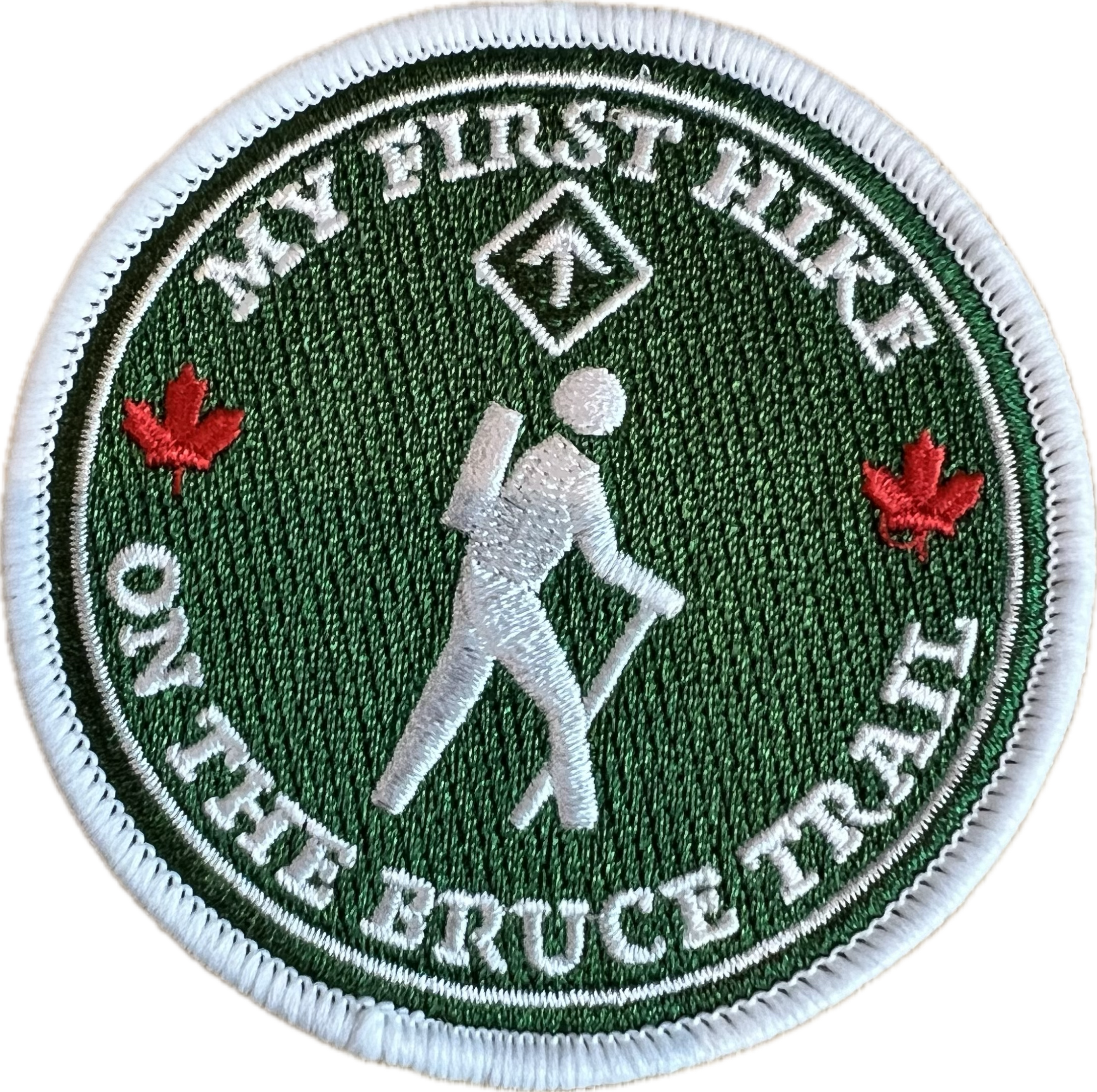
Hosting Club: Iroquoia Category: My First Hike Location (Google Maps): In the parking lot at Felker’s Falls Conservation Area. From Mud St turn north on Paramount Drive and continue to Ackland Street. Follow signage to parking area.
Pace: Leisurely – 3km/hr or less, Medium – 3 to 4 km/hr Terrain: Dependent on Conditions, Moderate – Some hills and/or some poor footing, Strenuous – Hilly with steep climbs and some poor footing Distance: 10km
Description Are you new to hiking? Do you need a little guidance on how to get started? This hike is for you! Please join experienced Hike Leader Ruth for a hike that will take us around Felker’s Falls and over to Devil’s Punchbowl Falls, if we’re feeling up for it. Please bring water, snacks and wear good sturdy hiking shoes/boots. Bring hiking poles if you use them. This introduction to hiking will be part instructional and part physical. Any and all questions about hiking and the Bruce Trail can be answered. Please dress for forecasted weather. All participants will receive a My First Hike badge and be entered in a draw for one, one year BTC membership to begin immediately and a 2 draws for a Bruce Trail Guide Ed 31.
Everyone is welcome, even if you are not new to hiking. Lots of hiking tips will be shared.
Pace: Leisurely: 3 km/h or less Terrain: Moderate: Some hills and/or poor footing, There might be icy and slippery sections., There might be muddy sections. Distance: Approx. 5.5 km
Description We will hike up the Wiarton side Trail into the Conservation Area. Depending on whether or not there is snow, we will snowshoe into the Corran area and hike spirit Rock side trail and through the meadow area heading towards Colpoy’s Bay to the road and then return via Wiarton Side trail. If there is no snow or light conditions, we will consider doing the same route but return via the spiral staircase and along the main trail back to our cars. This hike will be rife with flexibility depending on our winter conditions. An opportunity to maybe have coffee or lunch afterwards can be considered.
Hosting Club: Caledon Hills Category: General Location (Google Maps): Meet at the Mono 5 Sideroad parking area at km 45.4 on the north side of the road where the Trail crosses. This is east of Airport Road. It is best to aim for arriving around 9:45, so we can start hiking as close to 10 am as possible. Thanks!
Pace: Medium – 3 to 4 km/hour Terrain: Moderate – some hills and/or some poor footing Distance: Approximately 5 km
Description Looking to get out on a Saturday but not give up your whole day? Saturday Shorts, a hiking series, will get you out in a small group on a short hike. Following the main Bruce Trail and side trails, this Saturday’s hike takes us through Hockleycrest. We will cover our approximately 5 km route at a comfortable pace, which allows for enjoying our time out in nature. Things to consider in your preparations: hiking shoes/boots, icers (depending on trail conditions), poles, warm gear, dressing in layers, water, and a snack. There will be short standing breaks. No dogs please.
After the hike, you may wish to visit the CHBTC’s winter market just around the corner at Hockleycrest on Airport Road. Proceeds from all sales support the BTC.
Pace: Brisk (4-5 km/hr), Moderate (3-4 km/hr) Terrain: Level 2 (Intermediate – some hills and uneven surfaces, rocks and roots underfoot), Rocky, Variable Distance: 8.7 km
Description Come celebrate with us the beginning of holiday season with a hike along the Niagara Escarpment with great views in Nottawasaga Bluffs Conservation Area. We will hike for about four hours at a 3.5 km/hr pace, explore the Key Hole Side Trail and enjoy the view from the Nottawasaga Bluffs Lookout. After the hike we will go to Mylar and Loreta’s Restaurant for our celebration luncheon. When you register, please select one of the lunch choices listed under optional items. All regular entrées include fries, dessert bar and non-alcoholic beverage. Vegetarian entrées include salad, dessert bar and non-alcoholic beverage. Tax and gratuity are included in the prices. Beer and wine are extra. You will need to pay your bus fare when you register. E-transfer your lunch money ($34 per person) to blennon@sympatico.ca.
Description Meet at Louth Conservation Area and Hike a Swayze Falls loop, taking some side trails along the way. Bring poles, icers, water and a snack.
Hosting Club: Toronto Category: Car Hike Location (Google Maps): Spirit Tree Estate Cidery West Parking Lot
Hike Leader(s): Alina Lin
Pace: Brisk (4-5 km/hr) Terrain: Challenging, Flat, Hilly, Level 2 (Intermediate – some hills and uneven surfaces, rocks and roots underfoot), Rocky, Variable Distance (km): 17 km
Description Since becoming a hike leader in 2015, I’ve had the joy of leading more than 200 group hikes—most memorably the End‑to‑End hikes of the Bruce Trail (900 km) for twice, Oak Ridges Trail (270 km), Ganaraska Trail (500 km), and the Grand Valley Trail (260 km). Along the way, I’ve met hundreds of enthusiastic hikers, been inspired by countless volunteers, and made lifelong friends. This is likely my last time leading an End-to-End hike on the Bruce Trail —a symbolic “Hanging Up the Boots” moment. But I’m not done hiking! New adventures await in Western Canada. Happy hiking, happy living!
Meeting Point : Spirit Tree Estate Cidery west parking lot ( west up of the main parking lot)- thanks their permission out of kindness! Please arrive at the parking area before 8:45am to allow time for car shuttle coordination.
We will car shuttle to Roadside parking east of KM33.4 across from the Eighth Line Side Trail on Eighth Line. GPS: 43.679840, -79.966419. From there we will hike main trail back to the KM 50 at the Creditview Rd.
All drivers are expected to participate in the car shuttle, either before or after the hike.
After hike option: Spirit Tree Cidery’s coffee, bakeries and pizza!
Important Notes:
Wear sturdy hiking footwear and dress appropriately for the weather. Icers might be needed.
Pace: Medium (3.0 – 4.5 km/h): A comfortable pace for most hikers with steady progress. Terrain: Moderate: Rolling hills, mild slopes and rocky paths. Distance: ~20km
Description Perched 80 feet above Georgian Bay, on the beautiful Bruce Peninsula, the Cabot Head Lighthouse has guided ships for over 100 years. Located in Cabot Head Nature Reserve on Georgian Bay. Today its closed to visitors, but we will have the unique opportunity to take in the views as we walk along the bay on the road to the lighthouse. From there we will take the trail to Wingfield Basin. A refuge for ships back in the day in stormy weather and today for sailors and boaters to anchor and rest. We will see relics from a ship left there many years ago. A reminder of the beauty and the strength of mother nature in this hidden gem. Let’s take a walk back in time.
This will be approximately a 20km out-and-back hike, and we aim to return to the parking lot by 3pm.
Please bring water, snacks, and lunch, as well as any refreshments you may need. Layered clothing is recommended since the weather may change throughout the day, and hiking poles are optional.
Our lunch stop will be at the Lighthouse before we head back to Harkins Rd parking.
Hosting Club: Iroquoia Category: My First Hike Location (Google Maps): In the parking lot at Felker’s Falls Conservation Area. From Mud St turn north on Paramount Drive and continue to Ackland Street. Follow signage to parking area.
Pace: Leisurely – 3km/hr or less, Medium – 3 to 4 km/hr Terrain: Dependent on Conditions, Moderate – Some hills and/or some poor footing, Strenuous – Hilly with steep climbs and some poor footing Distance: 10km
Description Are you new to hiking? Do you need a little guidance on how to get started? This hike is for you! Please join experienced Hike Leader Ruth for a hike that will take us around Felker’s Falls and over to Devil’s Punchbowl Falls, if we’re feeling up for it. Please bring water, snacks and wear good sturdy hiking shoes/boots. Bring hiking poles if you use them. This introduction to hiking will be part instructional and part physical. Any and all questions about hiking and the Bruce Trail can be answered. Please dress for forecasted weather. All participants will receive a My First Hike badge and be entered in a draw for one, one year BTC membership to begin immediately and a 2 draws for a Bruce Trail Guide Ed 31.
Everyone is welcome, even if you are not new to hiking. Lots of hiking tips will be shared.
Pace: Leisurely: 3 km/h or less Terrain: Moderate: Some hills and/or poor footing, There might be icy and slippery sections., There might be muddy sections. Distance: Approx. 5.5 km
Description We will hike up the Wiarton side Trail into the Conservation Area. Depending on whether or not there is snow, we will snowshoe into the Corran area and hike spirit Rock side trail and through the meadow area heading towards Colpoy’s Bay to the road and then return via Wiarton Side trail. If there is no snow or light conditions, we will consider doing the same route but return via the spiral staircase and along the main trail back to our cars. This hike will be rife with flexibility depending on our winter conditions. An opportunity to maybe have coffee or lunch afterwards can be considered.
Hosting Club: Caledon Hills Category: General Location (Google Maps): Meet at the Mono 5 Sideroad parking area at km 45.4 on the north side of the road where the Trail crosses. This is east of Airport Road. It is best to aim for arriving around 9:45, so we can start hiking as close to 10 am as possible. Thanks!
Pace: Medium – 3 to 4 km/hour Terrain: Moderate – some hills and/or some poor footing Distance: Approximately 5 km
Description Looking to get out on a Saturday but not give up your whole day? Saturday Shorts, a hiking series, will get you out in a small group on a short hike. Following the main Bruce Trail and side trails, this Saturday’s hike takes us through Hockleycrest. We will cover our approximately 5 km route at a comfortable pace, which allows for enjoying our time out in nature. Things to consider in your preparations: hiking shoes/boots, icers (depending on trail conditions), poles, warm gear, dressing in layers, water, and a snack. There will be short standing breaks. No dogs please.
After the hike, you may wish to visit the CHBTC’s winter market just around the corner at Hockleycrest on Airport Road. Proceeds from all sales support the BTC.
Pace: Medium – 3 to 4 km/hr Terrain: Easy – Mostly flat and usually good footing, Moderate – Some hills and/or some poor footing, Strenuous – Hilly with steep climbs and some poor footing Distance: 6.5km
Description A hike and a viewing of the Fantasy of Trees – what could be better to get us all into the holiday spirit?! We will meet at the Lion’s Club Pool parking lot in Grimsby at 1 Elm St. Our hike will take us up to Beamer’s Memorial Conservation Area where we will hike and admire all the wonderful views this area has to offer. Then we will hike over to view the waterfalls and then double back and hike back down the hill where we will change our shoes if they are muddy. If the trails aren’t muddy, we will proceed to the Grimsby Museum and admire all the wonderful trees that have been decorated by volunteers and sponsored by local businesses and individuals. Want a chance to win a one-year Bruce Trail Membership (must be redeemed by end of 2025) and prize pack? There’s one on the raffle table donated by Ruth, your hike leader.
This is a free event but if you’d like to buy tickets, they are available on site. This is the last day of the event which is held every year by Grimsby Rotary. All proceeds go back to charitable organizations in the community.
The hill climb is considered strenuous but the rest of the hike is moderate. Please bring enough water and snacks and icers, just in case.
Pace: Medium – 3 to 4 km/hr Terrain: Moderate – Some hills and/or some poor footing Distance: 10 kms
Description Meet in the parking lot off 8 Line at 9:15 am. We’ll hike the Maureen Smith Side Trail to the main trail and around the Great Esker Side Trail, back to the main trail and the Bennet Heritage Side Trail for a total of about 10 kms. There are some hills. Bring water and a snack.
Hosting Club: Toronto Category: Urban Walk Location (Google Maps): Rowntree Mills Station on Finch West LRT Line (at Islington Avenue and Finch). This is opening weekend so crowds are likely. You can also take the Islington Bus from Islington Station. Allow extra time at Finch West Station if you plan to take the LRT.
Pace: Moderate (3-4 km/hr) Terrain: Level 1 (Easy – mostly on flat, well maintained trails with hard-packed surface), Variable Distance: 10 km
Description Join us for a ride on the newly opened Finch West LRT to Rowntree Mills Station (Islington Avenue) from where we will hike south on the Humber River to Lawrence Avenue and Weston Road. From there you can walk to the Weston GO Station which will now have 30 minute service to Bloor Station and Union Station to connect with the TTC so you will have a complete transit experience – ride to Bloor to connect with TTC’s Line 2 Subway for just $0.30 more with a Presto Card. Our hike will take us on scenic parts of the Humber River Recreational Trai,l with a break for a short stretch on Weston Road, on mostly flat and paved surfaces.
Pace: Leisurely: 3 km/h or less Terrain: Moderate: Some hills and/or poor footing, Strenuous: Hilly with steep climbs and some poor footing., There are crevices or holes which may be hidden by layers of snow. Hike with extreme caution., There might be icy and slippery sections. Distance: 2.1 km
Description We will carpool to do a loop hike of the Mystery Cabin side trail. This is hike 37 in the book Exploring Sydenham. There will be one secret to find. If you do not have a book and would like one ($30) let me know by using the “Contact hike leader” link.
Hosting Club: Niagara Category: Night Location (Google Maps): Park at the Floral Showhouse, Niagara River Parkway, just south of the Falls. Parking fee. Annual parking pass is the best option.
Description Get into the holiday spirit with a walk around the Festival of Lights. Wear warmer clothes than you normally would for a hike so you can stop and enjoy the sights.
Hot apple cider and treats will be available following the hike. You are welcome to bring a treat to share.
Hosting Club: Niagara Category: Car Pool Location (Google Maps): Meet at Innis Lake Rd north of Finnerty Sideroad. Carpool to SW shoulder of Willoughby & Escarpment Sideroad.
Description This End-to-End series will start 2kms south of the Cheltenham Badlands and end at the Mono Centre. Earn your E2E Caledon Hills badge in 5 hikes ($10 for members). We will be carpooling and will ask for volunteers to drive other hikers. Please take turns with the driving.
Pace: Medium: 3 to 4 km/h Terrain: Moderate: Some hills and/or poor footing Distance: 8 km
Description Description – Figure 8. First loop Main Trail and Whicher Side Trail. Second loop starts by crossing over County Rd 9 on the Main Trail (now heading towards Wiarton)Continue to the Bull Homestead barn foundation (at the top of Colpoy’s Hill). Return on road or retracing our steps on the Main Trail.
Dress warmly in layers with good footwear. Hiking poles may be helpful. Bring water and snacks. Arrive 15 min before hike start time. Be prepared for mud, wet conditions, or snow!
Pace: Brisk – 4 to 5 km/hour Terrain: Strenuous – hilly with steep climbs and some poor footing Distance: 22.8 km
Description This hike series covers the Niagara section; 83 km over 4 days.
We will meet each morning at 7:45 and be ready to shuttle at 8:00. Hikers will take turns shuttling and taking drivers to their cars each day. Any parking costs will be shared among hikers.
Hikers should wear layered clothing, hiking boots, poles, hat, sunscreen, bug spray, rain gear and bring plenty of water, snacks and lunch. We will hike rain or shine.
Full itinerary will be emailed to hikers the week before the first hike.
Location (Google Maps): Parking lot is off Sycamore Drive East of Bayview , across Starbucks plaza Bus 91 from Finch east station stops at Sycamore station.
Pace: Moderate (3-4 km/hr) Terrain: Hilly, Level 2 (Intermediate – some hills and uneven surfaces, rocks and roots underfoot) Distance: 7-8 km
Description We will explore Valleyview and Maple View parks, and walk along German Mill Creak, in return we stop in Huntington park and have snack under beautiful shed.
Although this is considered an “Urban Walk”, you can expect some hills up and down and uneven surfaces with tree roots. Please bring hiking poles, water and snacks.
Pace: Leisurely Terrain: Moderate, Slippery and Steep Sections Distance: 5.6 Km, Short hike: 2.5 Km.
Description We will hike a loop consisting of Hockley Rd and Tom East Side Trails and Main Trail. Shorter hike will turn back where the Tom East trail turns sharply to the east. Bring water and snacks. Icers may be required. Hiking poles are recommended.
Hosting Club: Caledon Hills Category: Tuesday Hikers Location (Google Maps): 1695 Dundas Street W., Mississauga. Driving direction: From Highway 403, go south on Erin Mills Parkway, turn left on Dundas Street, after passing Mississauga Rd. and bridge, Erindale Park entrance is on left. Be careful of the two way traffic at the entrance, it may be convenient to drive past and take u-turn at next traffic lights. After entrance, drive about 300 meters to first parking lot on right, near washrooms.
Pace: Medium – 3 to 4 km/hour Terrain: Moderate – some hills and/or some poor footing Distance: 10 km
Description Will hike along Credit River between Erindale Park and Riverwood Conservancy, there and back. After hike there is optional lunch stop at a nearby restaurant. You may join hike only at your convenience.
Hosting Club: Niagara Category: Car Pool Location (Google Maps): Meet at DeCew House, DeCew Rd, Thorold. Carpool to Short Hills Provincial Park, Parking Lot B, Roland Rd.
Description This End-to-End series will start in Grimsby and end in Queenston. Upon completion of all 6 hikes, you can earn the new independent Brock monument badge. $10 for members and $15 for non-members. We will be carpooling and will ask for volunteers to drive other hikers. Please take turns with the driving.
Hosting Club: Caledon Hills Category: General Location (Google Maps): Southwest shoulder of Willoughby Rd. and Escarpment Sideroad. From ON-10 head west on Escarpment Sideroad until you meet Willoughby Road. Also possible to take Willoughby Road south from 124 just west of Highway 10.
Pace: Medium – 3 to 4 km/hour Terrain: Strenuous – hilly with steep climbs and some poor footing Distance: 9 km
Description This is the first hike in some new bi-monthly hikes – the Humpday Hikers. The hikes will be from 8 – 11 km in length with a short snack break. Option to join the group post hike at a local spot for refreshments and some comraderie.
This hike loops through the Forks of the Credit Provincial Park with a stop at the Credit River. This hike has some big hills and can be strenuous.
Bring your choice of hydration and snack. Hiking boots, poles and carry your icers/crampons as it is possible to have snow this time of year.
If you can plan to come for a warm drink and treat at Coy Wolf Coffee in Inglewood after the hike.
Participants will be notified the night before if a hike must be cancelled due to inclement weather.
Pace: Medium Terrain: Moderate, Some rocky footing, Some steep sections Length of Hike: 5 km
Description This hike through Silent Valley is special. Cedar groves, scarp face and large boulders as well as the site of an old farm. Interesting historical features including the remains of a downed airplane. Please bring a drink and, if you’d like, a snack.
Guidelines
Arrive 15 minutes before the start of the hike.
Wear sturdy footwear and appropriate attire for the weather and the terrain. Hiking poles are a good idea in any season, especially if the terrain is rocky or slippery. In winter, snowshoes or icers/crampons are needed when conditions dictate. Wearing appropriate clothing and footwear prevents injuries and shows consideration for a safe and positive group hiking experience.
Always carry I.D. and your health card.
Bring sufficient water and snacks (or lunch if indicated). A minimum of 1L of water is recommended on all hikes, and 3L is recommended for long, challenging hikes in the heat of the summer.
Bring sunscreen and insect repellent (for spring and summer hikes).
Hosting Club: Iroquoia Category: General Hike Location (Google Maps): Meet at the corner of 10 SR and 4th Line, off Guelph Line, north of Campbelville.
Hosting Club: Iroquoia Category: Special Event Location (Google Maps): We are meeting at Hidden Valley Park 1137 Hidden Valley Rd, Burlington, ON L7P Please arrive and be ready to go by 7pm. We will car shuttle over to the RBG in my vehicle and return to Hidden Valley around 9pm.
Pace: Leisurely – 3km/hr or less Terrain: Easy – Mostly flat and usually good footing Distance: Less than 2km
Description We have a limited number of free tickets for this event. Please register only if you know you can attend.
❄️ Dress for the weather – wear a festive hat, if you like.
💲Free
Other details are below.
Experience the magic of the season at Royal Botanical Gardens’ Winter Wonders! Hendrie Park transforms into a winter wonderland, featuring dazzling lights, festive art installations, and enchanting displays. Stroll the scenic pathways to the soundtrack of festive music.
Expect to spend approximately 1-2 hours at this experience.
Please leave your pets at home for this experience, pets are not permitted (service dogs excluded).
Outside food and beverage will not be permitted.
Please be aware that some areas of the garden contain fast moving, bright lights
Location (Google Maps): Parking lot is off Sycamore Drive East of Bayview , across Starbucks plaza Bus 91 from Finch east station stops at Sycamore station.
Pace: Moderate (3-4 km/hr) Terrain: Hilly, Level 2 (Intermediate – some hills and uneven surfaces, rocks and roots underfoot) Distance: 7-8 km
Description We will explore Valleyview and Maple View parks, and walk along German Mill Creak, in return we stop in Huntington park and have snack under beautiful shed.
Although this is considered an “Urban Walk”, you can expect some hills up and down and uneven surfaces with tree roots. Please bring hiking poles, water and snacks.
Description This will be our permanent Thursday Location until Bridge repairs complete. Hike up from the Bailey bridge to Balls Falls and explore the trails
You must register for each hike. Bring Poles, snack and a drink. Dress for the weather
Hosting Club: Sydenham Category: General Hike Location (Google Maps): Roadside parking at the bend in the St. Vincent-Sydenham Townline, 5 km north of Highway 26. This location is found at km 52.7 on Map 30 of Edition 31 of the Bruce Trail Reference. For directions using GPS Coordinates, open a map on your device by following the link embedded in “Google Maps” at the start of this description or copy them from here: 44.63754, -80.73343
Pace: Brisk: 4 to 5 km/h Terrain: Moderate: Some hills and/or poor footing Distance: 13 km
Description The hike title says it all! A Friday morning hike at brisk pace for 3-4 hours on the Bruce Trail, even if the weather is, um, brisk. Brisk Fridays are right for you if you are looking for a faster hiking experience which energizes and enlivens. On this hike, we will traverse the inviting trails in the Bayview Escarpment Nature Reserve along the main Bruce Trail and the River Kwai Side Trail, looping back to our vehicles. Arrive 15 min early, dress in layers with good footwear. Poles may be helpful. Bring water and a snack. See you there!
Hosting Club: Niagara Category: Urban Location (Google Maps): Park on King St near Centre St at entrance to Veteran’s Memorial Park, Niagara-on-the-Lake
Description Each Friday we will explore some history of Niagara-on-the-Lake while getting a moderate paced walk. Discover where the Niagara River meets Lake Ontario. Experience the Heritage District, woods and the Niagara Parkway.
Some weeks may be totally on sidewalks and roads while others may include a mix of trail and paved pathways.
Great way to build up endurance for longer more strenuous hikes.
Following the hike this week we are invited to Sharon & Graham Summerhayes’ home to celebrate the holidays together! Sharon & Graham provide holiday cheer and some tasty treats. You are welcome to bring along something to share. Address will be provided to hike registrants.
Hosting Club: Dufferin Hi-Land Category: General Hike Location (Google Maps): End of Boston Mills Road to the immediate west of Mississauga Road. Between kms 47.4 and 48.3 on BTC Map 14. 43.75061558050969. -79.9517816135864
Pace: Medium Terrain: Slippery Sections Likely, Moderate Distance: 16.5 kms
Description Join us for a lovely early winter loop hike through the Terra Cotta Conservation Area. Terrain is rocky in spots and it will be icy and snowy as well for sure. Icers, hiking boots and gaiters essential. Poles recommended. Please bring a smile, water, a snack, warm drink and a lunch. Please be ready to hike at 9:15 am.
Pace: Medium – 3 to 4 km/hr Terrain: Moderate – Some hills and/or some poor footing Distance: 8 kms
Description Meeting at 9:15 am in the parking lot, we will hike to the Falls and then around to Bent Rim 1 and back to the cars. Reserve your time at conservationhalton.ca
Pace: Medium – 3 to 4 km/hr Terrain: Moderate – Some hills and/or some poor footing Distance: 8.5km
Description Whether you are Camino-curious, have hiked a Camino or just want to hike, please join us. It will be a great opportunity to share information about hiking a Camino or recommend books, films, outfitters, etc. Everyone is welcome.
Please bring enough water, snacks and sturdy boots and icers if winter conditions are present. We will hike about 8.5km return, Medium pace and Moderate Terrain.
Pace: Medium – 3 to 4 km/hr Terrain: Moderate – Some hills and/or some poor footing Distance: 13 -14 km
Description This queer-led, all-inclusive 2SLGBTQIA+ hike starts in downtown Ancaster, connects with the Bruce Trail—stopping at three waterfalls—then follows a mishmash of sidetrails with lunch at the Trail Centre/Historic Train Station (indoor washroom facilities, warming station). Arrive by 9:15 a.m. for a 9:30 a.m. start.
Fully accessible by Hamilton Public Transit or car. We’ll start and end in the same spot, no shuttle or carpooling required.
What’s a Rainbow Hike: The aim of the Bruce Trail’s Rainbow Hikes is to create a safe, welcoming space for 2SGBTQIA+ hikers—including trans, gay, lesbian, bisexual, queer, Two-Spirit, intersex, asexual, and straight friends—to show up and be themselves in a safe and friendly outdoor setting. Our hiking group typically includes 20 to 25 people representing a full spectrum of sexual orientations, gender identities, and expressions. Diversity Rules 🙂
Highlights for this hike: three waterfalls (Tiffany, Sherman and Canterbury), Hermitage ruins, Dundas Valley Conservation nature interpretation centre, replica Victorian-style train station, two train cabooses from the 1920s—with an optional post-hike visit to the gay-owned and operated Trails Cafe in downtown Ancaster. Where to meet: We’ll rendezvous at the small parking lot right the corner of Wilson Street East and Academy in Ancaster (put 392 Wilson Street East into your GPS).
Coming by Hamilton Transit: Take the 5A MEADOWLANDS via McMASTER bus from King and Bay, get off at Rousseaux at Wilson (in Ancaster), and walk 5 minutes (max) up Wilson street to our meeting spot.
Parking at corner oof Wilson Street East and Academy. Just look for the unpaved parking lot right at the corner. Free. If full, there’s also parking across the street.
If you arrive early and you need to visit the loo or wait in a warm place, there’s a Tim Horton’s (370 Wilson). You need to ask for the washroom key and they may prioritize people who are buying something. Try your luck!
Bring sufficient water and proper lunch. Hiking boots are recommended, icers too. Dress in layers. Gaiters, to protect pants from mud, are a good idea.
Get your complimentary Bruce Trail Rainbow badge!
Feel free to reach out to the Hike Leader Doug if you have any questions at all- “Click here to contact Hike Leader” on this form.
Description Join the Niagara Bruce Trail Club, Bridges Niagara Immigrant and Refugee Services and PFLAG Niagara for a Rainbow-Welcome Hike at Louth Conservation Area!
Enjoy the sights and sounds of this beautiful conservation area, which has two waterfalls!
What is a Rainbow-Welcome Hike?
These hikes aim to bring 2S-LGBTQIA+ newcomers together with other newcomers and community members, friends and allies to enjoy nature and connect to the land.
It is an affirming space for people of diverse backgrounds and identities. Everyone is welcome. We will have Bruce Trail PRIDE stickers for all hikers, and a limited number of PRIDE badges if you don’t yet have one!
Hike Details
Route: This hike loops around Louth Conservation area side trails and the Bruce Trail for about 5 km, visiting both the main waterfall and the lower falls.
Terrain: The terrain has some ups and downs along the escarpment edge and into and out of the valley. At this time of year, it can be muddy, icy or both. We will adjust the pace to the group but be prepared for some rocky, uneven footing and clambering up and down. We recommend using hiking poles and wearing good hiking shoes is a must. If the weather conditions are snowy or icy, icers/microspikes may be needed. Carry water and dress for changeable weather.
Map: https://maps.app.goo.gl/LWWRPcRWMHEJwNbi8
Note: There are no toilets on this route.
***Please arrive by 9:50 to check in with the hike leader for departure at 10.
There is a small parking lot at the entrance to the conservation area and additional parking along Sue Ann Staff Avenue. We will meet at 9:50 at the parking lot to check in before heading out at 10.
Hosting Club: Caledon Hills Category: Introductory Location (Google Maps): Meet at Bruce Trail Parking Lot at Riverside Woods Nature Reserve 713377 1st Line EHS, Mono Google GPS Coordinates: 43.959916, -80.070494
Directions: From Hwy #10 north of Orangeville turn east on Hockley Road. Drive for 1.1 km. Continue straight onto Side Road 5 for 1.6 km. Turn left onto 1st Line EHS for 900 metres. Continue straight into the parking lot.
FYI There is an outhouse at the parking lot.
***DO NOT take 1st Line EHS south from Hockley Road. It is NOT maintained. Google Maps may suggest this impassable route.
Pace: Leisurely – 3 km/hour or less Terrain: Moderate – some hills and/or some poor footing Distance: 5 km
Description Looking to get out on a Saturday without giving up your whole day? This Saturday Short hike will get you out in a small group on a short forest adventure. Dress for chilly temperatures, and depending on the snow and ice conditions, pack icers/crampons. Bring a beverage and snack to keep you fuelled during the hike. The hike promises to be a fun one. Everyone is welcome!
After the hike, you may wish to visit the CHBTC’s Winter Market, Hockleycrest Farm 933445 on the east side of Airport Road, Mono.
Pace: Moderate (3-4 km/hr) Terrain: Challenging, Hilly, Level 2 (Intermediate – some hills and uneven surfaces, rocks and roots underfoot), Variable Distance (km): 10.17 km
Description Please join me for a holiday hike in the Rouge National Urban Park, which has been voted by some members as my best and exhilarating one. On this hike, you can expect rolling hills, and stunning vistas, including the largest remaining wetland in the City of Toronto.
The hike starts at the Toronto Zoo entrance. To get there, you can meet me at Kennedy TTC station by 9:55 am for a 42-minute bus ride, or you can take the 85 Sheppard East bus route from Don Mills Station or Rouge Hill GO station. If driving, consider parking for free next to the Rouge Valley Conservation Centre (Pearse House), GPS (43.81780727235202, -79.17176449225887), where the hike ends, and walk over to the Toronto Zoo entrance. This walk is about 10 minutes.
Please bring at least 2 liters of water, a snack and dress for the cold. Hiking poles are recommended. Bring icers just in case. Expect some hilly terrain.
Apres-hike at The Stone Cottage Pub, to share the holiday season with fellow hikers. Please wear Holiday colors and bring your appetite.
Here is an online map of our route (https://onthegomap.com/s/9mpj477d) Rouge Park Map
Update: The Park Rd entrance to Rouge National Urban Park is closed for construction of the new visitor centre. This includes a portion of Vista Trail from the platform area to the road therefore Orchard Trail and Vista Trail do not connect at this time. Parking at the Rouge Valley Conservation Area is very small and reserved for RVCC visitors, not park users. Parking is available at 55 Twyn Rivers Drive or at 7450 Kingston Rd. Here’s a link to the information bulletin for the closure: https://parks.canada.ca/pn-np/on/rouge/securite-safety/bulletins/06cbeb39-d081-4e5d-9a38-981ff1875baf. The Rouge Valley Conservation Centre is hosting its own event on Dec 13th and will require the use of their parking lot.
Update: I can confirm that there is no parking available in the park. If driving you will have to park at the Toronto Zoo. There is some construction underway at the Zoo so the available parking space is reduced but spots should be available. Also, the portion of the Vista Trail near the existing Visitor Center in the park is blocked by a construction site. However, we can skirt the construction site outside the fence without violating the ‘no trespass’ prohibition, at least I was able to On December 7.
Update: There is a steep hill that we go down. You will be unable to descend safely without icers. Trekking poles are strongly recommended.
Hosting Club: Iroquoia Category: General Hike Location (Google Maps): Meet in the first parking lot at Crawford Lake. You will need to reserve your time at conservationhalton.ca
Pace: Medium – 3 to 4 km/hr Terrain: Moderate – Some hills and/or some poor footing Distance: 9 kms
Description Meeting at 9:15 am in the first parking lot, we will hike through the park and down into the canyon and back up into the park for a large loop. There are some rocks along the way and a couple of steep hills (going down into the canyon and then back up). Bring a snack, as needed.
Hosting Club: Toronto Category: Urban Walk Location (Google Maps): Meet at the Toronto Public Library, Beaches Branch, 2161 Queen Street East, Toronto, M4L 1J1
Pace: Moderate (3-4 km/hr) Terrain: Level 1 (Easy – mostly on flat, well maintained trails with hard-packed surface) Distance (km): 12/13km
Description Meet at the Toronto Public Library, Beaches Branch. My late husband Gregory Vincent grew up in the beach and we often visited and walked the area. We will walk the boardwalk and easy pathways that wind along the variety of beaches between Victoria Park Avenue to Ashbridges Bay Park. It will be an out and back route with a couple short loops with lots of views into Lake Ontario, you will see many points of interest, parks, Kew gardens, including the historic Leuty Lifesaving Station and the historic architecture of the Ashbridges Bay Wastewater Treatment Plant, the R.C. Harris Filtration Plant. I have frequent visits to this area and we will make our way across Queen St. to walk the Glen Stewart Ravine a nice ascent, taking in beautiful picturesque natural areas along Ames creek, meandering on elevated boardwalks and stair cases and then descending the area on some of the pleasing neighbourhood streets back to our start at the Beaches Branch Library. A pleasing area that offers a little something for everyone and with the sights and sounds of Christmas in the beach neighbourhood. If you want something a little shorter you can drop-out at various locations along the way. For those who want a stop after the hike, we have a variety of cafes and restaurants to choose from. No dogs. Wear good footwear, bring snacks/lunch and water. Dress according to the weather conditions for the day. Hiking boots recommended and if there is snow and/or ice bring along icers or similar ice traction wear.
Pace: Moderate (3-4 km/hr) Terrain: Level 1 (Easy – mostly on flat, well maintained trails with hard-packed surface), Variable Distance: 9 km
Description Join us for a morning hike north on the Humber Recreation Trail to Dundas Street and eastbound on the Black Creek and Lavender Creek Trail finishing near St. Clair an Runnymede. Mainly paved or gravel paths but expect a couple of short but steep hills. Bring lunch to have early at our stop at Lambton Arena or join us for lunch after the hike.
Hosting Club: Sydenham Category: General Hike Location (Google Maps):
This location is a Bruce Trail off-road parking lot on the east side of Grey Road 12, less than 1 km north of Grey Rd 40. It is found at km 0.0, the start of the Sydenham section, on Map 28 of Edition 31 of the Bruce Trail Reference. For directions using GPS Coordinates, open a map on your device by following the link embedded in “Google Maps” at the start of this description or copy them from here: 44.50053, -80.63290
Pace: Medium: 3 to 4 km/h Terrain: Moderate: Some hills and/or poor footing Distance: 7 km
Description The Walk In Nature Series (WINS) consists of short loop hikes in the Sydenham section of the Bruce Trail that combine nature appreciation with fitness in a safe and welcoming group environment led by an experienced hike leader. Consider these hikes to be appointments with yourself in nature that promote health and fitness.
This northbound linear hike from Blantyre, km 0.0 of the Sydenham section, along the gently-sloped escarpment and through the scenic Rocklyn Creek Management Area leads us to our preplaced shuttle vehicle(s) at the St. Vincent-Sydenham townline. From there, hikers enjoy a 10 minute shuttle ride back to their vehicles. Some good news about this hike, that more or less follows down Rocklyn Creek, is that gravity is on our side!
Arrive 15 min early, dress in layers with good footwear. Hiking poles may be helpful. Bring water and a snack. See you there!
Description This End-to-End series will start 2kms south of the Cheltenham Badlands and end at the Mono Centre. Earn your E2E Caledon Hills badge in 5 hikes ($10 for members). We will be carpooling and will ask for volunteers to drive other hikers. Please take turns with the driving.
Location (Google Maps): Parking lot is off Sycamore Drive East of Bayview , across Starbucks plaza Bus 91 from Finch east station stops at Sycamore station.
Pace: Moderate (3-4 km/hr) Terrain: Hilly, Level 2 (Intermediate – some hills and uneven surfaces, rocks and roots underfoot) Distance: 7-8 km
Description We will explore Valleyview and Maple View parks, and walk along German Mill Creak, in return we stop in Huntington park and have snack under beautiful shed.
Although this is considered an “Urban Walk”, you can expect some hills up and down and uneven surfaces with tree roots. Please bring hiking poles, water and snacks.
Hosting Club: Dufferin Hi-Land Category: General Hike Location (Google Maps): Roadside parking at Snake Road in Waterdown where the main Bruce Trail crosses the road. Please see Google Maps link for GPS.
Pace: Medium Terrain: Slippery and Steep Sections, Strenuous Distance: 13.3 kms
Description Please join us on a winter shuttle hike from Tews Falls to Snake Road in the Iroquoia section. It will be icy, rocky, and snowy and there will also be several ups and downs but the views from the escarpment will be worth it. Icers, hiking boots and gaiters essential. Poles recommended. Please bring a warm drink, water, a snack, a lunch and a smile. Please bring a change of footwear and a garbage bag for the shuttle and be ready to shuttle at 9:15 am sharp. If you have a Hamilton Conservation pass please let me know using the hike leader contact link in this hike posting.
Hosting Club: Iroquoia Category: General Hike Location (Google Maps):
Hilton Falls Conservation Area parking lot, Campbellville Rd/Side Rd 5 East of Guelph Line Rd. Reservation required with valid Conservation pass or fee for parking.
Pace: Brisk – 4 to 5 km/hr Terrain: Easy – Mostly flat and usually good footing Distance: 13km
Description We will hike the Beaver Dam loop and part of the Hilton Falls and Red Oak Trails at a brisk speed. There will an opportunity to visit the falls and stop for other sights along the way but please know that we will be moving at a clip. Please bring water, a snack and appropriate layers for the weather. Proper icers may be necessary.
Pace: Leisurely Terrain: Slippery Sections Likely Distance: 6.5 km, short hike 4 km
Description We will meet at the roadside parking on Dunby Rd, and hike south along the Main Trail for 2.5 km. We will then follow the Cam Snell Side Trail loop (2 km), and return on the Main Trail. For those wishing a shorter hike, return to the parking before the Side Trail (4 km). Please come prepared for the weather. Snowshoes or icers may be needed. Hiking poles are recommended. Bring snack and water.
Pace: Medium – 3 to 4 km/hour Terrain: Easy – mostly flat and usually good footing Distance: 8 km
Description Annual easy hike in St. Jacob’s Village Ontario, followed by lunch in the Village at Harvest Moon Restaurant – 5 Parkside Dr. St Jacob’s Ontario
The annual ‘Christmas in the Village’ continues.
We will hike the Health Valley Trail and short easy Mill Race Trail through the Village which will be decorated for the season. Lots of birds and ducks winter here, and will gladly eat seeds from your hand. Bird seeds will be provided, you can also bring seeds if you want.
Post hike we will gather at the Harvest Moon restaurant, a short 2 minute drive. Reservations required so please include your participation if you plan on joining us for lunch. Traditional German Christmas cookie treats provided.
The restaurant has new ownership and has been renovated. The room for groups has also been renovated.
Looking forward to celebrating the Holiday Season with you.
Hosting Club: Niagara Category: Car Pool Location (Google Maps): Meet at Woodend Conservation Area (at road entrance), Taylor Rd, Niagara-on-the-Lake. Carpool to DeCew House, DeCew Rd, Thorold
Description This End-to-End series will start in Grimsby and end in Queenston. Upon completion of all 6 hikes, you can earn the new independent Brock monument badge. $10 for members and $15 for non-members. We will be carpooling and will ask for volunteers to drive other hikers. Please take turns with the driving.
Hosting Club: Caledon Hills Category: General Location (Google Maps): Hockley Road parking lot, located on the north side of Hockley Road at the Hockley Road Side Trail.
Pace: Medium – 3 to 4 km/hour Terrain: Moderate – some hills and/or some poor footing, Strenuous – hilly with steep climbs and some poor footing Distance: 10.16 km
Description This is the second hike in some new bi-monthly hikes – the Humpday Hikers. The hikes will be from 8 – 11 km in length with a short snack break. Option to join the group post hike at a local spot for refreshments and some comraderie.
This is a shuttle hike in the Hockley Valley south area. This hike has some big hills and can be strenuous.
Bring your choice of hydration and snack. Hiking boots, poles and carry your icers/crampons as it is possible to have snow this time of year.
If you can plan to come for a warm drink and treat, we’re meeting at Hockley General Store after the hike.
Participants will be notified the night before if a hike must be cancelled due to inclement weather.
Pace: Medium Terrain: Moderate, Some rocky footing Length of Hike: 5 km
Description This hike through Silent Valley is special. Cedar groves, scarp face and large boulders as well as the site of an old farm. Interesting historical features including the remains of a downed airplane. Please bring a drink and, if you’d like, a snack.
Guidelines
Arrive 15 minutes before the start of the hike.
Wear sturdy footwear and appropriate attire for the weather and the terrain. Hiking poles are a good idea in any season, especially if the terrain is rocky or slippery. In winter, snowshoes or icers/crampons are needed when conditions dictate. Wearing appropriate clothing and footwear prevents injuries and shows consideration for a safe and positive group hiking experience.
Always carry I.D. and your health card.
Bring sufficient water and snacks (or lunch if indicated). A minimum of 1L of water is recommended on all hikes, and 3L is recommended for long, challenging hikes in the heat of the summer.
Bring sunscreen and insect repellent (for spring and summer hikes).
Pace: Medium – 3 to 4 km/hr Terrain: Moderate – Some hills and/or some poor footing Distance: 8 kms
Description We will meet at 9:15 in the Pear Tree parking lot on 15 Side Road and carpool to 6th Line at the Halton Agreement Forest and hike back along the Hilton Falls Side Trail, Al Shaw Side Trail and the main trail. This trail has some serious rocks and we cross a couple of creeks. Bring sufficient water and a snack, as needed.
Pace: Medium – 3 to 4 km/hr Terrain: Dependent on Conditions, Moderate – Some hills and/or some poor footing Distance: 8 km
Description We will walk up the Chedoke Radial Trail and into the Iroquoia Heights Conservation Area. We will then loop back and follow the Scenic Drive Side Trail along the top of the escarpment and down either the Dundurn or Chedoke (Leader’s choice) escarpment stairs to the golf course parking lot. Bring water and icers, in case they are needed. I will be leaving on time at 10:00 am. In case of bad weather I will cancel the hike and notify you by email the evening before. Please check your email. If you must cancel after 4:00 pm on the Tuesday, please use contact information I will send on the Tuesday. Please arrive by 9:45 am, I will be leaving on time.
Location (Google Maps): Parking lot is off Sycamore Drive East of Bayview , across Starbucks plaza Bus 91 from Finch east station stops at Sycamore station.
Pace: Moderate (3-4 km/hr) Terrain: Hilly, Level 2 (Intermediate – some hills and uneven surfaces, rocks and roots underfoot) Distance (km): 7-8 km
Description We will explore Valleyview and Maple View parks, and walk along German Mill Creak, in return we stop in Huntington park and have snack under beautiful shed.
Although this is considered an “Urban Walk”, you can expect some hills up and down and uneven surfaces with tree roots. Please bring hiking poles, water and snacks.
Description Welcome Back to Jordan for our annual Winter Holiday Party. There will be 2 hikes today one medium and another brisk so you can join your preferred hike. If you choose not to hike you can join us for the celebrations after which will commence around 10:45 .After the hike we will be celebrating the holiday season so bring something to share and a lawn chair to sit on. If the weather is bad we will reschedule for the 18th
Hosting Club: Dufferin Hi-Land Category: General Hike Location (Google Maps): Where the main Bruce Trail crosses Twiss Road north of Kilbride. Please see Google Maps link for GPS.
Pace: Medium Terrain: Slippery and Steep Sections, Moderate Distance: 15 kms
Description Please join us on a shuttle hike from Mount Nemo lower parking lot to Twiss Road. Icers, gaiters and hiking boots mandatory. Poles recommended. Please bring a warm drink, water, a snack, a lunch and a smile. Parking fee may be payable at Mount Nemo if we have insufficient hikers with Conservation Halton passes. Please let me know if you have such a pass by contacting me via the contact hike leader link on this hike post. Please bring a change of footwear and a garbage bag for the shuttle. Please be ready to shuttle at 9:15 sharp.
Description New Moon Night Hike – The dark sky of the new moon is the best for stargazing! This hike includes a walk along Lake Ontario, the Niagara River and through the streets of Historic Old Town to enjoy the holiday lights. Bring a night light and dress for weather. Counts towards your night hike badge (5 night hikes) and winter badge (15 hikes between December 21st and March 20th).
Description Each Friday we will explore different neighbourhoods, trails and parkland throughout Historic Niagara-on-the-Lake.
Moderate pace with some weeks entirely on sidewalks and roads while others may include a mix of trails and paved pathways. Great way to build up endurance for longer more strenuous hikes.
Prepare for cooler windy conditions on open parkland and along Lake Ontario and Niagara River trails.
Plan to stay for conversation and a warm cup of coffee or tea at Sweets & Swirls, Community Centre, Niagara Stone Road, NOTL
Hosting Club: Toronto Category: Car Hike Location (Google Maps): Meet at GPS Coordinates: N43.831244, W79.980588 at roadside parking at the southest shoulder of the Willoughby Road and Escarpment Side Trail intersection.
Pace: Brisk (4-5 km/hr), Moderate (3-4 km/hr) Terrain: Challenging, Hilly, Level 3 (Advanced – steep hills and some scrambling over boulders), Variable Distance (km): 16km
Description This is an End 2 End hiking series to cover the Caledon Hills section of the Bruce Trail in 6 hikes. As it is time of year with unsettled weather we will undertake this event at approximately 4 km/hour for an average of 13 kms per segment. Caledon Hills have numerous steep hills and deep valleys so the hikes require consistent stamina. Please consider your hiking fitness level prior to registering as this is a group hike and everyone is expected to keep pace. We will be travelling south to north and will require car shuttling. Please make sure yourself and car shuttle ready, where everyone is expected to participate. First hike is 16 km in length. Please arrive fifteen minutes early for shuttling schedule. Things to bring: lunch/snacks, liquid hydration, sunscreen, layered clothing, personal medication (if any) health card. Hiking boots, icers, gaiters and hiking poles are highly recommended. This series hikes must be completed to receive the CHBTC E2E and Winter E2E. Don’t forget to bring your happy face and enthusiasm.
NOTE: Cost of Badge is 10 dollars for BTC members and 15 dollars for Non BTC members. If you want to receive two CHBTC E2E badges, the Club E2E and Winter E2E badge there’s an additional 10 dollars for BTC members and 15 dollars for Non BTC members.
Meet at the Niagara Glen Nature Centre parking lot, 3050 Niagara Parkway, Niagara Falls. This is located between the Whirlpool Golf Course and the Niagara Botanical Gardens, on the river side of the Niagara Parkway. Parking fees may apply.
Description Hike deep in the Niagara Gorge, along stairways cut into the rock and rugged paths that wind through this pristine pocket of Carolinian Forest. View ancient geological formations and fossils dating back millions of years, while hiking along the turbulent rapids of the Niagara River. This is a strenuous hike and there is a chance hikers could get wet. Bring water, a snack, gaiters, hiking poles and icers, if necessary. Also, please dress in layers. 🙂
Pace: Leisurely: 3 km/h or less Terrain: Easy: Mostly flat and good footing., Moderate: Some hills and/or poor footing, Strenuous: Hilly with steep climbs and some poor footing., There might be icy and slippery sections. Distance: 4 km. approx
Description This is a loop hike, starting from the parking lot at Grey Sauble Conservation Area parking lot behind the main building. We will hike in a southerly direction on the main trail towards Inglis Falls, loop around on the Keeling sidetrail and back on some of the conservation trails.
Please bring water and a snacks if you wish. Proper hiking footwear and hiking poles are recommended. Snowshoes or boot grippers may be required depending on the conditions.
Hosting Club: Toronto Category: Urban Walk Location (Google Maps):
Jack Layton Ferry Terminal, foot of Bay Street. Take any streetcar from Union Subway Station one stop to Ferry Docks Station, cross Queen Quay at lights and walk south.
Pace: Leisurely (2-3 km/hr) Terrain: Flat, Level 1 (Easy – mostly on flat, well maintained trails with hard-packed surface) Distance (km): 9 km
Description
Join us for a leisurely walk on The Toronto Islands from Ward Island to the Gibraltar Point Lighthouse, returning via the paths and trails along the northern side with great views of the city at night. Route: https://onthegomap.com/s/rdt1vns0
Please bring a headlamp or flashlight. Icers are strongly recommended but keep an eye on the weather forecast. The lake side of the island is generally breezy so dress in layers. Bring a litre of water and possibly snacks. This year we have moved up the start time by one hour so it’s less of a rush at the end.
After the walk we’ll head to the Firkon On Harbour for refreshments and fellowship.
We will take the Ward Island Ferry scheduled for 2:30 pm, please arrive at the Jack Layton Terminal by 2:15 to check in. Please pre register once registration opens.
Fares: Adult Return, $9.11 ; Senior Return (65+), $5.86 ; Youth Return (under 19 with ID), $5.86 ; Junior Return (under 14), $4.29. You can purchase your ticket online at: https://secure.toronto.ca/FerryTicketOnline/tickets2/index.jsp
Our aim will be to catch the 6:30 pm return ferry from Ward Island so we can be at the Harbour On Harbour by about 7:00 PM. Please use Contact Hike Leader or email Tom if you wish to join us at the restaurant so we can have an accurate count. Reservation for maximum of 30 has been confirmed for dinner and seperate bills will be provided.
Description Immerse yourself in the morning light on the day the sun is reborn, the winter solstice. Connect to nature on this silent morning hike on the shortest day and longest night of the year. We will start the hike with a reflection on the season and hike in silence to keep our attention focused on the sights and sounds around us.
Route: We will hike from Kinsmen Park, heading east into Cave Spring Conservation Area and loop back to Kinsmen Park.
Terrain: The path is rocky along the escarpment and has some hills going up and down. The weather is changeable this time of year and there is always chance of ice or even snow – check the weather and dress accordingly. Good hiking boots and hiking poles are recommended. If we get snow and ice, microspikes/icers could be needed. Wear layers to keep warm.
Pace: We will maintain a moderate pace to keep warm and comfortable. We will take some short rest stops to connect to the nature around us.
Parking: There is a parking lot at Kinsmen Park.
Please arrive at 7:50 to check in with the hike leader so we can depart at 8 am.
Description Usher in the Winter with a hike that includes intermittent simple Tai Chi movement breaks led by Mike VanNatter. Hiking poles, icers, and hydration are recommended. Make this your 1st hike towards your 2025/2026 Winter badge!
Pace: Leisurely: 3 km/h or less Terrain: Moderate: Some hills and/or poor footing, There might be icy and slippery sections., There might be muddy sections. Distance: 2.6 km
Description CANCELLED – We will carpool to do a loop hike of the Kemble Wetland side trail. This is hike 38 in the book Exploring Sydenham. There will be one secret to find. If you do not have a book and would like one ($30) let me know by using the “Contact hike leader” link.
Description This End-to-End series will start 2kms south of the Cheltenham Badlands and end at the Mono Centre. Earn your E2E Caledon Hills badge in 5 hikes ($10 for members). We will be carpooling and will ask for volunteers to drive other hikers. Please take turns with the driving.
Hosting Club: Iroquoia Category: General Hike Location (Google Maps): Meet in the main parking lot at Mount Nemo at 9:15 am. Reserve your time at conservationhalton.ca
Location (Google Maps): Parking lot is off Sycamore Drive East of Bayview , across Starbucks plaza Bus 91 from Finch east station stops at Sycamore station.
Pace: Moderate (3-4 km/hr) Terrain: Hilly, Level 2 (Intermediate – some hills and uneven surfaces, rocks and roots underfoot) Distance (km): 7-8 km
Description We will explore Valleyview and Maple View parks, and walk along German Mill Creak, in return we stop in Huntington park and have snack under beautiful shed.
Although this is considered an “Urban Walk”, you can expect some hills up and down and uneven surfaces with tree roots. Please bring hiking poles, water and snacks.
Hosting Club: Niagara Category: Car Pool Location (Google Maps): Meet at Queenston Heights Park, (parking fee may apply) Niagara River Parkway, Queenston. Carpool to Woodend Conservation Area, Niagara-on-theLake
Description This End-to-End series will start in Grimsby and end in Queenston. Upon completion of all 6 hikes, you can earn the new independent Brock monument badge. $10 for members and $15 for non-members. We will be carpooling and will ask for volunteers to drive other hikers. Please take turns with the driving.
Hosting Club: Caledon Hills Category: Tuesday Hikers Location (Google Maps): Meet at Winston Churchill Blvd. intersection with Caledon Trailway. Driving direction: North on Highway 410, continue north on Highway 10, left on King Street, right on Winston Churchill Blvd.; drive 1 kilometre to roadside parking at Caledon Trailway crossing.
Pace: Medium – 3 to 4 km/hour Terrain: Moderate – some hills and/or some poor footing Distance: 10 km
Description Will hike Terra Cotta Side Trail, main Bruce Trail and parts of Terra Cotta conservation trails. Bring water, snack, poles, dress according to weather in layers. Hike Leaders phone contact for the day of hike: 416-566-0503.
There is optional refreshment stop after hike at Coywolf.
Pace: Leisurely Terrain: Dependent on Conditions, Moderate Distance: Long hike: 5.6 km; Short: 2 km
Description Both hikes will take the west arm of the Laidlaw Side Trail to the Main Trail. The short hike will return by way of the east arm of the Laidlaw Side Trail. The longer hike will continue on to the South Outlier Side Trial, returning by way of the Main Trail and the east arm of the Laidlaw Side Trail. Snowshoes or icers may be required. Bring water and snacks
Hosting Club: Iroquoia Category: Good Companions Location (Google Maps): Arboretum at Royal Botanical Gardens – off Old Guelph Road, Dundas – see map below
Pace: Medium – 3 to 4 km/hr Terrain: Dependent on Conditions, Moderate – Some hills and/or some poor footing Distance: 6 km
Description Christmas eve morning walk in anticipation of the excess calories to come! We will walk the North Shore trails from and to the Arboretum at the Royal Botanical Gardens. Mostly flat with a few hills. Please be at the start point by 9:45 am and we will leave by 10:00 am. RBG parking pass or paid parking at Princess Point. Bring icers. I will cancel in the case of inclement weather – please check your email the evening before the hike. I will email you the day before the hike with contact information for cancellations after 4:00 pm on the day prior to the hike.
Location (Google Maps): Parking lot is off Sycamore Drive East of Bayview , across Starbucks plaza Bus 91 from Finch east station stops at Sycamore station.
Pace: Moderate (3-4 km/hr) Terrain: Hilly, Level 2 (Intermediate – some hills and uneven surfaces, rocks and roots underfoot) Distance (km): 7-8 km
Description We will explore Valleyview and Maple View parks, and walk along German Mill Creak, in return we stop in Huntington park and have snack under beautiful shed.
Although this is considered an “Urban Walk”, you can expect some hills up and down and uneven surfaces with tree roots. Please bring hiking poles, water and snacks.
Hosting Club: Toronto Category: Car Hike Location (Google Maps): Rouge National Urban Park, Black Walnut Day Use Area, Parking Lot 7445 Elgin Mills Rd E, Markham
Pace: Moderate (3-4 km/hr) Terrain: Level 2 (Intermediate – some hills and uneven surfaces, rocks and roots underfoot), Variable Distance (km): 10.8
Description Please join us a car hike on Northeast Trail in Rouge National Urban Park. This trail passes through a variety of landscapes such as wetlands, forests, meadows, and farmland. Along the route, we will find seven boardwalks, including a pergola seating area with views of a marsh. Constructed with a durable fiber-glass substructure designed to last for centuries, these boardwalks represent one of Rouge National Urban Park’s latest eco-friendly projects.
This is a shuttle hike from Glasgow Trailhead to Black Walnut Day Use Area.
Please
pack icers, hiking poles, gaiters and sunblock as the trail is very uneven with ice and frozen snow. icers and hiking poles are mandatory.
be prepared to use your vehicle to transport hikers
bring a garbage bag for your dirty boots and clean footwear to change into for the ride back the start. We will leave those things in the cars at the start so you don’t have to carry them on the hike.
wear a comfortable but study boots and layers for the winter weather.
Hosting Club: Dufferin Hi-Land Category: Special Events Location (Google Maps): Orchard Park parking lot off Blue Spruce Avenue (not Sutton Drive) in Burlington to the east of Alexander’s Public School. From the QEW westbound take the Burloak exit north on Burloak Drive. Blue Spruce Avenue is the right immediately after the bend in the road as Burloak Drive becomes Upper Middle Road. Click Google Maps link for GPS.
Pace: Medium Terrain: Slippery Sections Likely, Easy Distance: 10 kms
Description Join us with Anne and Phill Armstrong on an easy and fun in and out hike in Bronte Creek Provincial Park. We will take in woodland trails alongside and down to Bronte Creek then up to Spruce Lane Farm and the Trillium Trail. We will then head north on an old farm track between two fields to enjoy more woods on our way back to the cars. The park amenities will be closed. Please bring your Christmas colours, icers, a warm drink, some water and a light lunch. Poles recommended. Please arrive at 9:45 am to be ready to hike at 10. This is a good hike for kids over 12 but not recommended for kids under 12.
Hosting Club: Niagara Category: Urban Location (Google Maps): Park on King St near Centre St at the entrance to Veteran’s Memorial Park, Niagara-on-the-Lake
Description Each Friday we will explore some history of Niagara-on-the-Lake while getting a moderate paced walk. Discover where the Niagara River meets Lake Ontario. Experience the Heritage District, woods and the Niagara Parkway.
Some weeks may be totally on sidewalks and roads while others may include a mix of trail and paved pathways.
Great way to build up endurance for longer more strenuous hikes.
Plan to stay for conversation and a coffee at Sweets & Swirls, Community Centre, Niagara Stone Rd., NOTL
Hosting Club: Toronto Category: Urban Walk Location (Google Maps):
Meet inside Jack Layton Ferry Terminal, foot of Bay Street. TTC – take any streetcar from Union Station one stop south the Ferry Docks stop and walk south.
Pace: Moderate (3-4 km/hr) Terrain: Flat, Level 1 (Easy – mostly on flat, well maintained trails with hard-packed surface) Distance: 12
Description Avoid the Boxing Day shopping crowds and come hike with TBTC ‘s Hiking Director and club President instead. The Toronto Islands are very peaceful in the Winter Season. We will catch the 2:15 or 2:45 pm ferry to be back in the city by 3:00 pm. Bring a lunch, snacks, water, a hot beverage, and icers if the first snow has fallen. Dress in warm layers appropriate to the weather. Heated washrooms available. Dropout anytime by walking back to the Ward’s Island Ferry Dock. We will hike towards Hanlan’s Point and return to Ward’s Island (the only ferry destination served in the Winter) – approximately 5-6 km each way.
Hosting Club: Toronto, Caledon Hills Category: Car Hike Location (Google Maps): Meet at GPS N43.918917, W79.909387 at roadside parking on Innis Lake Road, north of Finnerty Sideroad.
Pace: Brisk (4-5 km/hr), Moderate (3-4 km/hr) Terrain: Challenging, Hilly, Level 2 (Intermediate – some hills and uneven surfaces, rocks and roots underfoot), Variable Distance (km): 15km
Description This is an End2End hiking series to cover the Caledon Hills section of the Bruce Trail in 6 hikes. As it is time of the year with unsettled weather we will undertake this event at approximately 4km/hour for an average of 13kms per segment. Caledon Hills have numerous steep hills and deep valleys so the hike require consistent stamina. Please consider your hiking fitness level prior to registering as this is a group hike and everyone is expected to keep pace. Please make sure you and your car ready for shuttling, where everyone is expected to participate. Things to bring: lunch/snacks, liquid hydration, sunscreen, layered clothing, personal medication (if any) and health card. Hiking boot/shoe, icers, gaiters and hiking poles are highly recommended. This series must be completed to receive the CHBTC regular E2E badge and (CHBTC E2E Winter badge) if desired.
Cost of Badge -$10 for BTC members and $15 dollars for non BTC members.
Description Meet at Fireman’s Park, at the bottom of Dorchester Rd. Do a figure 8 hike to Mewburn rd and up to Queenston Heights Park and back. Dress for the weather. Bring icers, water and a snack.
Hosting Club: Dufferin Hi-Land Category: General Hike Location (Google Maps): Roadside parking where the Primrose Loop Side Trail crosses Cty. Rd. 19 ( Prince of Wales ) 3km north of Hwy 89
Pace: Leisurely Terrain: Dependent on Conditions, Moderate, Slippery Sections Likely Distance: 4 km or 6km or 11km
Description Join the Dufferin Hi-Lands for our annual “Walk off the Christmas Turkey Hike ” Drop outs available, 3 options to choose from. Bring water, icers, snowshoes, Dress for the weather. Happy Dogs welcome NO CATS !
Hosting Club: Toronto Category: Car Hike Location (Google Maps): We will meet at the Tim Horton’s on Trafalgar Road just south of Highway 401 (coordinates are 43.567794, -79.826086) and then carpool to the start of the hike.
Pace: Leisurely (2-3 km/hr), Moderate (3-4 km/hr) Terrain: Level 2 (Intermediate – some hills and uneven surfaces, rocks and roots underfoot) Distance (km): 8.24 km
Description This is the first in a series of five hikes that will be offered one Sunday per month so that participants can earn the Toronto Side Trails Badge during the winter and early spring. Each out-and-back hike will cover a distance of 8-11 km and be hiked at a leisurely to moderate pace (approximately 3 km/h). Please note that the hikes will be posted separately on the BTC calendar – you will have to register for each hike that you’re interested in joining.
For this first hike we will explore the newest side trails in the Toronto section – the Beeney Creek Side Trail and the Ancient Maple Side Trail – as well as the nearby Ridge Side Trail and the Todd Bardes Meadowland Side Trail.
Please dress appropriately for a winter hike by dressing in layers (wear an inner layer that wicks sweat away from your skin, a middle layer that keeps you warm, and an outer layer that protects you from wind and snow), wearing gloves/mittens and a toque, and wearing warm and comfortable footwear that has good traction in snow/ice (icers placed over your boots work great!). Hiking poles or walking sticks are an asset since they will help keep you balanced if the ground is slippery. As well, make sure you bring enough water and food for a 3 hour hike since we’ll be covering a total distance of 8.24 km.
Since parking might be limited at the places we’ll be hiking in this hike series, we will meet at the Tim Horton’s on Trafalgar Road just south of Highway 401 (coordinates are 43.567794, -79.826086) and then carpool to the start of each hike. Please be prepared to participate in each carpool by ensuring you have space in your car if you are not already carpooling with others to the Tim Horton’s meeting point.
Looking forward to exploring some of Toronto’s side trails with you!
Pace: Medium – 3 to 4 km/hr Terrain: Moderate – Some hills and/or some poor footing Distance: 8 kms
Description Meeting at 9:15 am, we will hike the main trail from Speyside, to the Al Shaw ST, Hilton Falls ST and onto the Vanderleck ST up to 17 Side Road and then return the same way. There are some very technical (rocky) sections on this hike but no major hills. Bring icers for your boots, in case we have snow.
Description This End-to-End series will start 2kms south of the Cheltenham Badlands and end at the Mono Centre. Earn your E2E Caledon Hills badge in 5 hikes ($10 for members). We will be carpooling and will ask for volunteers to drive other hikers. Please take turns with the driving.
Pace: Leisurely – 3km/hr or less Terrain: Moderate – Some hills and/or some poor footing Distance: 8 – 9 km.
Description What better way to celebrate a significant birthday than to take hike. Please join us as we celebrate Phill’s 80th birthday with a hike in one of our favourite areas, the Halton Agreement Forest. Please meet in the Northeast corner of the parking lot at the Elements and Mohawk Casino and Raceway located on the west side of Guelph Line, north of Highway 401. We will hike through the forest to Hilton Falls and back. Meet at 9:45 for a 10:00 am. start. Please bring water, a snack, icers and poles if using. There will be some rocky areas. A message will be sent out the day before with a cell phone number in the event that you want to cancel the day before or the morning of the hike. **Optional pub stop at the Black Swan, Palladium Dr. Brulington** Please let us know if you plan to lunch.
Location (Google Maps): Parking lot is off Sycamore Drive East of Bayview , across Starbucks plaza Bus 91 from Finch east station stops at Sycamore station.
Pace: Moderate (3-4 km/hr) Terrain: Hilly, Level 2 (Intermediate – some hills and uneven surfaces, rocks and roots underfoot) Distance (km): 7-8 km
Description We will explore Valleyview and Maple View parks, and walk along German Mill Creak, in return we stop in Huntington park and have snack under beautiful shed.
Although this is considered an “Urban Walk”, you can expect some hills up and down and uneven surfaces with tree roots. Please bring hiking poles, water and snacks.
Description Hike the main and side trails of Short Hills Provincial Park. Please note that there are some steep hills and rocky sections on the trails so you should have some hiking experience before joining this hike. Please bring water, hiking poles and icers.
Hosting Club: Caledon Hills Category: Tuesday Hikers Location (Google Maps): Mississauga Rd. intersection with Elora-Cataract Trailway. Driving direction: From Highway 401, north on Mississauga Rd., pass through Belfountain village, after crossing Cataract Rd. and Elora-Cataract Trailway, park on either side of the road. Alternate direction: North on Highway 410, continue on Highway 10, at Caledon Village, left on Charleston Sideroad (24), left on Mississauga Rd., drive 2 km to the roadside parking.
Pace: Medium – 3 to 4 km/hour Terrain: Moderate – some hills and/or some poor footing Distance: 11 km
Description Will enter Forks of the Credit Conservation Area using Elora-Cataract Trailway and hike main Bruce Trail, Mill Pond Trail and parts of conservation trails. Bring water and snack; poles are recommended. Optional refreshment stop at one of the cafes nearby – more information on the hiking day.
Island Lake Conservation Area. Meet at Vicki Barron Lakeside Trail Parking at south end of Hurontario Street, about 1 km south of 5 Sideroad, Mono. You can access 5 Sideroad from Hockley Rd, about 1 km east of Hwy 10, where Hockley Road bends to the north. Hurontario is the first turn on the right after the gravel pit.
Description We will hike the Vicki Barron Lakeside Trail loop. The shorter hike will turn back after about 2 km. Optional coffee/lunch stop in Orangeville. Dress for the weather and bring icers and poles if we have an early snowfall or icy conditions.
Hosting Club: Sydenham Category: General Hike Location (Google Maps): Roadside parking at the dead end of 2nd Concession Rd. S., 1.6 km north of Grey Rd 18. This location is found near km 34 on Map 30 of Edition 31 of the Bruce Trail Reference. For directions using GPS Coordinates, open a map on your device by following the link embedded in “Google Maps” at the start of this description or copy them from here: 44.55569, -80.75076
Pace: Medium: 3 to 4 km/h Terrain: Moderate: Some hills and/or poor footing, Strenuous: Hilly with steep climbs and some poor footing. Distance: 6 km
Description The Walk In Nature Series (WINS) consists of short loop hikes in the Sydenham section of the Bruce Trail that combine nature appreciation with fitness in a safe and welcoming group environment led by an experienced hike leader. Consider these hikes to be appointments with yourself in nature that promote health and fitness.
After Christmas, a walk in nature is just what the doctor ordered. On this hike, explore the rugged beauty and cultural history of the Silent Valley Nature Reserve. We will hike through the massive boulders under the escarpment on Avalanche Side Trail, climb then descend the escarpment, survey the remnants of an old farm homestead and the historic wreckage of a plane crash. The exact route on the Silent Valley loops may depend on the trail conditions on the day of the hike meaning we will not climb and descend the escarpment if it is too snowy, slippery or difficult.
Arrive 15 min early, dress in layers with good footwear. Hiking poles may be helpful. Bring water and a snack. See you there!
Pace: Leisurely (2-3 km/hr) Terrain: Level 2 (Intermediate – some hills and uneven surfaces, rocks and roots underfoot), Variable Distance (km): 8-10 km
Description Come join me for a New Year’s Eve hike on the Bruce Trail followed by some good cheer at the Shepard’s Crook in old Georgetown.
Trail conditions are expected to be icy so bring your icers. The hike will be shortened depending on whether conditions.
To get to the meeting point from Hwy 401 go north on Trafalgar Road past Georgetown to the juncture with Hwy 7. North on Hwy 7 to Silver Creek. Turn right and back onto Trafalgar Road. Go north about 1.5 km to the entrance of Scotsdale Farm on your right. The parking area is about 0.5 km from Trafalgar Road near the old homestead.