Hike Schedule
Join us for a hike! Registration required.
All hikes available to BTC members. Some hikes are open to non-members.
See Refund Policy for Paid Hikes >
TIP: The calendar view displays up to 7 hikes on a day, but often there are more. Click “View more events” to see them all.
Categories
- 10March 10, 2024

Beaver Valley Winter ETE 6-8 days during March Break 2024 - Please read all details before registering for this hike.
https://hikes.brucetrail.org/event/beaver-valley-winter-ete-6-8-days-during-march-break-2024-please-read-all-details-before-registering-for-this-hike/Sorry, the registration cut-off time for this hike has been reached.Not a member? Click here to join today!Hike open to BTC Members only.
This is a Multi-Day Hike
You are signing up for the following dates and times:
2024-03-10 at 08:30
2024-03-11 at 08:30
2024-03-12 at 08:30
2024-03-13 at 08:30
2024-03-14 at 08:30
2024-03-15 at 08:30
2024-03-16 at 08:30
2024-03-17 at 08:30Hosting Club: Iroquoia, Beaver Valley
Category: General Hike
Location (Google Maps): Blantyre to Swiss Meadows – we will hike southboundHike Leader(s): Ruth Moffatt Click here to contact Hike Leader(s)
Pace: Brisk – 4 to 5 km/hr, Medium – 3 to 4 km/hr
Terrain: Dependent on Conditions, Strenuous – Hilly with steep climbs and some poor footing
Distance: Between 15 and 24km per dayDescription
Beaver Valley Winter End 2 End on March Break.
In this series of 6-8 hikes you will get a chance to test your strength, endurance and perseverance! You will be rewarded with the breathtaking views of winter in the valley, good company and of course the new Beaver Valley winter ETE badge.
This E2E is intended for strong hikers/experienced snowshoers only. We will be hiking at a steady pace with very few short breaks to be sure we keep warm. As we need to be prepared for variable weather conditions, you will be required to carry icers and snowshoes with you on each hike. It will be tough hiking so be sure of your physical ability before signing up for this hike. If the snow is deep, please be prepared to take a turn breaking trail through the snow.
Please do not register for this hike unless you can commit to all 8 days.
This will be a team effort from start to finish like all group hikes are. We will help each other get it done!
As we all know Mother Nature can throw us curve balls at times so please respect the decisions of the leader in case of inclement weather/road & parking conditions. We may need to adjust our meeting location and possibly postpone the hike. Likewise, please be prepared to allow a window of between 6 & 8 days to complete this hike. If we can hike it in 6, we will, but if there are snowy conditions and plenty of snow on the ground, please be prepared to hike it in 7 or 8 days. Your flexibility is very important and a decision closer to the start date will be made based on conditions and the forecast. Also, depending on whether we need 6, 7 or 8 days, we may hike later than the projected finishing time.
Make sure to dress in layers according to the weather conditions presented on hike day.
A hike schedule will be sent to registered participants prior to our start date. We will hike north to south – Blantyre to Swiss Meadows. Again, the schedule could change day-to-day, depending on the conditions.
Due to parking restrictions we will only be accepting 12 hikers including the hike leader.
The Beaver Valley Winter E2E is a club lead series that can only be completed with a club leader.
All hikes in this series will include a car shuttle and everyone will take a turn as a shuttle driver. Please have your vehicle passenger-ready.
If you have any questions please email me.
Please bring plenty of water and snacks/lunch.
No dogs
My contact (text number) will be provided to each registrant.
COVID-19 Precautions Before, During and After your Hike
- Each hiker joining a Bruce Trail Club organized hike must perform a self-screening check before hiking.
Find Ontario’s self-assessment tool here: https://covid-19.ontario.ca/self-assessment/ - If you are experiencing COVID-19 symptoms, stay home.
Transportation
It is the Bruce Trail Conservancy’s current policy that car shuttles are allowed. It is at the discrepancy of individual hike leaders to make that decision. Please bring a face mask if you would prefer to wear one while in the shuttle vehicle.
Other Guidelines
- Arrive 15 minutes before the start of the hike.
- Wear sturdy footwear and appropriate attire for the weather and the terrain.
Hiking poles are a good idea in any season, especially if the terrain is rocky or slippery. In winter, snowshoes or icers/crampons are needed when conditions dictate.
Wearing appropriate clothing and footwear prevents injuries and shows consideration for a safe and positive group hiking experience. - Always carry I.D. and your health card.
- Bring sufficient water and snacks (or lunch if indicated). A minimum of 1L of water is recommended on all hikes, and 3L is recommended for long, challenging hikes in the heat of the summer.
- Bring sunscreen and insect repellent (for spring and summer hikes).
- Bring your own first aid kit.
- Please leave dogs at home.
Iroquoia Odyssey #7 - Kilbride to Hilton Falls Conservation Area
https://hikes.brucetrail.org/event/iroquoia-odyssey-7-kilbride-to-hilton-falls-conservation-area/Sorry, the registration cut-off time for this hike has been reached.Not a member? Click here to join today!Hosting Club: Dufferin Hi-Land
Category: General Hike
Location (Google Maps): Hilton Falls Conservation Area parking lot. Enter from Campbellville Road. Fee and online reservation required at Conservation Halton.Hike Leader(s): Stuart Law Click here to contact Hike Leader(s)
Pace: Medium
Terrain: Moderate, Slippery and Steep Sections, Slippery Sections Likely, Strenuous
Distance: 21 kmsDescription
Join us on the seventh of seven shuttle hikes to complete the Iroquoia Section. We will pass through Halton gems Calcium Pits, Crawford Lake and Rattlesnake Conservation Areas, then do some road walking to pass under the 401 to reach the Hilton Falls Conservation Area. Hike may have to be re-worked if the Kelso Conservation Area is open to us as well. Please stay tuned. Hiking boots, icers and poles essential. Please dress in layers for the weather. Please bring a smile, warm drink, water, a snack and a lunch. Please meet at 8:45 am to be ready to shuttle. Please bring a garbage bag and footwear to change into for the shuttle after the hike (it will be very muddy). Fee and online reservation required at Conservation Halton.
March 10 at 10am for 10km Hike at Crawford Lake
https://hikes.brucetrail.org/event/march-10-at-10am-for-10km-hike-at-crawford-lake/Sorry, the registration cut-off time for this hike has been reached.Not a member? Click here to join today!Hosting Club: Iroquoia
Category: General Hike
Location (Google Maps): Crawford LakeHike Leader(s): Anita Bergsma Click here to contact Hike Leader(s)
Pace: Medium – 3 to 4 km/hr
Terrain: Moderate – Some hills and/or some poor footing
Distance: 10kmDescription
Join us for a 10km hike on March 10 at 10 am at Crawford Lake. This is suitable for intermediate to advanced hikers.There is a cost to enter Crawford Lake or flash your Halton Conservation Card.
Meet in the parking lot.
Proper hiking boots is a must! Bring hiking poles, food/snacks, water, hat, and rain gear.
Arrive at 9:45am for roll call/check in. Hike will start at 10 am sharp
Please, no dogs or children.
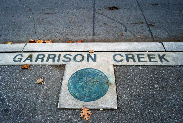
Urban Walk: Garrison Creek Ghost Hike: Earls Court Park to Fort York
https://hikes.brucetrail.org/event/urban-walk-garrison-creek-ghost-hike-earls-court-park-to-fort-york/Sorry, the registration cut-off time for this hike has been reached.Not a member? Click here to join today!Hosting Club: Toronto, Caledon Hills
Category: Urban Walk
Location (Google Maps): Meet in front of Joseph J. Piccininni Community Centre, 1369 Saint Clair Avenue West. Arrive by way of Line 1 on the St. Clair Streetcar or Line 2 from Lansdowne Station on bus 47A to Earlscourt Loop.Hike Leader(s): Andrew Proczek Click here to contact Hike Leader(s)
Pace: Moderate
Terrain: Flat
Distance: 12 kmDescription
Come and join me for a repeat of one of three ghost hikes offered in 2022. The ghosts are not former people but places and in this case a historical creek, long ago buried. Your fun assignment will be to find evidence of the Creek that was and to count the number of life size canoes placed along the route. This time around we will be walking in the reverse West To East, and North to South direction, ending at Fort York, which has free admission during March Break. You will have the opportunity to explore the exhibits at your leisure at the end of the hike.Public washrooms at the Joseph J Piccininni Community Centre to start (0 km), at Christie Pits Park (4 km), Trinity Bellwoods Park (7.5), Norway Park (10 km) and at The Fort York Visitor’s Centre (12 km).
Dropouts with TTC access anywhere along the route.
The route: https://onthegomap.com/s/e9k43bm0

Waterfront Trail 8/8 - Beechgrove to Pickering!
https://hikes.brucetrail.org/event/waterfront-trail-8-8-beechgrove-to-pickering-2/Sorry, the registration cut-off time for this hike has been reached.Not a member? Click here to join today!Hosting Club: Toronto
Category: Urban Walk
Location (Google Maps): Scarborough/Durham Waterfront TrailHike Leader(s): Brian Rideout Click here to contact Hike Leader(s)
Pace: Moderate
Terrain: Flat
Distance: 11.9 kmDescription
Please meet me at Kennedy Station by 10:04 am. We will take the 86 Scarborough bus departing 10:19 am. We will transfer to the 54 Lawrence Ave bus, arriving at Port Union Rd at 10:54 am. We start hiking 11:00 am.We will hike south to Lake Ontario and along the Waterfront Trail through Port Union and Rouge Hill to Pickering GO. The estimated distance is 9.8 km. Here is an online map of our route – Port Union to Pickering.
Bring a snack, at least 2 liters of water, and icers. Dress for cold weather.
Sunday Social hike - Snowshoe Bayview Escapment Side Trail loop
https://hikes.brucetrail.org/event/sunday-social-hike-snowshoe-bayview-escapment-side-trail-loop/Sorry, the registration cut-off time for this hike has been reached.Not a member? Click here to join today!Hosting Club: Sydenham
Category: Snowshoe Hike
Location (Google Maps): Meet in the north-east corner of the parking lot at Home Depot on Highway 26 on the east side of Owen Sound.Hike Leader(s): Bill Snel Click here to contact Hike Leader(s)
Pace: Leisurely: 3 km/h or less
Terrain: Moderate: Some hills and/or poor footing
Distance: 4.5 kmDescription
Carpool to the Bayview Escarpmwnt Side Trail and then snowshoe the Exploring Sydenham loop 12 / Looping Though Sydenham 2nd edition loop 6. This winds mostly through bush that should provide some protection from the weather. If unable to register or for information contact Bill Snel at w.snel2@gmail.com or landline (519) 470-0584. - Each hiker joining a Bruce Trail Club organized hike must perform a self-screening check before hiking.
- 11March 11, 2024
Beamsville Hike
https://hikes.brucetrail.org/event/beamsville-hike/Sorry, the registration cut-off time for this hike has been reached.Not a member? Click here to join today!Hosting Club: Niagara, Caledon Hills
Category: In and Out
Location (Google Maps): Meet in parking lot at Kinsmen Park, BeamsvilleHike Leader(s): Kathleen Manson Click here to contact Hike Leader(s)
Pace: Fast
Terrain: Moderate
Distance: 8kmDescription
We will head east and visit Cave Springs CA and return.It is mostly level with some hills and a lot of tricky footing.
Hiking poles are highly recommended. Wear supportive hiking boots with good tread. There are a lot of rocks and crevices.
Please arrive 15 minutes early.
If your plans change, please self-cancel as soon as possible so that other members may take your spot.
Hike Leader reserves the right to modify the hike.
- 12March 12, 2024
Urban Walk: Valley View Park Thornhill
https://hikes.brucetrail.org/event/urban-walk-valley-view-park-thornhill-15/Sorry, the registration cut-off time for this hike has been reached.Not a member? Click here to join today!Hosting Club: Toronto
Location (Google Maps): Parking lot at the corner of Bayview Ave, and Sycamore Dr. South of Highway 7
Hike Leader(s): Mohammad Aghamiri Click here to contact Hike Leader(s)
Pace: Moderate
Terrain: Hilly
Distance: 7-8 kmDescription
We will explore Valleyview and Huntington park and walk along German Mill Creek,It is winter time and trail is hilly bring proper clothing, ,hiking boots ,and ice cleats.
9:00 Rockway Long Hike
https://hikes.brucetrail.org/event/900-rockway-long-hike-2/Sorry, the registration cut-off time for this hike has been reached.Not a member? Click here to join today!Hosting Club: Niagara
Location (Google Maps): Meet at Rockway Parking lot on Pelham Rd
Hike Leader(s): Vic Gammon Click here to contact Hike Leader(s)
Pace: Fast
Terrain: Strenuous
Distance: +/- 10kmsDescription
To avoid the muddy conditions, we will be meeting at Rockway Parking lot (On Pelham Rd near Wessel) instead of Short Hills. We’ll hike out for 75 minutes then back to the parking lot. Bring water, poles, and icers if slippery. Please check the weather and dress appropriately.9:15 Short Hike - Short Hills Park, Pelham Rd
https://hikes.brucetrail.org/event/915-short-hike-short-hills-park-pelham-rd/Sorry, the registration cut-off time for this hike has been reached.Not a member? Click here to join today!Hosting Club: Niagara
Category: Loop
Location (Google Maps): Short Hills Provincial Park, Pelham Rd lotHike Leader(s): Helen Hermansen Click here to contact Hike Leader(s)
Pace: Medium
Terrain: Moderate
Distance: 6kDescription
Hike the main and side trails of Short Hills Provincial Park. Bring hiking boots and water. Icers may be required.Silver Creek- Great Esker Side Trail
https://hikes.brucetrail.org/event/silver-creek-great-esker-side-trail-3/Sorry, the registration cut-off time for this hike has been reached.Not a member? Click here to join today!Hosting Club: Dufferin Hi-Land
Category: Tuesday Hike
Location (Google Maps):Toronto Section, Map 13, Meet at intersection of 8th Line and 27th Sideroad, just north of Km 32.2 at 9.30 am
Hike Leader(s): Inge Eckerich, Les Babbage, Julie Daley, Tony Evangelista Click here to contact Hike Leader(s)
Pace: Leisurely
Terrain: Moderate, Slippery and Steep Sections
Distance: 6.0 kmDescription
We will hike a loop on the Main trail and Great Esker side trail. Short hike can return at any time. Icers and/or snowshoes may be required.Mineral Spring to Dundas Valley Trail Centre Loop
https://hikes.brucetrail.org/event/mineral-spring-to-dundas-valley-trail-centre-loop/Sorry, the registration cut-off time for this hike has been reached.Not a member? Click here to join today!Hosting Club: Caledon Hills
Category: Tuesday Hikers
Location (Google Maps): Parking lot on Martin Road behind the Ancaster Rotary Centre
(385 Jerseyville Rd W, Ancaster, ON L9G 3L5)Hike Leader(s): Jerry Bakker Click here to contact Hike Leader(s)
Pace: Medium – 3 to 4 km/hour
Terrain: Moderate – some hills and/or some poor footing
Distance: 11 kmDescription
We will hike down the hill into the beautiful forests of Mineral Springs. Then we will follow the Headwaters Trail eventually finding our way to the Hamilton-Brant Rail Trail. Following the rail trail, we will stop for lunch at the Dundas Valley Trail Centre. After our refueling, we will take various trails back up to the Ancaster Rotary Centre.It may be muddy but there are not rocks!
- 13March 13, 2024

8:30 Merritt Trail Hike Series #2
https://hikes.brucetrail.org/event/830-merritt-trail-hike-series-2-2/Sorry, the registration cut-off time for this hike has been reached.Not a member? Click here to join today!Hosting Club: Niagara
Category: Car Pool
Location (Google Maps): Meet at the Parking Lot at Book Depot , 67 Front St North Thorold, 43.128058, -79.202189
Carpool to parking lot on Merritt Island, WellandHike Leader(s): Sam Rutherford Click here to contact Hike Leader(s)
Pace: Brisk
Terrain: Easy
Distance: 15kDescription
Hike from Merritt Island , Welland to Thorold along the Welland Canal on mainly paved trails. Bring snacks and a drink .Earn the Merritt Trail badge for all 3 hikes
Lower Beaver Valley
https://hikes.brucetrail.org/event/lower-beaver-valley/Sorry, the registration cut-off time for this hike has been reached.Not a member? Click here to join today!Hosting Club: Blue Mountains
Category: Register on-line or sign-in morning of hike
Location (Google Maps): Hike meets in the parking lot behind Tim Hortons on First St. in Collingwood.Hike Leader(s): David Little Click here to contact Hike Leader(s)
Pace: Medium – 3 to 4 km/hr
Terrain: Moderate – Some hills and/or some poor footing
Distance: 11-12 kmDescription
We will begin the hike at the parking area on Johnston’s Sideroad at km
74.3 in the Beaver Valley section. We will hike south to km 68.3 and retrace our steps
heading north to the cars. Trail climbs a high meadow then east across to Cuckoo
Valley and down the Beaver Valley towards the high eastern edges of the escarpment.
Bring a snack or lunch and water.Winter Wednesday Walkers - Seigerman/Allan
https://hikes.brucetrail.org/event/winter-wednesday-walkers-seigerman-allan/Sorry, the registration cut-off time for this hike has been reached.Not a member? Click here to join today!Hosting Club: Beaver Valley
Location (Google Maps): Meet on the north side shoulder of Sideroad 22C, km 99.9, Map 28, Edition 31.
Hike Leader(s): Glenda Collings Click here to contact the hike leader.
Pace: Medium
Terrain: Moderate, Some steep sections
Length of Hike: Approx. 6 kmDescription
This is an out and back hike which takes us through the Siegerman property and the BTC acquired Allan property, a pretty creek, hardwood and evergreen forests and AVC trails snow covered in winter. On winter hikes we may encounter bare ground, light snow, deep snow, or ice. Please bring snowshoes and icers to our Winter Wednesday Walkers outings. Wear appropriate clothing for the weather plus water and a snack.COVID-19 Precautions Before, During and After your Hike
- Each hiker joining a Bruce Trail Club organized hike must perform a self-screening check before hiking.
Find Ontario’s self-assessment tool here: https://covid-19.ontario.ca/self-assessment/ - If you are experiencing COVID-19 symptoms, stay home.
Other Guidelines
- Arrive 15 minutes before the start of the hike.
- Wear sturdy footwear and appropriate attire for the weather and the terrain.
Hiking poles are a good idea in any season, especially if the terrain is rocky or slippery. In winter, snowshoes or icers/crampons are needed when conditions dictate.
Wearing appropriate clothing and footwear prevents injuries and shows consideration for a safe and positive group hiking experience. - Always carry I.D. and your health card.
- Bring sufficient water and snacks (or lunch if indicated). A minimum of 1L of water is recommended on all hikes, and 3L is recommended for long, challenging hikes in the heat of the summer.
- Bring sunscreen and insect repellent (for spring and summer hikes).
- Bring your own first aid kit.
- Please leave dogs at home.

Crawford Lake Loop
https://hikes.brucetrail.org/event/crawford-lake-loop-2/Sorry, the registration cut-off time for this hike has been reached.Not a member? Click here to join today!Hosting Club: Iroquoia
Category: Good Companions
Location (Google Maps): Crawford Lake Conservation Area, 3115 Conservation Rd., MiltonHike Leader(s): Anne Armstrong Click here to contact Hike Leader(s)
Pace: Leisurely – 3km/hr or less
Terrain: Moderate – Some hills and/or some poor footing
Distance: Approx. 7 km.Description
Come enjoy the beauty of the trails in this Conservation Area with its Meromictic Lake, a boardwalk around the lake, gorgeous views across Nassagaweya Canyon towards Rattlesnake Point and wood sculptures. Meet in the lower parking lot at 9:45 am. for a 10:00 am. start. A reservation with Halton Parks is necessary. Bring water, a snack, icers and poles if using. If you are unable to come on the day of the hike please text me at 905 617 3937.
Leader: Anne Armstrong
Family Hike at Riverside Woods
https://hikes.brucetrail.org/event/family-hike-at-riverside-woods/Sorry, the registration cut-off time for this hike has been reached.Not a member? Click here to join today!Hosting Club: Caledon Hills
Category: Kids
Location (Google Maps): Riverside Woods: Meet at the BTC Parking Lot, 713377 1st Line EHS, Mono.
From ON-9, head north onto 2nd Line EHS for 3 km. Turn left onto Side Road 5 for 1.5 km. Turn right onto 1st Line EHS for approximately 1 km. Continue straight into the parking lot.
From ON-10, head east on Hockley Road/Dufferin County Road 7 for 1 km. Continue straight onto Side Road 5 for 1.5 km. Turn left onto 1st Line EHS for approximately 1 km. Continue straight into the parking lot.Hike Leader(s): Lynn Dobson Click here to contact Hike Leader(s)
Pace: Leisurely – 3 km/hour or less
Terrain: Easy – mostly flat and usually good footing
Distance: About 2.5 kmDescription
Come and explore Riverside Woods on a family hike. Going at a leisurely pace, we will hike about 2.5 kilometres on Bruce Trail side trails. Family-friendly activities, like an opportunity along the way to stop and feed the chickadees, are included. Please come prepared for a March hike. It may be snowy, icy, or muddy! Bring water and snacks. No dogs please. - Each hiker joining a Bruce Trail Club organized hike must perform a self-screening check before hiking.
- 14March 14, 2024
Urban Walk: Valley View Park Thornhill
https://hikes.brucetrail.org/event/urban-walk-valley-view-park-thornhill-16/Sorry, the registration cut-off time for this hike has been reached.Not a member? Click here to join today!Hosting Club: Toronto
Location (Google Maps): Parking lot at the corner of Bayview Ave, and Sycamore Dr. South of Highway 7
Hike Leader(s): Mohammad Aghamiri Click here to contact Hike Leader(s)
Pace: Moderate
Terrain: Hilly
Distance: 7-8 kmDescription
We will explore Valleyview and Huntington park and walk along German Mill Creek,It is winter time and trail is hilly bring proper clothing, ,hiking boots ,and ice cleats.
9:00 am Long Hike Jordan to Moyer / Louth
https://hikes.brucetrail.org/event/900-am-long-hike-jordan-to-moyer-louth-61/Sorry, the registration cut-off time for this hike has been reached.Not a member? Click here to join today!Hosting Club: Niagara
Location (Google Maps):
Jordan Hollow Park 3039 King St Jordan
Pace: Medium
Terrain: Moderate
: 10kDescription
From Jordan Hollow Hike the main trail to Upper and Lower Balls Falls, Moyer Road or Louth and Return. You must register for each hike. Bring Poles, sunscreen, bug spray , snack and a drink and dress for the weather
9:15 Short Hike, Jordan Hollow
https://hikes.brucetrail.org/event/915-short-hike-jordan-hollow-100/Sorry, the registration cut-off time for this hike has been reached.Not a member? Click here to join today!Hosting Club: Niagara
Category: Loop
Location (Google Maps): Jordan Hollow Park, 3039 King St., Jordan StationPace: Medium
Terrain: Moderate
Distance: ~ 6kmsDescription
Hike the main and side trails around Jordan and Ball’s Falls. Bring hiking boots, water and icers. This hike qualifies for the Winter hiking badge. See website for details. https://niagarabrucetrail.club/badges/
Fletcher Creek Preserve, Puslinch, HCA Property
https://hikes.brucetrail.org/event/fletcher-creek-preserve-puslinch-hca-property-4/Sorry, the registration cut-off time for this hike has been reached.Not a member? Click here to join today!Hosting Club: Iroquoia
Category: General Hike
Location (Google Maps):Park at Fletcher Creek Ecological Preserve on Concession 7 just north of Gore Rd , Puslinch
HCA passes can be used or $8.00 per vehicleHike Leader(s): Cathie Green Click here to contact Hike Leader(s)
Pace: Medium – 3 to 4 km/hr
Terrain: Easy – Mostly flat and usually good footing
Distance: Approx. 10 kmsDescription
Easy, Moderate hike – Fletcher’s Creek Preserve is an abandoned quarry site that has been rehabilitated and is located at the headwaters of the Spencer Creek watershed
We will loop hike through the preserve as well as an adjacent trail that also was part of the quarry back in the day-lots of local history- it was the area swimming hole and some still use it.
Wear appropriate clothing and footwear for the weather-could be wet. Bring water, snack, hiking poles, cell
Please feel free to call or text me if you have any concerns or questions Cathie 416-931-2095 cathiekygreen@gmail.com
10;00 Merrit island loop
https://hikes.brucetrail.org/event/1000-merrit-island-loop/Sorry, the registration cut-off time for this hike has been reached.Not a member? Click here to join today!Hosting Club: Niagara
Category: Loop
Location (Google Maps): Merritt Island Park. Go North on Cross street to parking lot and play ground. Pass library on your right. Keep going.Hike Leader(s): Sylvia Wheeler Click here to contact Hike Leader(s)
Pace: Leisurely
Terrain: Easy
Distance: 10 kmDescription
Hike along the Welland Canal on paved and mud free trails - 15March 15, 2024

9:00 am Niagara-on-the-Lake Tour
https://hikes.brucetrail.org/event/900-am-niagara-on-the-lake-tour-20/Sorry, the registration cut-off time for this hike has been reached.Not a member? Click here to join today!Hosting Club: Niagara
Location (Google Maps): Veterans Memorial Park, park just outside the park on King Street
Hike Leader(s): Robin Garrett Click here to contact Hike Leader(s)
Pace: Medium
Terrain: Easy
Distance: 6-7 kmDescription
Each Friday we will explore different neighbourhoods, trails and parkland throughout Historic Niagara-on-the-Lake.Moderate pace with some weeks entirely on sidewalks and roads while others may include a mix of trails and paved pathways. Great way to build up endurance for longer more strenuous hikes.
Prepare for cooler windy conditions on open parkland and along Lake Ontario and Niagara River trails.
Plan to stay for conversation and a warm cup of coffee or tea at Sweets & Swirls, Community Centre, Niagara Stone Road, NOTL

Spring & Migration Monitor Hike
https://hikes.brucetrail.org/event/spring-migration-monitor-hike-3/Sorry, the registration cut-off time for this hike has been reached.Not a member? Click here to join today!Hosting Club: Peninsula
Location (Google Maps): Km 106 in the 31st Ed Ref Manual, at the Cape Chin North mail boxes before going down the escarpment
Hike Leader(s): Tamara Wilson Click here to contact Hike Leader(s)
Pace: Leisurely
Terrain: Difficult
Distance: 6kmDescription
Leaving the Cape Chin N mailbox parking area, we will progress south on the Main Trail to km 104.3 and head left on Cape Chin Meadows ST, crossing Cape Chin Rd N to the Otter Lake ST at . We will hike to the birding platform, spending a few minutes to take in any new migration arrivals and harbingers of spring. After a break at the birding platform we will continue on Otter Lake ST back to our parked cars. Depending on what we see, this hike could take up to 2 hours. Note: though a short distance, the ground will be rocky and uneven in places. Along the shores of Otter Lake, there could be some mud. - 16March 16, 2024
Car Hike: Hike of 2 lakes King city
https://hikes.brucetrail.org/event/car-hike-hike-of-2-lakes-king-city-12/Sorry, the registration cut-off time for this hike has been reached.Not a member? Click here to join today!Hosting Club: Toronto
Location (Google Maps): Park along Fairfield Dr. or Dufferin Street, Gather at trail head on Dufferin Street.
HIKE STARTS 8:AMHike Leader(s): Mohammad Aghamiri Click here to contact Hike Leader(s)
Pace: Moderate
Terrain: Variable
Distance: 14-17KMDescription
We will hike in trails around Seneca lake and Mary Lake,pass by Eaton and visit Pine farm where you can enjoy coffee,tea,apple pie during our snack time.Some safety procedures during the hike:
1-Hikers must stay between the leader and the sweep.
2-Hikers must advise the leader or the sweep if they wish to leave the group.
3- Hikers must follow the whistle instructions: 1 blast- stay where you are; 2 blasts come to the leader; 3 blasts – come to the leader quickly.
4-Hike leader may request volunteers to stop at trail intersections, they need to help hikers to the direction the group walk and wait till they see the sweep .
5-Hikers have to make sure they can see the persons behind and in front of them.
CANCELLED Winter Coach Trip: Highlands Nordic (Duntroon)
https://hikes.brucetrail.org/event/winter-coach-trip-highlands-nordic-duntroon-4/Sorry, the registration cut-off time for this hike has been reached.Not a member? Click here to join today!Hosting Club: Toronto
Category: Cancelled
Location (Google Maps): Highlands NordicHike Leader(s): Martina Furrer, Duro Vukman, Celia Ho Click here to contact Hike Leader(s)
Description
Cancelled because spring appears to be here to stay.Bus departs 10 York Mills Rd at 8:30 AM and Major Mackenzie Dr and HWY 400 Park and Ride at 8:50 AM. If you wish to be picked up at the Major Mackenzie Dr and HWY 400 Park and Ride, select that option when you register. Please arrive 15 minutes before departure. The bus waits for no one.
Join us for an awesome day of x-country skiing and snowshoeing/winter hiking. For trail conditions and information about the resort visit https://highlandsnordic.ca/.
Snowshoers: Join Duro and Celia for a guided snowshoe hike on the beautiful Bruce Trail. You must have your own snowshoes (or rent in the city) to participate in this hike. Pack lunch and water; you will be on the trail all day.
Skiers: Spend your day gliding through forests and fields on trails expertly groomed for classic and skate skiing. Enjoy beautiful views of the countryside and Georgian Bay. All skiing is self-guided.
Coach fares must be paid online when you register. Trail fees will be collected in cash on the bus. Masks are recommended while on the bus.
Hiking 101
https://hikes.brucetrail.org/event/hiking-101/Sorry, the registration cut-off time for this hike has been reached.Not a member? Click here to join today!Hosting Club: Toronto
Category: Car Hike
Location (Google Maps): Meeting Location
GPS N:43.307417, W:79.911580 – on the north end of Old Gueph Rd. Hamilton, Ontario. – From Hwy 403 take exit to Hwy 6 North, then take ramp towards Old York Rd. Turn left at Old Guelph Rd. to parking lot. Please arrive fifteen minutes early.Hike Leader(s): Ross Estrella Click here to contact Hike Leader(s)
Pace: Moderate
Terrain: Variable
Distance: 12 kmsDescription
Hiking 101Now that warm weather is fast approaching you may want to prepare to enjoy the outdoors. This special trip is for those interested in learning the basics of hiking and how to make the most of your hiking experience. This is (OTTLT) – on the trail learning and training. We’ll cover the essentials – the gears you need, hiking tips and trail etiquette. Learn the different type gears and what to expect during the hikes. We’ll cover the importance of Mountaineers/Hikers Creed! – Take nothing but pictures, Leave nothing but footprints, and Kill nothing but time. These principles will help preserve the natural beauty of our trails for generation to come. At the end of this trip, you’ll have the knowledge and confidence you need to get out there and hit our amazing trails! Whether you’re a beginner looking to explore or a seasoned hiker who just need a refresher, this Hiking 101 is perfect for you. You’ll have the oppurtunity to connect with other experts and make new friends. You’ll learn more about the Bruce Trail. During this trip we’ll do a 12 km in/out hike, on a moderate terrain at medium pace. Please bring snack/lunch, 2 liter of water. Sunscreen, sun head protection, bug spray and hiking poles if available. Wear appropriate clothing for the weather and hiking shoe.
Petun Conservation Area
https://hikes.brucetrail.org/event/petun-conservation-area-3/Sorry, the registration cut-off time for this hike has been reached.Not a member? Click here to join today!Hosting Club: Blue Mountains
Category: Register in person the morning of hike.
Location (Google Maps): Hike meets in the parking lot behind Tim Hortons on First St. in Collingwood.Hike Leader(s): Annette Sandberg Click here to contact Hike Leader(s)
Pace: Medium – 3 to 4 km/hr
Terrain: Moderate – Some hills and/or some poor footing
Distance: 7.3 kmDescription
We will park on the 2nd Line where we will start the hike to the Petun Conservation area. Here we meet up with the Petun Side Trail at the top of Osler
Bluff and will follow the blue blazed trail to form a loop back to the cars. Bring a snack or
lunch and water.9:00 Louth Conservation
https://hikes.brucetrail.org/event/900-louth-conservation/Sorry, the registration cut-off time for this hike has been reached.Not a member? Click here to join today!Hosting Club: Niagara
Category: In and Out
Location (Google Maps): Meet at Louth Conservation area parking lot on Staff Ave. Hike east to Effingham Rd and back.Hike Leader(s): Vince Zvonar Click here to contact Hike Leader(s)
Pace: Medium
Terrain: Strenuous
Distance: 12Description

9:30 Chloe Cooley Commemorative Hike
https://hikes.brucetrail.org/event/930-chloe-cooley-commemorative-hike-2/Sorry, the registration cut-off time for this hike has been reached.Not a member? Click here to join today!Hosting Club: Niagara
Category: In and Out
Location (Google Maps): Queenston Heights Park, Niagara River Parkway, Niagara-on-the-LakeHike Leader(s): Karen Couch Click here to contact Hike Leader(s)
Pace: Medium
Terrain: Easy
Distance: 7 kmsDescription
Chloe Cooley’s brave act of resistance on 14 MAR 1793, paved the way to freedom for so many Black enslaved men, women and children like her. This set the stage for the great freedom movement of enslaved African Americans known as the Underground Railroad. We will hike to where her bravery took place. This hike will take us along the General Brock Side Trail (GBST) and on then on the Niagara Parkway (NP). The GBST’s terrain is hilly/moderate, whereas the NP is flat/easy. We will then retrace our steps back.The terrain may be icy and/or snow covered. Hiking poles and icers are advised, depending on the conditions.
PLEASE NOTE: This hike counts as 1 of the 3 required hikes towards the Black History badge. If you will have hiked 3 hikes in this series, and are interested in receiving a badge, remember to bring your $10. This applies to anyone who has not already received this badge.
For more information about Chloe Cooley click on the link below.
https://www.ctvnews.ca/lifestyle/canada-post-honours-chloe-cooley-with-stamp-for-black-history-month-1.6256243
Car Hike: Scotsdale Farm
https://hikes.brucetrail.org/event/car-hike-scotsdale-farm-5/Sorry, the registration cut-off time for this hike has been reached.Not a member? Click here to join today!Hosting Club: Toronto
Category: Car Hike
Location (Google Maps): Scotsdale Farm, Map 13Hike Leader(s): Al Brown Click here to contact Hike Leader(s)
Pace: Moderate
Terrain: Variable
Distance: 13 kmDescription
We will complete a loop hike on the mail Bruce Trail and side trails including the Great Esker side trail. Trail conditions are expected to be late winter/early spring. After the hike those interested are invited to meet at the Shepard’s Crook in Georgetown for refreshments.Directions: From the 4o1 go north on Trafalgar Road pasts Georgetown. Trafalgar merges with Hwy 7 for about 3 km then separates to the right at the village of Silver Creek. From the stop light at Silver Creek go north on Trafalgar about 1 km to the entrance of Scotsdale Farm on your right. Drive in to the parking area about half a km.